At 8 o'clock in the morning, a car of four people left the Zhejiang Hotel where they were staying. Breakfast at the Zhejiang Hotel is served at 7:30, which is very early for Xinjiang. The driver is a man in his 30s. His surname is Xia. He is not tall. His ancestral home is not in Xinjiang. He has been in Urumqi for many years. He is a very real person. The other two are traveling ladies, also from Xi'an. After a few simple exchanges, it became clear that everyone was very easy-going, which indicated that this trip would be very enjoyable.
There were very few vehicles in Urumqi in the early morning. We quickly got on the Lianhuo Expressway and headed west. The Lianhuo Expressway is being expanded from two-way four lanes to eight lanes. There are many potholes on the road, and it is often necessary to change lanes from the opposite lane. Many bridges have not been repaired yet, so detours are required, and the road conditions have become very poor.
At about 11:20, we left the expressway at Dushanzi and turned to a southbound road. Not far ahead, we turned left and turned into a washboard road. Suddenly, the car was very bumpy. The driver Xiaoxia said, this The road is not long. After less than 2 kilometers, turn right and turn south again, and a flat sandy road leads into the distance. There are grasslands on both sides of the road. The grass is not very tall, like a green blanket. The mountain is far away from us. The ground is flat. There is a large ditch on the left, several hundred meters wide. I don't know how deep it is because I can't see the bottom.
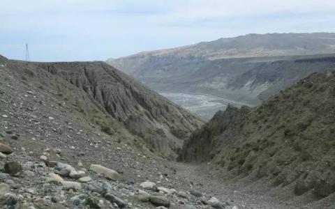
The sky was still very cloudy and the wind was very strong. You could feel blowing the car around. Half an hour later, the car stopped and they said they had arrived at the Grand Canyon. Although we had been told many times When we arrived at the Dushanzi Grand Canyon, we realized that this Grand Canyon was not the Anjihai Grand Canyon as we originally thought.
The car parked at the edge of the mesa. There are two mesas below. The first mesa is three to five meters lower than we are now, and one to two hundred meters wide. It stretches along the canyon, and the second mesa cannot be seen yet. The edges of the two mesas are unknown how big they are. The wind was very strong, and it was said that there was level 6 which I had never never passed. I felt that the two ladies might not get out of the car and go sightseeing, so I picked up my camera and went to explore alone. When I walked to the edge of the first mesa, I found that the second mesa was about ten meters lower and one or two hundred meters wide. The far side of this mesa was zigzag and very uneven. It should have been a flood. Formed by erosion and collapse. Running downhill quickly, and then ran to the edge of the mesa - there is a deep canyon below: From where I stand to the valley, it is one to two hundred meters high, and it is sixty or seventy degrees. It is about 700 to 800 meters from one bank to the other bank. The water flowing at the bottom of the valley alternates and merges, outlining a colorful pattern. There seems to be a hydropower station at the bottom of the ditch on the opposite bank, or it may be an irrigation and lifting station. The shore walls are all loose gravel, all gray-brown. You can vaguely see the snow-capped peaks on the south side. This canyon was carved out by heavy rains or floods caused by concentrated snowmelt in spring. The scene must be thrilling. At this moment, she was quietly prostrate under her feet.
The floods carved out a deep ravine on the platform, which stretched from the top of the platform to the bottom of the valley. It was very ferocious. I felt that I could not keep my friends who were traveling with me waiting too long, so I stood on the edge of the steep slope and took a few photos before starting to return. When I arrived at the higher platform, I found a lady who was traveling with me striding forward, so I went back with her. Next to the cliff, and then from the higher part of the ravine to the platform on the opposite side of the ravine, and then walked up the canyon for a while. The wind became stronger and stronger, the clouds became heavier and heavier, and when we were still two or three hundred meters away from the car, there were still faint raindrops. When our friends in the car saw us coming back, they said that the wind was so strong that it shook the car, which was scary. 

Back in Dushanzi, I found a restaurant on the side of the road. We couldn’t agree on what to eat, so we ordered each one. Some wanted to grab rice or stir-fry slivers. I ordered a rice soup in confusion, not knowing what it was. , when it was served, it was found to be gnocchi, and everyone thought it was a bit salty. Later, when eating again, they would deliberately ask for less salt.
Tonight’s residence is Bole. It’s an expressway from Dushanzi to Bole. The road condition is good. The cloud cover gradually decreases first, then increases, and then decreases again. An eagle Hovering on the grass, I fixed it with my lens. A friend who was traveling with him used a mobile phone app to check that it was rainy the next day in Sailimu and Yining. Xiaoxia said there was no need to check, and it was useless. The weather forecast in the plateau area was not accurate. He took another batch a few days ago. When the guests went to Sailimu, the forecast was also rainy, but the weather turned out to be particularly good.
Bole City is not next to the highway. After getting off the highway, we walked another twenty or thirty kilometers north, and the sun became brighter and brighter.
Bole City, located in the northwest of the Xinjiang Uygur Autonomous Region, is the capital of the Bortala Mongolian Autonomous Prefecture and the seat of the Fifth Division of the Xinjiang Production and Construction Corps. It is 524 kilometers away from Urumqi and borders Kazakhstan with a 95-kilometer border. , is an important border open city in western China. It has a national first-class open port - Alashankou Port (Alashakou City was established in 2012). Bole has a continental arid semi-desert and desert climate, with long sunshine hours and large temperature differences between day and night. The temperature in spring is variable, the summer is high and the climate is hot, accompanied by hot and dry winds, the autumn is crisp, and the winter is long and cold.
Bortala has a long history. During the Spring and Autumn Period and the Warring States Period, Bortala was a nomadic area for the Saka people. In the early Western Han Dynasty, Bortala was successively the nomadic land of Yuezhi, Xiongnu, Wusun, etc. In the second year of the Western Han Dynasty (72 BC), the Han Dynasty sent the school lieutenant Chang Hui to protect the Wusun soldiers, and Bortala was under his control. In 60 BC, the Xiongnu King Ruju surrendered to the Han Dynasty. The Western Han government set up the "Western Regions Protectorate" and Bortala was under its jurisdiction. During the Wei, Jin, Southern and Northern Dynasties, Bortala was the activity area of Rouran and Yueban. From the Western Wei Dynasty to the Sui Dynasty, it was occupied by the Western Turks. In the fourth year of Kaihuang in the Sui Dynasty (584), the Western Turks belonged to the Sui Dynasty government, and the Bortala area has since resumed its affiliation with the central government. In the Tang Dynasty, Bortala appeared in the history books as "Shuanghe". In 1124 AD, the Khitan Yelu Dashi established the Western Liao Dynasty in Central Asia. The Karluks then became part of the Western Liao Dynasty and established the Boluo City (called "Buci" in some historical books) in the southwest of today's Bole City. The Han people followed the Khitans and moved westward to Bortala. During the Yuan and Ming dynasties, Bortala was a nomadic area for the Mongolians. Genghis Khan once granted the Emin River Basin, including Bortala, to his third son Ogedei, and called it "Bolotuoer" for the first time. This was also the beginning of the formation of the place name "Bortala" today. In the 15th year of the Wanli reign of the Ming Dynasty (1587), the Oirat people entered Bortala as nomads. In the 16th year of Chongzhen (1643), the Junggar leader Batur Hun Taiji conquered two Kazakh tribes in the Alatoo Mountains, and Bortala was under the jurisdiction of the Mongolian Junggar tribe. The central government of the Qing Dynasty was established in 1644. At this time, the Oirat tribe gradually divided into four major tribes: the Dzungar, Khoshut, Durghut and Torghut, known in history as the Four Eleuth Tribes or the Four Oirat Tribes. After 1671, the Junggar nobles began to fight for power, and the civil war continued. It was not until 1758 that the Qing government, which had lasted for more than 70 years under the reigns of Kangxi, Yongzheng, and Qianlong, finally pacified the local separatist forces of the Junggar upper nobles, and then pacified the rebellion of the two Khojas in southern Xinjiang, reunified the Western Regions, and renamed them Xinjiang in 1884. From 1913 to 1942 (the second year of the Republic of China – the 31st year of the Republic of China), Jinghe County, Bole County and Wenquan County were successively established in Bortala and were under the jurisdiction of the Ili Administrative Office. On July 13, 1954, the Bortala Mongol Autonomous Prefecture was established, and ethnic regional autonomous institutions were successively established. In 1985, Bole County was abolished and Bole City was established. On December 28, 2012, the Alashankou Municipal Government was officially established and is under the jurisdiction of the Bortala Mongol Autonomous Prefecture.


At about 6 pm, we entered the urban area of Bole. The hotel we stayed in was in the north of Bole City. The car passed through the urban area from north to south along Beijing Road. Bole's construction is very good, especially what I didn't expect is that there are two waterscape wetland parks, one of which is located in the city center. Xiaoxia told us that there is a lot of food here and we can come here to eat in the evening. The Sunshine Hotel we stayed in was only two blocks away. After washing up for a while, we strolled to the Wetland Park. Xiaoxia had other arrangements and did not come with us.
There are not many people on the street, and the security atmosphere is much more relaxed than that in Urumqi. The wetland park is surrounded by new buildings, the waterfront, railings, blue sky, and reflections, making it appear peaceful and harmonious. We walked around the food street of a modern and fashionable shopping mall. Before it was time to eat locally, there were only three of us on the block. I found a restaurant that served chicken on a large plate, ordered three or two dishes, and ordered two bottles of Wusu beer, the red label one. Jinghe's large plate chicken is the most authentic, but the taste of this restaurant is not very good. Maybe because I was hungry, I ate all the dishes.
After dinner, we took a walk along the waterfront to appreciate the scenery of this emerging city.
The breeze is gentle, the flowers are blooming, the sun sets, and the shadows fall into the sky. 


