
When you come to Xinjiang, you must drive on the Duku Highway. This road can be said to be the ultimate dream of self-driving enthusiasts.
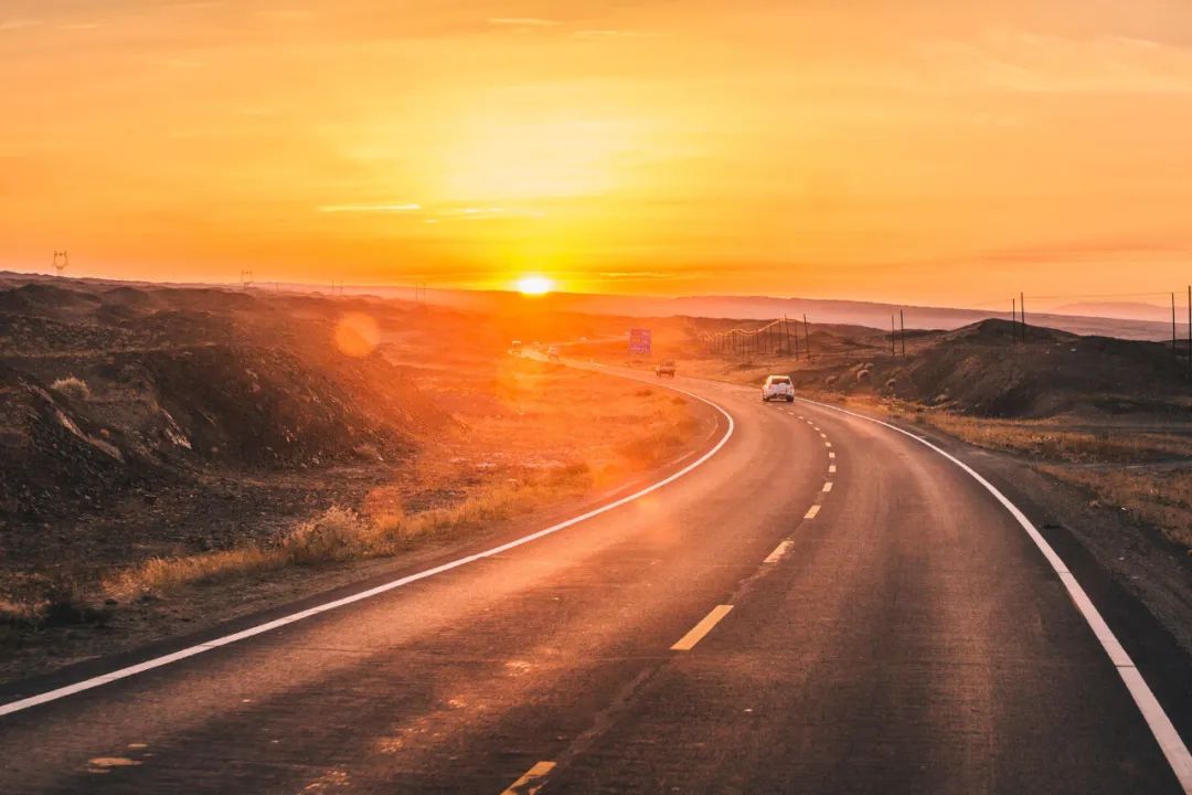
Duku Highway is the section of National Highway 217 from Dushanzi to Kuqa in Xinjiang and is an important trunk line connecting northern and southern Xinjiang. It has shortened the original distance between northern and southern Xinjiang by nearly half, which can be called a monument in the history of China's highway construction.

An absolutely unforgettable road, it traverses the Tianshan Mountains, winding, steep and stunning all the way; this road embodies too much human spirit and tens of thousands of people went through hardships and hardships for ten years to build it. This is a heroic road. Road, which brings together all the shocking beauty of Xinjiang, is also known as "the most dangerous road in China".

Traffic control, road closures, and snow removal are carried out every winter. The road is closed from October to May of the following year when the weather becomes warmer. Once opened, it becomes a world-class scenic corridor, attracting many people to come here to see its elegance.

From red soil and rocky mountains without any vegetation to green grass as far as the eye can see, from fragrant wild flowers to chilly white snow. Let you feel the magic of "different days in ten miles and four seasons in one day" and the excitement of "Snow in Tianshan Mountains in July".

The total length of Duku Highway is 561KM. Due to different landforms and highway conditions, it is divided into 3 sections from north to south:

Northern section of Duku Highway:
Dushanzi-Jorma-Nalati (250KM)
Starting from Dushanzi, the winding mountain road needs to pass through [Hashilegenda Ban] (3390 meters) and [Yuximole Gaidaban] (3400 meters). There are many sharp turns, tunnels, and culverts along the way. Temporary closure due to severe weather such as rainfall, snowfall, avalanche, etc.

The northern section is the most difficult section of the Duku Highway, so it is the last section open to traffic every year. It is also the section with the richest scenery on the Duku Highway.

Middle section of Duku Highway:
Nalati-Bayinbuluke (60KM)
Starting from Nalati, passing through the Gongnaisi River Valley and heading south, there is a rest area where you can stop and take photos. Finally, we arrived at Bayinbuluk Town and enjoyed the famous "Nine-Bend and Eighteen-Bend Sunset", which is also a must-take route for many tourists coming to Xinjiang.

The middle section of Duku is currently allowing buses and trucks to pass, but it will sometimes be closed and detoured due to rain or snowfall.

Southern section of Duku Highway:
Bayinbuluke-Kuqa (250KM)
Starting from Bayinbuluke Town, go all the way south through Bayinbuluke Wetland, and climb up to [Tielimai Tida Ban] (3200 meters), where the landscape will change dramatically. The plateau wetlands that were originally lush with water and grass gradually disappeared and gradually turned into Gobi rocky landforms.

Duku Highway Route Recommendations:
1. Yili Duku Small Ring Line
D1: Urumqi-Sailim Lake (543km)
After breakfast, go to Sailimu Lake, the "last tear of the Atlantic Ocean", have lunch on the way, and arrive at Sailimu Lake in the afternoon. Arrange a tour around Sailimu Lake, along the scenic road around the lake, appreciate the beautiful landscape of the mountain lakes from different angles, and encounter the White Swan Nature Reserve. Tonight, we stayed in a hotel near Sai Lake, surrounded by forests, grasslands, and mountains. You can also come out to watch the stars at night.

D2: Sailimu Lake-Guozigou-Horgos Port-Lavender Base-Yining (144km)
Depart at the right time in the morning and go to Guozigou, known as "the first scene in Ili", to enjoy the beautiful scenery of Guozigou. Then go to Horgos Port and check in at the national gate. Finally, we arrived at the lavender base and enjoyed the beautiful lavender fields under the sunset.


D3: Yining City-Zhaosu (188km)
Today we take the Yizhao Highway, "one of the three most beautiful highways in Xinjiang" [Yizhao Highway]. The mountain road is winding, and the blue sky and white clouds are within reach. Every turn on this road will be amazing. When you climb over Wusun Mountain, you will see beautiful Zhaozhou along the way. Su grassland, groups of cattle and sheep, walking and playing along the way, arrived at [Zhaosu] in the afternoon.


D4: Zhaosu-Tex (62km)
Zhaosu from June to July is also the season when rapeseed flowers and fragrant perilla are in full bloom. Passing by the Tekes River Wetland, if you are lucky, you may encounter groups of Zhaosu Tianma galloping on the prairie.

Visit the [Xiata Ancient Road], which connects the north and south of the Tianshan Mountains. It is the most famous and steepest ancient pass on the ancient Silk Road. It is also known as the "Xuan Zang Road" in the outdoor world. You can take a stroll along the grassland trails, which are dotted with wild flowers, cattle, sheep, streams, and often silly marmots.

Leave at the right time in the afternoon and head to the beautiful small town in the hinterland of the Tianshan Mountains [Tex]. Tekes, also known as Bagua City, is famous for its city building in the form of Bagua from the Book of Changes. After arranging your accommodation, you will have free time to explore the Turks Bagua City and taste the special delicacies at the Turks Night Market.

D5: Turks-Nalati (269km)
After June every year, large groups of livestock move in, entering the golden season of the grassland. Various gatherings of grassland people are often held here. You can also experience Kazakh folk customs locally.

You can also go to the Internet celebrity check-in site - Tawusani. Tawusani is Kazakh and means "beautiful ravine". In this scenic spot, you can see the perfect combination of snow-capped mountains, forests, hills and meadows. Because the natural landscape is vertical and three-dimensional, this is also a popular check-in spot for many tourists and friends who must stop for travel photography.

The Nalati Grassland Scenic Area was developed earlier and has mature facilities, making it comfortable and convenient to visit. It is recommended to visit for about 4 hours and stay in a hotel near Nalati.

D6: Nalati-Bayinbuluke (63km)
There are pastoral songs singing along the way, and the continuous snow-capped mountains in the distance are endless scenery. Soon Bayinbuluke appeared in front of him.

After arriving at Bayinbuluke Town, take a shuttle bus to enter the scenic spot. Along the way, you can enjoy shooting the plateau wetlands, the beautiful Swan Lake, Bayinbuluke Wetland Grassland and the sunset over the Kaidu River’s nine twists and turns. In the evening when the weather is fine, you will see a string of sunsets reflected on the river; return to the hotel after sunset rest.

D7: Bayinbuluke-Duku Highway-Kuitun (381Km)
Today we will drive through the [Duku Highway]. Today we will go through the Tianshan Mountains along the northern section of the Duku Highway, and experience the charm and scenery of the Duku Highway, one of the top ten roads that must be taken in this life. Enjoy the four seasons in one day. Along the way there are vast grasslands with beautiful scenery, towering cloud mountains and snow-covered ridges, and endless beautiful scenery along the way.

D8: Kuitun-Dushanzi Grand Canyon-Urumqi (244km)
Today we visit the spectacular Dushanzi Grand Canyon, with its criss-crossing ravines, chopping cliffs, meandering water, majestic deep valleys, and colorful rocks. After having fun, return to Urumqi.

Kind tips:
1. Yizhao Highway can be opened to traffic in early June in previous years. The time will vary every year. If it is not accessible due to force majeure (such as weather, traffic police road closures, etc.), a detour will be required.
2. Yizhao Highway is a two-way single lane with very steep cliffs. There are relatively few fixed parking areas along the way. The driver will arrange parking based on actual road conditions, with safety first.
2. Panoramic tour of Duku
D1: Urumqi-Duku Highway-Nalati (511km)
Today, we drove through the Tianshan Mountains in Xinjiang. The Duku Highway connecting northern and southern Xinjiang is more than 500 kilometers long. It is a miraculous and dangerous road through mountains and ridges. One-third of the road along the way is surrounded by cliffs, and one-fifth of the road is surrounded by cliffs. Underground is high mountain permafrost. Experience the charm and scenery of Duku Highway, one of the top ten roads you must take in your life. There are several viewpoints along the way where you can stop and take photos.

D2: Nalati-Bayinbuluk
After breakfast, visit [Nalati Grassland] In the vast grassland, ride a horse and swim in the green ocean. Take out your camera and take selfies to take pictures of the beautiful scenery as a souvenir; there will be some optional activities on the grassland: horse riding , powered delta wing, taking photos with the eagle and other projects. You can choose according to your personal preferences.

After that, we will continue on the [Duku Highway] (middle section) to the most beautiful wetland in China [Bayinbuluke].

Along the way, you can enjoy the virgin forest of the Gongnaisi River Valley, where you will find the most beautiful snow-capped spruce trees in China. Along the way, there are blooming mountain flowers, dancing bees and butterflies, flocks of cattle and sheep, and dotted yurts, and you can enjoy the beautiful scenery beyond the Great Wall.

D3: Bayinbuluke-Kuqa (258km)
Depart after breakfast and continue crossing the [Duku Highway] (southern section). The Bayinbulak grassland in the early morning is beautiful and moving. The sun is shining on the green grassland, the smoke is curling up from the yurts, groups of cattle and sheep are grazing leisurely, and horses are galloping, everywhere you look.

Passing the [Big and Small Dragon Ponds], the green spruce green grass on the hillside is layered under the reflection of the snow peaks, which makes people relaxed and happy, and makes you forget to leave. It is a good place for summer vacation. Then we arrived at the [Tianshan Mysterious Grand Canyon]. The Grand Canyon was formed by reddish-brown rocks carved by wind and rain for hundreds of millions of years. It has winding paths and unique caves. It is known as the "Antelope Valley of Xinjiang".


Then go to visit the largest grotto group in Xinjiang [Kizil Thousand Buddha Caves]. Its history is more than a century earlier than the Mogao Grottoes in Dunhuang. It is the earliest grotto excavated in China and an important part of the Silk Road World Heritage. After thousands of years, there were many monks, and it was from here that Buddhism was introduced to the Central Plains.

After the visit, go to the small southern Xinjiang town [Kuqa] to check in. Kuqa, known as Qiuci in ancient times, is an important node of the "Ancient Silk Road" and has a rich exotic customs. In the evening, you are free to explore southern Xinjiang delicacies (barbecue, noodles, peppercorn chicken, meatball soup, etc.).

D4: Kuqa-Hejing (368km)
After breakfast at the hotel, drive to [Bosten Lake], which is the largest freshwater lake in our country. The most eye-catching thing is the area of Bosten Lake. It is about 800 square kilometers of water and looks endless.

Visit Bo Lake. In the summer, the lake surface is rippling, the wetlands are warm, and there are lotus flowers and migratory birds that can be photographed. The scenery is the most beautiful. In addition to these natural scenery, Bosten Lake also has barbecues and hotels everywhere in the scenic area, as well as endless seafood. .

D5: Hejing-Urumqi (434km)
Today we return to Urumqi, drive all the way to see the northwest scenery, and end our trip.

Latest news on Duku Highway:
1. The Kuqa section managed by the Aksu Highway Administration Bureau was the first to be reopened to traffic;
2. The section from Qiaoerma to Bayinbuluke will not be fully cleared until May 31 (managed by the Nalati Branch of the Yili Highway Administration Bureau);
3. The section of the Dushanzi-Hahilgen Tunnel is located on the northern slope of the Tianshan Mountains. It is the section with the most serious geological disasters on the entire line, and is also the key to whether the entire line can be opened to traffic. Due to serious landslides and snow-proof tunnels, this section is currently open to traffic. Not sure yet.
What you must know when taking the Duku Highway
1. Passing vehicles: Non-operating vehicles with seven seats or less and not including seven seats can pass. 7-seater off-road vehicles can pass.
2. Avoid the peak period: The peak period is from July to August, and weekends are also very congested during this period!
3. Nighttime restrictions: Entry into the mountainous area is prohibited from 20:00 to 8:00 am, please arrange the time accordingly.
4. Refueling and supplies: There are no service stations on the winding mountain road. Please fill up at the township gas stations before entering the mountains.
5. Travel supplies: There are no stores, hospitals, car repair shops, etc. on the winding mountain road. Prepare hot water, snacks, etc. in advance according to personal conditions.
6. Road condition information: The entire Duku Highway is an asphalt road. It is a high-altitude winding mountain road. Landslides and rockfalls are normal. Traffic control will be implemented in bad weather (such as rain, snow, fog, landslides , falling rocks, etc.). The entire mobile speed measurement is 40-60KM/H. When encountering a speed measurement camera, please do not exceed 40KM/H to pass.
7, Safety: Pay attention to side slipping on the gravel road on the mountain. It is easy to slide when passing through rockfall areas. Therefore, you should pay attention when driving, pass quickly, and do not stop. When you encounter danger while traveling on the Duku Highway, you can directly use your mobile phone to dial the emergency number. The call will be to Wusu. Add the area code 0992 and the call will be to Kuitun. Before setting off, be sure to remember the emergency call number of Duzishan, pay attention to Xinjiang Radio, and pay attention to any accidents on the Duku Highway.