Day6 Shuangse Lake-Mangya City, 293 kilometers, 4 hours
We left Shuangse Lake at around 3pm and headed to Mangya. The rest of the journey is relatively boring, but you can still see the Yadan landform from time to time.
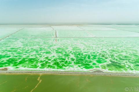
We passed by Mangya Emerald Lake at 6:30 pm and saw that the sunset was just right. We temporarily changed our plan to go there the next day and went to see the Emerald Lake at dusk first.
The total area of Mangya Emerald Lake is about 26 square kilometers, which is larger than the Emerald Lake of Daqaidan. It is located on the eastern edge of Gaskule Lake, southwest of Huatugou Town, Mangya City, Haixi Prefecture. It is adjacent to the towering Kunlun Mountains in the south and the Altyn Mountains in the north. It is 32 kilometers away from Huatugou Town, where the Mangya government is located, and less than 30 kilometers away from the airport. Mangya Emerald Lake is a rich and beautiful artificial salt lake. It is a magnesium sulfate subtype salt lake. It is rich in lithium, potash fertilizer, mirabilite and other salt compounds. It is the third largest artificial lake in Haixi Prefecture. The scenic spot currently only charges a ten yuan garbage management fee, and you can drive around.
Here, the strip-shaped salt crystal pavement divides the lake into connected lakes of different shapes and sizes. The lake water has different colors. People can step on the crystallized areas in the lake water and walk to the middle of the lake to take pictures of the sky mirror.

On the lake side, there is still Yadan landform. The blue and green lake water and white crystals are against the yellow background. The whole picture is very eye-catching.

Under the afterglow of the setting sun, the light is soft and the lake surface is glowing with golden light. Watching the sun slowly setting on the lake surface, the entire lake area is particularly peaceful and beautiful.


Emerald Lake Sunset
It's very close to Mangya City from Emerald Lake, but Mangya City is undergoing massive infrastructure construction. The roads are dug in a mess, and the navigation is completely confusing. Looking for a place to eat is hit by obstacles. Later, I ordered two side dishes at a Hunan restaurant and enjoyed a hearty meal. The boss is from Shandong and is very lively and friendly. He is very good at chatting with guests and is very happy and relaxed. I like this state of my boss very much. No matter what I do, this kind of happiness from the heart is very important.
The Mongolian pronunciation of Mangya is "Mangnai", so the local people pronounce the word "Ya" as (ai). Mangya is located in the northwest of the Qaidam Basin, at the transportation chokepoint of Qinghai and Xinjiang, and is a must-pass for the ancient Silk Road. It borders Xinjiang Ruoqiang to the west, Daqaidan to the east, Aksai, Gansu to the northeast, and Golmud to the southeast. The city is even more lonely than Sansha City in Hainan. There is no organized city within a radius of 350 kilometers, and there is no county within 200 kilometers. The nearest city is Dunhuang, and the straight-line distance is about 390 kilometers. Mangya is an oil city, and oil workers can be seen everywhere in the city. Thumbs up for these workers who are working hard to develop oil in the Gobi Desert far from home!
Day7 Mangya-Aiken Spring (42 kilometers)-Emerald Lake (120 kilometers)
Depart at 8 a.m. to go to Aiken Spring, known as the "Eye of the Devil". The road is a rural yellow mud road, very bumpy, with many extremely uneven shell craters. Generally speaking, it will be more difficult for a car to enter. In many sections, RVs seem to be in danger of overturning. Along the way, we saw a large lake with water birds playing in it. From what I have seen, I feel that Qinghai is rich in water resources, with large lakes everywhere.
Aiken Spring is located in Moheerbrook Village, Huatugou Town, Mangya City, Haixi Prefecture, Qinghai Province. It is located on the vast land at the foot of the snow-capped mountains. It has a wide view and is known as the "Eye of the Earth" and "The Eye of the Devil". It takes about an hour to reach the gate of the scenic spot, and the fee is 10 yuan.

Before I came here, I heard from traveling friends that Aiken Spring is a scenic spot that you will definitely regret visiting. Because when viewed from a flat surface, Aiken Spring is just a pool of gurgling spring water in the middle of the calcified sulfur ground, and there is nothing special about it at all.


Although the scenic area is very considerate, it is also ugly to build a high platform next to it so that everyone can take a look at Aiken Spring from a high angle, but it is of no use and still does not look special.

In the distance is a high platform built

The viewing angle from the high platform is also very limited
However, when the drone flew to a high altitude and looked down, Aiken Spring showed a very different picture, especially the colorful colors, which were completely beyond what could be imagined by looking at it.

The entire area is brightly colored, with white salt crystals on the outermost edge, yellow calcified sulfur on the inner edge, and a boiling spring in the middle. The bottom of the spring is reddish-brown, and it does have the feeling of "devil's eye". Aiken Spring has a diameter of more than 10 meters. The spring is like boiling water, rolling up and up continuously. The sulfur minerals around the spring have been precipitated for a long time, forming various and beautiful pictures with colorful colors. Viewed from the air, the spring, the gushing spring water and the reddish-brown ring-shaped sediments on the surrounding land form a peculiar pupil shape, like an eye embedded in the earth. The uncanny craftsmanship of nature is breathtaking!

500 meters height

300 meters

100 meters
So to see whether Aiken Spring is worth traveling for more than an hour, I think it’s not worth it for ordinary tourists because they can’t see anything at all. Unless... you just want to play with drones. Because what makes Aiken Spring so attractive is that the high-altitude view is particularly stunning! This is a special place where drones look better than flat photos, and flat photos look better than real scenes.
Aerial photography (headphones + horizontal screen is preferred )
Depart Aiken Springs at 11 o'clock and head to Emerald Lake again. The Emerald Lake at noon is much tougher than in the evening. The water is not so green, but it is still pure and beautiful.


Thanks to more than ten years of careful "beautification" by potash workers, the color of magnesium sulfate brine is pure and clear. The Emerald Lake under the sun is like a lens with a filter, embedded under the Aqiqi Mantag Mountain, glowing with emerald green gemstones. One side of the lake reflects the Yadan Devil City, and the other side reflects the Kunlun Snow Mountain. , the whole scenery looks beautiful.


There is a place marked as the best photography spot in the scenic spot. You can walk along the salt road to the middle of the lake to truly capture the feeling of a mirror in the sky.


There is also a transparent glass boat that allows you to go to the middle of the water on a limited basis and experience the feeling of being in the lake.

After walking around, Mangya Emerald Lake is the farthest and hardest among the several salt lake landscapes, but it is also the most beautiful and worthwhile!
Complete collection of aerial photography (preferably with headphones + horizontal screen)
We left Mangya Emerald Lake at 3pm and headed to Lenghu Town.
Day7 Mangya Emerald Lake-Lenghu Oil Base, 285 kilometers, 4 hours
An hour and a half after setting off, we entered the desert area. There are Yadan landforms from time to time, which are quite spectacular, but driving is also quite boring. Arrive at the Cold Lake Oil Base site at 6:30.

This is an abandoned oil base, the same as the old mining site in Sandaoling, Hami, Xinjiang. It is now full of ruins, covering a large area, standing in the desert, witnessing the end of a once prosperous place.


I am too lazy to take aerial photography, the landscape here is also good for environmental portraits.
Not wanting to go any further, I decided to live in the new cold lake town near the ruins of the oil base. I thought this was a remote town, but I didn’t expect that there were so many tourists and accommodation was tight. It seems that tourism in Qinghai is quite popular this season. I found a family room with hot water and was very satisfied!
Day8 Lenghu Town-Aksei-Dunhuang, 260 kilometers, 4 hours
I originally planned to stop by Oboliang Yadan before going to Lenghu, but I couldn’t find the route on the navigation system on the way to Lenghu yesterday. I asked around in Lenghu Town this morning and no one could tell me how to get there. , besides, if you go there, you have to go back a lot, and the time is limited, so we have to talk about it later (I later learned that going to the Mars base is actually Oboliang, but I was frightened by the name at the time, and I didn’t want to live in a space warehouse, so I didn’t even think about it. plan to go).
Departing at 11 o'clock, we quickly arrived at the boundary of Jiuquan. I saw the Dasugan Lake Migratory Bird Sanctuary on the roadside and drove to the lake to have a look. Migratory birds are invisible, and the color of the water returns to the common hues of plain lakes. After seeing so many beautiful and pure plateau lakes, this lake suddenly lost its appeal. Back on the road soon.
Arrive at Dunhuang at 3 o'clock. In the evening, we went to the Tianhewan Customs Garden Mongolian yurt to eat barbecue. The boiled mutton was especially delicious. A friend said: There are old friends when I leave Yangguan in the west, and I have wine when I come to Dunhuang.