2019.8.12
Monday

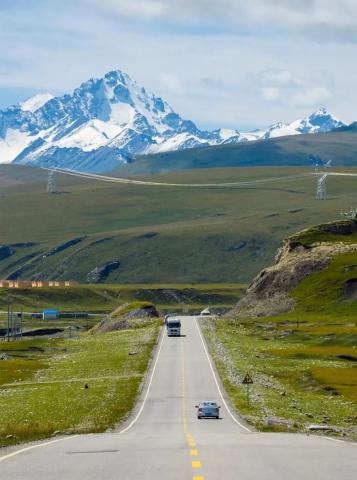
▲Duku Highway/Photographer Adu
From northern Xinjiang to southern Xinjiang
Crossing Duku Highway
Encounter beautiful scenery from heaven to hell
No.
20
stand
– Duku Highway –
Nalati Town – Bayinbulak Grassland – Tielimai Tidaban –
Big and Small Dragon Ponds – Tianshan Mysterious Grand Canyon – Kuqa County 335KM
Duku Highway is also commonly known as Tianshan Highway
It is a section of the G217 line
Starting from Dushanzi in the north to Kuqa County in the south
It has a total length of 531 kilometers, running through the north and south of the Tianshan Mountains.
You can travel through four seasons in one day
Appreciate the different scenery of northern and southern Xinjiang
Among them, more than 280 kilometers of road sections
They are all above 2,000 meters above sea level.
One-third of the Duku Highway is covered with cliffs
One-fifth of the land lies in alpine permafrost
Crossing nearly ten major rivers in the Tianshan Mountains
Climb the four icebergs that are covered with snow all year round
The world's only snow-proof corridor
The country's highest altitude Hahilgan Tunnel
Only open for 5 months each year (June to October)

▲Duku Highway Line
Duku Highway is divided into two sections: north and south.
From the direction of Dushanzi District, Karamay
To Bayinbuluke Grassland
Commonly called the northern section
Tielimaiti Tunnel at an altitude of more than 3,200 meters
It is the watershed between southern Xinjiang and northern Xinjiang
It can be clearly seen from the picture below
After crossing the Tilimati Tunnel
The oasis becomes a desert


▲Picture from Planetary Research Institute
Famous attractions in the northern section include
Dushanzi Grand Canyon (Kuitun Grand Canyon)
It is called "Kuitun Grand Canyon" because
The Kuitun River passes through the valley to form an alluvial canyon.
It’s called “Dushanzi Grand Canyon”
Because it is located in Dushanzi District
Dushanzi Grand Canyon turns out to be free
It was developed into a tourist attraction during the summer vacation of 2019
It is said that there are guardrails everywhere in the scenic area
I can’t even get good shooting angles.
We also built a lot of amusement facilities
Seriously affects the line of sight and the experience is extremely poor
There is a place worth visiting in the northern section
It’s Tangbula Baili Gallery
Visited Nalati, Bayinbuluk and Tangbula
Friends from these three grasslands say
The scenery in Tangbula is the most beautiful
The original plan was to go to Tangbula to buy the specialty black honey.
It's a pity that due to the previous road conditions,
I can only give up this trip

Tangbula Baili Gallery

Dushanzi Grand Canyon
I didn’t complete the entire Duku Highway this time.
I left a small regret
Due to the frequent occurrence in the northern section
Natural disasters such as landslides and mudslides
So friends starting from Dushanzi
Be sure to always pay attention to traffic reports

▲On August 8, 2019, the northern section of Duku Highway from Dushanzi to
A large mudslide disaster occurred at K636 of Qiaoerma Road Section
We set off from Nalati Town
The navigation shows a total of 322 kilometers to Kuqa.
It takes just over 4 hours to arrive
In fact, there are stops and starts all the way
It took 13 hours to take photos and sightseeing
Friends who like photography should try to leave as early as possible
Approaching the intersection of G218 and G217
There is a viewing platform in Nalati National Forest Park
You can park and rest
The park is located at the northern foot of Nalati Mountain, a branch of the Tianshan Mountains.
upper reaches of gonnas river
The creek is gurgling and the clouds are towering
The air is exceptionally fresh and the temperature is low


▲Taken at G218 Nalati National Forest Park Observation Deck
Less than 1 hour from Nalati Town
Just on the G217 Duku Highway
The road conditions are much better than expected
Nalati Town, Bayinbuluke Town
There are gas stations
The rest of the way to
There are gas stations only in Kuqa area.
The whole road to Kuqa
Almost every 7 to 12 kilometers
There is a small parking area
You can use the restroom or buy something
Don’t worry about not being able to do it along the way
Problem with parking and taking photos
There are people setting up tents and selling things along the way.
At first I thought the long white string was garlic
When I got closer, I realized it was a wild mushroom.
Half an hour after driving onto the G217 Duku Highway
Arrive at the first shooting point

Enter G217 Duku Highway

first shooting point

There are parking areas along the entire road

The scenery in the parking area is also good
, you can take pictures of the road on the turning hillside
Climb up the hill and look ahead
It feels like you can see the small mountains
The Nalati section is all
Alpine meadow and aerial forest landscape
Alternate distribution of forests and grasslands
Forming a "Pied Forest"
The temperature here is lower
All the vegetation is not too withered and yellow
Just wear an early autumn coat

On the turning hillside

Alpine meadows and aerial forests

Beautiful scenery shrouded in mist

List of small hills

piebald forest
The view from the back of the mountain is also very broad.
Photos can’t convey this feeling
You must come up and take a look when you drive here.
The gloomy weather brought
Beautiful scenery shrouded in mist
It's very windy and cold on the top of the mountain
Be sure to wear a jacket


▲Taken on Duku Highway
The altitude is slowly climbing
Along the way, meadows, spruce trees and sea of clouds
took us several hours
Stop and go shooting


▲Taken on Duku Highway
After turning a corner
The green world comes to an abrupt end
Devastated mountains and thick fog
quickly surrounded us
Here is paragraph 799 of G217
Building corridors with glass windows on the road
It seems like there are quite a lot of foggy days here.
except summer season
There should be heavy snowfall on this stretch of road.
The further we go, the more foggy it gets.
Visibility is about 20 meters
But for experienced drivers in the west,
This road condition is not difficult

Paragraph 799 of G217

Beautiful scenery shrouded in mist

Visibility is about 20 meters
The foggy area passed quickly
After climbing over the top of the mountain, another piece of new green appeared
This belongs to the Nalati Grassland
The junction with Bayinbulak Grassland


A large group of sheep are crossing the road
Look carefully, their heads are all black.
This is the famous black-headed sheep of Bayinbuluke

The terrain gradually becomes flat
Slightly yellow grassland appears
There are many black-headed sheep on both sides of the road
After entering the Bayinbuluke section
The roads are smooth and smooth
No risk factor


In front of the road, clouds wrap around the snow-capped mountains like Hada
This is Tianshan Mountain, and over this mountain is Southern Xinjiang

Bayinbuluke Grassland
Mongolian means "rich spring"
Located in the middle of the Tianshan Mountains
In the Alpine Yurdos Basin
Surrounded by snowy mountains
Approximately 2,500 meters above sea level
Area: 23,835 square kilometers
It is the second largest grassland in China
Second only to the Erdos Grassland in Inner Mongolia
The grassland is flat and rich in water and grass.
It is a typical grass meadow grassland
It is also one of the most important animal husbandry bases in Xinjiang

▲Bayinbuluke in Yourdus Basin/Photographer Wang Hanbing
I heard that there are a lot of mosquitoes in the Bayinbulak grassland.
As a result, the day we came
I don’t know if it’s because it’s too windy or it’s cold.
Anyway, not a single mosquito appeared
The August season makes the scenery here
Got a lot of discounts


▲Photographed in Bayinbuluke Grassland
Duku Highway is the entire Xinjiang
The road with the largest traffic volume
RVs and pickup trucks are all welcome.
But even in the peak tourist season
There was no traffic jam either
More and more people come to Duku Highway for self-driving
As a result, the environment here is getting worse and worse.
Along the way, I saw many people casually
Throw trash out of car window
Or there are large trash cans in the parking area
Throw the trash on the ground too
This garbage is blown by the strong wind
Will be blown to all parts of the grassland
Very unsightly
I hope that everyone will gradually enrich their material life.
At the same time, we should also pay attention to spiritual civilization
Keep trash bags in the car when traveling
Throw it in the trash can when you get to the rest area
Let’s all take care of the environment

▲Taken on Duku Highway
After passing through Bayinbulak Grassland
Arrive at Bayinbuluke Town
There are still 264 kilometers away from Kuqa.
Bayinbuluke Town Hotel
Restaurants and convenience stores are all available
But it’s not as prosperous as Nalati Town
Accommodation is only available in the town
There is nothing around the town
There is a PetroChina gas station in the town
Be sure to refuel here
Next we have to drive more than 200 kilometers
Entering the jurisdiction of Kuqa County
It's about 50 kilometers away from the county seat.
Only then will there be the next gas station
The No. 1 rated "Luo's Hand-caught Meat"
There was no waiter to greet me when I entered.
No one took the menu when I sat down.
A tourist nearby said that this shop is opened by people from the Northeast.
We looked at the dishes on other people's tables
I didn’t feel good so I went out.

Bayinbuluke Town

Bayinbuluke Town

Luo's hand-caught meat

PetroChina gas station
Went to the "Nomad's Family" restaurant
Ordered tomato scrambled eggs
Hand meat, mutton skewers
The finger meat is said to be black-headed sheep
But the quality is quite poor
Kebabs and lamb chops taste good
The rice is sour


▲Photographed at a nomadic family
Leave Bayinbuluke Town and continue moving forward
It’s still a vast prairie all the way
But the grass has turned yellow
Far less beautiful than June


▲Taken in Bayinbuluke
The wind is so strong today
A creek on the roadside
Go and see if there are any beautiful stones
The result is no
The stream is a little cold


▲Taken on Duku Highway
There are yurts on the roadside in Bayingoleng Township
You should be able to stay overnight
Continue walking to the Swan Lake Scenic Area
Baidu map shows Swan Lake
In Bayinbuluke Town
Because I have to be in town
Unified ticket purchase at the visitor center
Then take the bus into the scenic spot
It seems you can also drive in by car
Note that there is no ticket window in the scenic area.
There are no hotels or restaurants nearby
I heard there are a lot of mosquitoes in the scenic area
Wear thick pants and long sleeves to go in
Some netizens asked if they can see it on the road
The nine curves and eighteen curves of Bayinbuluke?
Answer "can't"

Bayingoleng Township

Swan Lake
You can see it from the Swan Lake
A huge snow mountain lies in front of
Because the foggy relationship seems to be looming

▲Taken on Duku Highway
Heading towards the snow-capped mountains
Traffic flow decreases from here on
Driving into the mountains
The road also winds up
The further you go, the more desolate you get
Green slowly turned into black gray
We are getting closer to southern Xinjiang
The Hudunguoleng Tunnel looks like a
Like a huge black ruthless mouth
It seems as if one can swallow people up in one bite


▲Taken on Duku Highway
The road becomes steeper after passing through the tunnel
After climbing up a hill
The road conditions suddenly became bad
The gravel on both sides reminds people
This is a dangerous zone
Run quickly~~
While thinking wildly
There is another tunnel ahead
After taking a closer look, I actually arrived at the famous
"Tieli Maiti Tunnel"!
Passing through this tunnel is Southern Xinjiang.
I didn’t expect such a famous landmark
It's so dark and deep
Another shabby place
It’s even more bizarre in the tunnel
Not even a light
It seems like it's not finished yet

The mountain road is steep

climb up the hill

Tilimati Tunnel

in the tunnel
Once out of the tunnel
Just now I was immersed in the embrace of green mountains and green waters
It's like we've entered another world
Here’s an important reminder for everyone!
When exiting the Tielimaiti Tunnel
Pull over immediately
There is a parking area and restrooms here
It’s also a very good shooting spot
Just use a little more throttle and it'll be over.
The Duku Highway photographed here is
Very classic angle
of iconic significance

First look out of the tunnel

View of Tielimaiti Tunnel from Southern Xinjiang

Parking area next to tunnel

Best photography spots
It starts downhill from here
A dozen consecutive 180° turns
There is a parking area on the road
You can park and take photos

Start going downhill

roadside parking area

Dozens of consecutive 180° turns
Looking back from the foot of the mountain
The eighteen turns of the mountain road automatically played in my mind

▲Taken on Duku Highway
The biggest charm of Duku Highway is that
It always surprises you,
Bring you different surprises
No, we just went down to the foot of the mountain
I thought I had entered the desert-like southern Xinjiang
The painting style changed - the aspen forest landscape appeared

▲Taken on Duku Highway
passing a checkpoint
I heard that speed limit notices will be issued
But we didn't meet the police
There are restaurants and supermarkets on the right side of the checkpoint

checkpoint

Restaurants and supermarkets
Not long after passing the checkpoint
A pool of water appeared ahead
This is Dalongchi
I always thought that Dalongchi was in a
and its small pools in the desolate valleys
Unexpectedly, it was in a
A lake surrounded by green firs and cypresses
And the water area is very wide
Crystal clear and pleasing to the eye
Continuing forward, there is a viewing platform
The shooting angle here is better
I heard that snow lotuses grow above the snow line of Dalongchi.


▲Taken in Dalongchi
A few minutes after leaving Dalongchi
There is another body of water on the left side of the road
This is Xiaolongchi
Xiaolongchi is like a basin
Tiny bonsai-like miniature landscape
But the terrain here is steeper
Not convenient for parking

Xiaolongchi

Web image
A small waterfall appeared next to the road
It's called "Longchi Waterfall"
The water of the Big and Small Dragon Ponds
It’s all saved from here.
After passing Longchi Waterfall, we reached a
A place called "Kurgan Village"
There is a parking area and restrooms
How many families are there?
But no restaurant or hotel
The road ahead is downhill for a long time.
Gradually the terrain becomes gentler and gentler
The "Karnao" river appears on the right side of the road

Longchi Waterfall

korgan village

downhill

"Karnao" River
Until reaching Kuruli
The road conditions are exactly the same
Walking along the river in the valley
Kuruli is the location of Kucha Coal Mine
There are supermarkets, restaurants, hotels, and police stations here
But the conditions are very, very poor.
The road was pockmarked by large trucks hauling coal.
It’s even muddy on rainy days
After entering Kuruli, the river changes course to the left.
What I saw at this time was the "Kegrak Erken River"
This is the valley view


▲Photographed by Kuruli
shakotan village
Same as the name of the village
The road here is wide and smooth


▲Taken in Xia Kuo Tan Village
Aai Village
There is a small sign on the roadside
It says "Ruins of the ancient city of Ag"
Five minutes away from Aai Village
You can see a gas station
But there are a lot of big trucks lined up
Go forward one more minute
There is a PetroChina gas station
This is after leaving Bayinbuluke
first gas station
It also heralds the entry into the Kuqa world

Aai Village

Ruins of the ancient city of Ague

gas station

Gas station
After passing Aai Village
Please have your camera ready
We are about to enter the scenic spot of "Kizilia"
Xinjiang people call these red landforms
Called "Kizilia"
meaning red cliff
The right side of the road is rugged.
Layers of red mountains
The Kuqa River on the left flows shallowly
On the other side are mountains of several colors
I don’t know if this is Danxia landform?


▲Taken at the Kuqa section of Duku Highway
Is there a kind of overlap of time and space?
What does it feel like to return to the Flame Mountains?

▲Taken at the Kuqa section of Duku Highway
Tianshan Mysterious Grand Canyon
That is Kuqa Grand Canyon
Located in the mountains at the southern foot of the Tianshan Mountains
It is a canyon in the Kizilya Mountains
Chu red muddy sandstone
huge mountain
After millions of years of wind and rain erosion and torrent erosion,
Carve countless vertical and horizontal textures
form wavy grooves
Comparable to Antelope Canyon in the United States
Ticket sales had stopped when we arrived
I could only take a few photos at the door
It is best to wear waterproof shoes when entering scenic spots in summer


▲Taken in the Mysterious Grand Canyon of Tianshan Mountains
I have been wondering after the trip
Why didn't you see it the whole time?
Where is "Subash Ancient City"?
Until writing this guide
I found out after looking at the map in detail
It turns out that the ancient city of Age, the ancient city of Aai,
Queli Temple, Queli Temple,
Zhaoli Temple, Subash Ancient City
so many names
They all refer to the same place
have to be aware of is
From satellite images
There is a county road 316 from Duku Highway
You can pass through Age Township and Kangcun
Direct access to the Subashi ruins
But the navigation and guide both say
You can only drive to the scenic spot from Kuqa County.
County Road 316 is said to have been flooded during the construction of the reservoir.

▲Subash Ancient City/Pictures from the Internet
Continue heading towards Kuqa
At this time, the spectacular Hongshan Stone Forest appeared on the left
It's amazing
Before this, I only knew about the stone forests in Yunnan.
I never thought there could be red in the stone forest.
The beauty of Duku Highway is that it goes from forest to flames
Like going from heaven to hell
No one who has walked through it personally
Can't appreciate the beauty in it

▲Taken in the red stone forest on Duku Highway
After Hongshan Stone Forest
The mountain suddenly returned to earthy color
Like a huge screen inserted on the right side of the road


▲Taken at the Kuqa section of Duku Highway
The vegetation on the mountain gradually disappeared
The further I walk, the more desolate I feel


▲Taken at the Kuqa section of Duku Highway
A gray patch appears ahead
I can't see anything clearly
We thought it was foggy in the evening
Passing through the Yanshui Ditch Tunnel
After exiting the tunnel, the river is filled with white flowers.
I instantly understood why it was called this name.
And it's from here
we really feel
The legendary southern border is as desolate as death
To Yanyangou Toll Station
Even if you arrive in Kuqa City
There are a lot of cars and there is a queue.

A gray patch

Yanshuigou Tunnel

After exiting the tunnel, the river is filled with white flowers.

Yanyangou Toll Station
Just after passing the toll station, I suddenly heard
The sound of rustling against the car body
It turns out there was a sandstorm
Visibility immediately dropped to 5 meters
I was very nervous when I saw a sandstorm for the first time.
We drive very slowly

▲Taken at the Yanyangou Toll Station
Maybe it’s because it’s the first stop in southern Xinjiang
The security check when entering Kuqa is much stricter than that in Beijiang.
We stayed at the "Kuqa Golden Sunshine" Hotel
It was given to me by someone else's powerful Amway
It also has rave reviews among car enthusiasts.
Legend has it that free meals are provided
Fruit desserts, free car washing, laundry, shoe washing...
The price is less than 200 yuan.
But it was so popular that it was booked out very early.
Later, I found another one on Fliggy.
Hurry up and place an order, but the price is twice as expensive
Friends coming to Kuqa
Be sure to book this hotel early
Although now due to lack of manpower
No more free car wash service
But overall it's perfect

▲Taken in the golden sunshine of Kuqa
This concludes the trip to Northern Xinjiang
About to start the journey to southern Xinjiang
end line