Interlaken, which literally means Interlaken between the two lakes, is a small town located between Lake Thun and Lake Brienzersee. There are not many buildings in the town and it has no characteristics. But the town is very famous because it is the starting point for climbing Jungfrau, the highest mountain in central Switzerland. In order to conquer the mountains and develop tourism resources, the Swiss have worked tirelessly to build many mountaineering railways, and the Jungfrau Railway is one of them. As for our itinerary plan, we will start by paying homage to her from a distance.
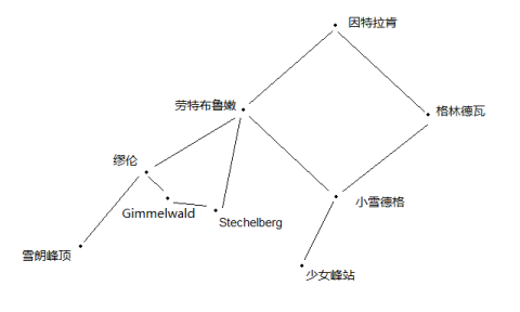
Here is a stream of consciousness sketch first, so that you can intuitively see the route map of the Jungfrau Region.
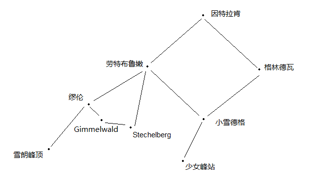
DAY 7 Interlaken → Lauterbrunnen → Murren → Schilthron → Stechelberg → Lauterbrunnen → Interlaken
There are three places where you can see the Jungfraujoch from a distance.
1. Hohermatte, the central lawn of Interlaken.
2. Harderkulm, the peak of Harder Mountain on the north side of Interlaken, is generally translated as Harderkulm, but I have to complain. Although I don’t know German, after a week in Switzerland, I know that kulm means peak orz, so this The place name is more appropriately translated as the top of Hard Mountain.
3. Schilthorn, another peak located on the west side of Jungfraujoch.
Since the weather was still cloudy on the first day in Interlaken, the Jungfraujoch could not be seen nearby, so we chose to go to the Schilthorn first to try our luck above the clouds.
In addition to the 360° observation deck where you can see the Jungfraujoch, another feature of Schilthorn is that it was once the filming location of the 007 series. I later checked and found that the film shot on the Schilthorn Peak was the sixth part of the series "On Her Majesty's Secret Service" or translated as "The King of Steel". It was filmed in 1969 and starred George Lazenby. He is a Bond actor, but this movie has a very bad reputation. I have also made up for it. Not only is the story not good, but in the end, Bond gets married first, and then the heroine is killed. In the end, Sean Connery was replaced in the seventh part, and the story of this part was silently erased.
Okay, without further ado, the journey begins.
0805-0825, Interlaken → Lauterbrunnen
After getting off the train in Lauterbrunnen, you need to take the cable car first and then change to the rack train to get to Murren. Although the departure time is very tight (only 3 minutes), the cable car station is right next to the train station in Lauterbrunnen, which is very convenient. Easy to find. He ran towards Murun without stopping.
0828-0851, Lauterbrunnen→Murren
Mürren (also known as Mürren) is a small town built halfway up the mountain. The cable car and rack rail are also seamlessly connected, making it easy to find. Murren is also a pollution-free town and all motor vehicles are prohibited.
From Mürren train station to the cable car station of the Upper Schilthorn, it is no longer a seamless connection but requires walking, and it is not short. It takes about 10-15 minutes to walk across the entire town, but this walk Never boring.

There is a main road with some wooden houses scattered here and there. This is basically the whole picture of the town. Placing some flowers on the windowsill may be a habit of most small town people
I also took a photo of a very cute sign.

At this time, the top of Jungfraujoch is slowly opening its eyes, a good sign!
910-927, Murren → Schilthron
Tickets for Schilthorn are 40 Swiss francs discounted. During the climb to the top, we also had to change cable cars. There was a big thermometer on the transfer platform, which told us that the temperature at the transfer station was - 0°C, which was freezing again.
After passing through the clouds, we arrived at the Schilthorn Observation Deck. At that time, the three peaks including Jungfrau were still tightly wrapped by the sea of clouds. But other mountains that I didn’t remember after reading the sign have already appeared above the white clouds.

After we took some random photos and bought some souvenirs. Jungfrau began to reveal itself.

From left to right: Eiger, Monch, Jungfrau
Even though it was backlit, even though the white clouds gave us only about 10 minutes of opportunity, it was enough to surprise us... for a little while. Since the weather was still not very favorable, we chose not to stay on the mountain for too long and went down early.
Tips
When the sun shines, even though the top of the mountain is below zero, it is not very cold.
1103-1120, Schilthron→Murren
Returning to Murren, I found that there is a highland on the east side of Murren with a particularly good view, overlooking the entire canyon near Lauterbrunnen.

In the small town of Murren, the exposed snow-capped mountain is the Eiger.
There are also a lot of people paragliding here. Those with money can give it a try. One jump with the guidance of a coach costs 160 Swiss francs, about 1,000 RMB.

We chose a small shop for lunch, where a group of old men and women who were drinking were sitting and chattering. The waiters were not very enthusiastic, the whole atmosphere was a bit lazy, and the food was so-so. There was a sausage platter nearby and ribs in the distance. A total of 51.8 Swiss francs.

The value of the view of the shop far exceeds the meaning of the food.

In such an atmosphere, the sparrows in the shop have become the scenery.

1230-1250, Murren→Stechelberg
After eating and drinking, we went down the mountain. In addition to the cog rail, Mühren also has a cable car. After transferring in Gimmelwald, you can reach the bottom of the canyon. From the cable car, you can see the canyon very clearly and the obvious glacial landforms.

If there were fewer clouds and the sun was shining, I think it would be more beautiful.
1306-1317, Stechelberg → Trummelbachfalle
There are many waterfalls in the Lauterbrunnen Gorge, the largest of which is the Tumebach Falls. Buses stop between Stechelberg and Lauterbrunnen. On the way to the scenic spot, you can hear the sound of the waterfall in the distance. Lauterbrunnen means "loud pool", maybe it comes from this waterfall.

Tickets for the waterfall cost 11 Swiss francs. There is an elevator that can go directly to the middle section. It is recommended that you take the elevator, because there is nothing interesting from the bottom to where the elevator is, and the good things have to go up. The waterfall passes through the mountains, and the Swiss have also built a trail on the side. It is a bit dark inside and the sound of the water is very loud. As long as you see the waterfalls, there are all kinds of rapids...it's quite shocking.
1417-1425 Trummelbachfalle→Lauterbrunnen
Return the same way and prepare to return to the city. You can also see a waterfall on the way - Staubbachfalle. This waterfall is characterized by a very large drop, and the water droplets float in the air to form mist. And to see this waterfall, I think the best place is not under the waterfall, but It's in the town of Lauterbrunnen. The solitary waterfall is far less spectacular than the wooden house that sets it off.

1503-1524Lauterbrunnen→Interlaken
For dinner in Interlaken, I originally planned to go to Hooters. I saw another store on the way and it looked okay, so I went in. When I walked in, I found someone playing the piano inside. I immediately felt that the price was going up, and I thought the price would also go up. Keep rising. In the end, I found that it was okay, a total of 82 Swiss francs, a veal, a fried potato rice bowl with shredded pork (heavy fog), and a soup. Basically, the average price of what we ate was a little higher. However, I don’t know what the vegetables that came with it had a strange smell, so I didn’t touch it. The waiter also said “do not like vegetable?”. I wanted to say that I didn’t think it was vegetable.
Tips
Although I accidentally took the route up to Murren on the cog rail and down to the cable car, I highly recommend this route. According to this route, you don’t need to go back to Tumebaha Falls, and the time is easy to control. If you go to the waterfall first and then go up the mountain by cable car, you may be too late.
DAY 8 Interlaken→Grindelwald→Kleine Scheidegg→Jungfraujoch→Interlaken→Montreux
That day may be the most important day of the entire trip, and the highlight is the Jungfraujoch Station, the highest railway station in Europe with an altitude of 3,454 meters.
0735-0809Interlaken→Grindelwald
Interlaken departs for Grindelwald and Lauterbrunnen at 05 and 35 minutes every hour. The carriages in the two directions are connected at first and separate at Zweilutschinen. There are waterfalls in Lauterbrunnen and glaciers in Grindelwald. If you need it, be careful not to take the wrong seat.
After arriving at Lauterbrunnen or Grindelwald, you need to change trains. After that, it is a private railway, so the Swiss Pass cannot be used and you need to pay extra. The original price of a round-trip ticket to Jungfraujoch is 162 Swiss francs (in 2016). If you hold a Swiss pass, it is 138 Swiss francs, which is equivalent to more than 800 RMB. It is the most expensive attraction in Switzerland. It is said that Swiss locals also think it is extremely expensive.
In the end, the destination of changing cars is the same, Xiaoxue Dege.
0817-0849 Grindelwald → Kleine Scheidegg
After arriving here, we have arrived at the real starting point of the Jungfrau Railway. Along the way, we can see the distinct scenery of grassland, woodland, wasteland and snow. Coupled with the white clouds lingering in the valley, it is like a fantasy.

0900-0952 Kleine Scheidegg → Jungfraujoch Station
If you forgot to buy a ticket before, you can make up the ticket on the bus to Xiaoxue Dege or in Xiaoxue Dege. Since we didn't read the guide carefully, we forgot about orz. The fare replacement on the bus can only be paid in cash, Xiaoxue Dege can pay by credit card.

From Schödergg, you can clearly see the Jungfraujoch. In the picture, Mönchberg is on the left and Jungfrau is on the right. The (almost invisible) building pointed by the arrow at the middle col is Jungfrau Station.

Close-up of the Jungfraujoch on the road, I think it requires a certain amount of imagination to see the girl.
Looking back at the bottom of the mountain, I was shocked.

There are 5 stations on the Jungfraujoch Railway, namely the Kosnowdegg 2061 meters, the Eigergletscher 2320 meters, the Eigerwand 2865 meters, the Eismeer 3160 meters, and the Jungfraujoch station Jungfraujoch 3454 meters.
After passing the Eiger Glacier, the train entered a tunnel dug out of the mountain. From the Jungfrau Railway, you can fully see the German spirit of the Swiss in order to develop tourism resources and facilitate tourists to save effort. After boarding the Jungfrau Railway, I felt that the expensive fare made sense, but it didn’t affect me and I still felt it was too expensive.
The Eiger Wall and Binghai stations each stop for 5 minutes for tourists to take photos. Looking at the snow-capped mountains through the glass on the rock wall is actually just average...

Glacier seen from Binghai Station
It took about 50 minutes for the train to reach Jungfraujoch, and finally arrived at Jungfrau Station at ten o'clock.
Among the Jungfrau group, Eiger is 3970 meters above sea level, Monch is 4107 meters above sea level, and Jungfrau is the highest at 4158 meters.
Every time I climb a mountain, I always marvel at the Swiss spirit of creating a world on the top of the mountain. Jungfrau Station is the same as all previous peaks from Pilatus to Schilthorn. There is almost everything on the top of the mountain. There are restaurants (usually one restaurant and one buffet, the buffet is slightly cheaper), souvenir shops, hotels (Jungfrau seems to have none), and even watch shops and chocolate shops. I always get drunk when I see all this when I get to the top of the mountain. I feel that the top of the country is so backward, so the business situation of the top of Mount Tai can be compared.
The tour route at Jungfraujoch Station is also very well planned. You can walk through all the attractions by following the signs (it’s actually not much). There is a viewing platform (Sphynx Observation Deck) at the beginning. You can see the Jungfraujoch and the Eiger from the platform, but it is relatively small and you can't touch the snow. Although the field of view is okay, with all kinds of cables, I can't always take clean photos.


From left to right: Monk Peak (east), Alps (south), Valley (north).
Then there is the ice cave. The so-called ice cave, like Mount Titlis, is a hole drilled by the Swiss in the glaciers that have not melted for thousands of years on the Jungfraujoch. In short, I will worship the Swiss people's efforts for tourism at the top of each mountain. It is said that due to the slow movement of glaciers, the ice cave must be dug again every N years.
Finally, there is an outdoor activity place where you can step on the snow. Jungfrau and Monk Peak feel close at hand.

Let’s talk about Jungfrau here. It is said that the reason why it is called Jungfrau is that it looks like the side face of a supine girl. I still think this matter is the same as horoscopes, it all depends on imagination.
The Monk Peak that seems to be right in front of you actually has a drop of 650 meters.

Glaciers on the south side, and the Alps.

Tips
1. The Jungfraujoch Station is very high, so you should pay attention to the high altitude and don’t exercise too much.
2. The snow outdoors is slippery, so wear non-slip shoes and be careful when walking.
Lunch is still a buffet.
Ahem, it's not very tasty, and hot water costs money, and it's very dark.
To go down the mountain, you need to go back the same way (if you haven’t gone to Schilthorn and are coming from Grindelwald, you can go back from Lauterbrunnen).
I actually like this scene very much.


I don’t know if after many years, I will change from a humanities party to a landscape party. After all, seeing too many humanistic things, such as small towns in Switzerland or stone temples in Cambodia, can easily lead to aesthetic fatigue, but landscapes are basically not.

The Swiss cows photographed on the road, Swiss cows and bells are their iconic items and can be found on many souvenirs.
1300-1524 Jungfraujoch Station → Interlaken
After returning, we saw that the weather was good, so we took the risk of arriving at the next stop in the middle of the night and forced ourselves to visit the remaining two holy places overlooking the Jungfraujoch, starting with Harderkun. The Swiss Pass is free.
1555-1605Interlaken→Harder Kulm
Harderkun is located on the north side of Interlaken. Since there is a mountain pass just south of Interlaken, Jungfrau is partially exposed from the mountain pass, so the condescending Harderkun is an excellent viewing platform. The persistent Swiss once again built a rack train and restaurant on the top of this mountain...

The Jungfraujoch seems to be imposing and majestic when viewed up close, but it feels more tranquil when viewed from a distance, like a virgin standing gracefully in the distance (imagine, remember imagination).
A panoramic view can completely see Interlaken sandwiched between two lakes, looking up at the Jungfraujoch.

Hardquan is also a paragliding holy land. I think it looks quite beautiful from this angle.

1645-1705 Harder Kulm→Interlaken
Finally, we rushed non-stop to the central lawn of Holhemat (the approximately square lawn surrounded by the small orange patch in the center of the panorama). It is said that Hohemat was originally a monastery. Because of the good view, it was demolished and turned into a square, and no more buildings were allowed to be built.
I think after using my imagination, I can still imagine this angle. The highest point is the girl's forehead, the right side is her long hair, and the left side is her eyes, nose, and mouth. The imagination is complete.

Tips
1. The cable car in Hardequin runs every half hour, and the time at the top does not need to be very long, so pay attention to calculating the time.
2. It is recommended to stay one more night in Interlaken. Since we only had two nights, we did not go to the Grindelwald glacier. Staying for three nights will be helpful for adjustment. If you have more time, leave Interlaken in the morning. When you arrive in Montreux, if you have enough time, you can visit Chillon Castle.
We had to change our accommodation that day, and it was not close. I had expected that we would arrive quite late, but I didn’t expect that there would be some twists and turns.
1729-1750Interlaken→Speiz
1818-1859 Speiz→Zweisimmen
1926-2111 Zweisimmen→Montreux
If you go from Interlaken to Montreux, you can take the scenic train Golden Pass Express and transfer once at the Zwies Gate. The whole journey takes a little more than 3 hours. SBB and the timetable app both recommend another route, which is to go to Spiez first, then transfer to Visp, and then transfer to Montreux. Although it takes two transfers, it only takes about 2 and a half hours.
Because the scenic train is not very special, we took the bus to Spiez first, and then found that there were many people waiting on the platform to go to Visp. After listening to the announcement, it was that the shuttle bus was cancelled. I really encountered everything...because It was difficult to judge the subsequent trains, so we changed to the train to Zwais Gate. We originally planned to arrive at Montreux at 8 o'clock, but finally arrived at 9 o'clock.
Again, I highly recommend staying in Interlaken for three nights! Then it is best to set off from Interlaken to Montreux during the day, especially if you plan to take the scenic train, because it is dark at night and you cannot see any scenery. In Switzerland, the words "scenery on the road" are very precise.
Since it was too late, I bought some dinner at the supermarket in Montreux that day.
DAY 9 Montreux→Zermatt→Gornergrat→Zermatt→Montreux
The last stop of the Alpine journey is the Matterhorn, which should be called the Matterhorn (Mat-thorn) to be precise. The Matterhorn is on the border of Switzerland and France, with an altitude of 4,478 meters. The entire mountain peak is in the shape of a four-sided cone, which is very distinctive. Swiss Toblerone is named after him. Zermatt at the foot of the mountain is the starting point for climbing.
0842-1113Montreux→Zermatt
The bus from Montreux to Zermatt requires a transfer at Visp or Brig, which takes 2 and a half hours. The Matterhorn itself is unreachable because it is higher and steeper than Jungfraujoch, but there are three viewing spots. The best ones are Gornergrat, Klein Matthorn and Sanne. In addition to Sunnegga, since we arranged a day trip, we went to Gnerath.
The Matterhorn is so high that it can be clearly seen from the town of Zermatt.

1136-1209Zermatt→Gornergrat
The cog rail station is right next to the Zermatt train station and is very easy to find. The round-trip ticket is 43 Swiss francs per person after discount.
The Gennerat rack train is the oldest rack railway in Switzerland. I think this marks the origin of the Swiss who worked tirelessly to build train tracks into the mountains! The climbing angle of general railways is about 6° at most, while the maximum climbing angle of a rack train is 48° on Mount Pilatus. The place with the most cogwheel trains in the world is in Switzerland...
I feel that there may be a difference in climate between the Matterhorn and Jungfrau. When I get here, I feel that there is a lot less green vegetation. The snow line and the middle of the forest are all yellow grass.

The train stops at 5 stations and you can get on and off at any time. It runs every 24 minutes.
Matterhorn close-up.

After taking pictures, let’s eat first. There are still hotels, restaurants, souvenir shops, etc. on the top of the mountain.
The buffet here is quite conscientious, one chicken, 4 meat skewers, 4 pieces of fried chicken, and 2 more meat skewers at the end, totaling 40.3 Swiss francs. There was a little girl from Hangzhou who was traveling alone and shared some of the salami she brought with us. The raw prosciutto was not delicious, really... It is also worth mentioning that they didn't ask me for money when I wanted hot water here! Jungfrau is so confusing.
Among all the photos of the Matterhorn, I think this one I took is the most artistic.

There are glaciers behind the mountains, and they all look the same, so I won’t show them in the picture. But there is one picture that I must put up to express my last admiration for the Swiss railway people.

One stop away from the train, you can walk to the Liffel Hill (a large rock) and the Liffel Lake (a small pond). You can see the reflection of the Matterhorn in the Liffel Lake. The pond looked very dilapidated, and it turned out to be a lie after taking photos.

1618-1705 Gornergrat→Zermatt
1713-1952 Zermatt→Montreux
At this point, the climbing trip is all over, and the weather is good at the end, which makes me very satisfied.
Dinner was once again made from paste at the supermarket.
Tips
If you want to visit various viewing spots near the Matterhorn, one day is not enough. It is recommended to stay in Zermatt.