
Here is the thrilling carving slowly with time,
It is God's work.
——U.S. President Roosevelt
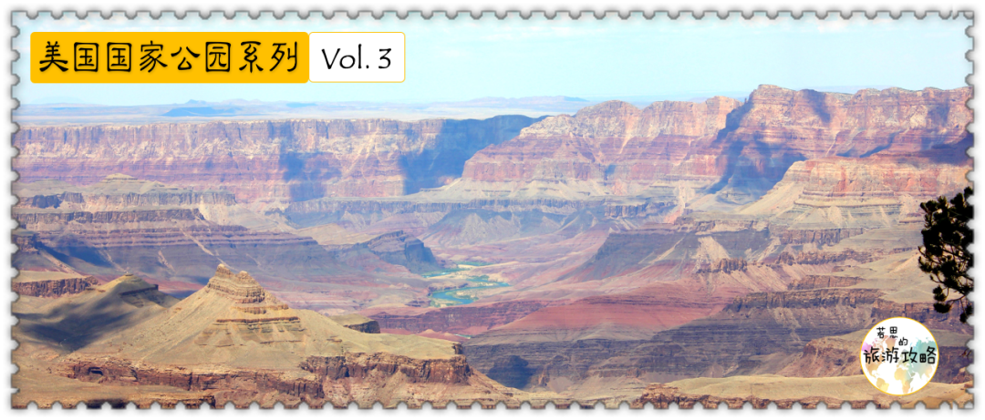
The Grand Canyon, also known as the Grand Canyon of the Colorado, is a World Natural Heritage Site determined by UNESCO and one of the seven natural landscapes in the world. But it's actually located in Arizona, not Colorado. It’s just that it is located on the Colorado Plateau, hence the name Grand Canyon. Arizona is also nicknamed the "Grand Canyon State" because of its Grand Canyon. It should be noted that the Grand Canyon and the Grand Canyon National Park are two different concepts - the entire Grand Canyon is 446 kilometers long, 29 kilometers at its widest point, and 1,800 meters deep at its deepest point. In 1919, the U.S. Congress passed a bill that officially The deepest and most spectacular 170 kilometers of the Grand Canyon were designated as the Grand Canyon National Park , and is managed by the National Park Service. The part that is not included in the national park is managed by the Hualapai and Havasupai tribes. For example, the Grand Canyon Glass Bridge, which has become famous in recent years, is in an area managed by indigenous people and is not part of the national park. On the way into the Grand Canyon National Park, you will often see stalls set up by indigenous people, offering to take you to see the Grand Canyon for a fee - this is indeed the Grand Canyon, but it does not belong to the Grand Canyon National Park. The trend of the Grand Canyon follows the Colorado River - the Grand Canyon cut by the ninety-eight meanders of the Colorado River is also zigzag, but generally runs east-west.
The yellow part in the picture below is the Grand Canyon National Park, and the purple part is the Indian reservation:
Ordinary people cannot go deep into the depths of the Grand Canyon. What they browse is just the blue dotted line in the picture above. This part is enlarged as follows: As you can see, the park is divided into the South Rim and the North Rim. The two are not directly connected. It takes several hours of driving to go around the other edge from outside the park. 90% of tourists go to the South Rim, which is better developed, has more scenic spots, and has more convenient transportation. There is only one main road in the park, and most of the viewing spots are along the main road, making it difficult to get lost. How was the Grand Canyon formed? This story begins 2 billion years ago, when igneous and metamorphic rocks were formed. In the next 2 billion years, new rock layers were continuously formed. This is the origin of the layer-cake-like appearance of the rock walls of the Grand Canyon today. However, the uppermost rock of the Grand Canyon is Kaibab limestone - a rock that should theoretically be formed on the sea floor. How did it reach the top of the Grand Canyon at an altitude of 3,000 meters? Scientists believe that between 70 million and 30 million years ago, the entire region was lifted from the ocean floor due to plate tectonics, creating the high, flat Colorado Plateau, which gave the Colorado River a plateau to harvest. However, scientists still don't understand how the Colorado Plateau rises, which is generally accompanied by rock deformation. Here, however, the entire plain is lifted high, and the rock remains unchanged. More mysteries remain to be researched and verified. PS: There are many types of valleys, including rift valleys formed by tectonic plates and valleys formed by glacial abrasion, but the most common ones are canyons cut by water flow. A canyon refers specifically to a valley formed by long-term erosion by rivers.The Grand Canyon is the best example of a water-carved canyon. The Colorado River has been carving this area for the past five to six million years. During its 446-kilometer journey through the Grand Canyon, the Colorado River drops approximately 610 meters in height. This is a very steep slope, and the water rushes downstream under the influence of gravity. The flow of the Colorado River itself is not large, only 15,000 cubic feet per second, which is much lower than the Mississippi River or the Nile River. However, during floods, its water volume suddenly doubles, carrying a large amount of sand and gravel rolling down, unstoppable, like a sharp knife. Split the rock. Some geologists believe that at the end of the last ice age, melting snow in the Rocky Mountains formed a torrent of up to one million cubic feet per second, carving out mountains and valleys. Most of the scenic spots in the Grand Canyon should actually be regarded as observation decks, allowing you to take pictures of the Grand Canyon from different angles.
Most of the scenic spots are along the main road. If you see a fork in the main road suddenly and everyone is queuing to turn: don't hesitate, it means that the observation deck is gone. The reason why the two accommodation places in the picture above are also marked is because the scenery at these two places is really good, not inferior to the observation deck. However, please note that all the places marked in the above picture are accessible by car, except Ghost Villa . Ghost Mountain Villa is located at the bottom of the valley, with beautiful scenery, but there are only three ways to go: hiking, riding a donkey, or rafting along the Colorado River. However, most of the scenery taken from different viewing platforms are similar because they are all viewed from above. The only difference is that some observation decks can capture the Colorado River, while others cannot. If you want to see the unique side of the Grand Canyon, you must go deep into the canyon. There is only one way here - hiking.
Time required: If you just take photos on the observation deck, you can visit this park in only 1 to 2 hours. However, seeing the majesty and majesty of the Grand Canyon, it is difficult for anyone to resist the temptation not to hike. The time for hiking is uncertain. Some people choose to spend 1-2 hours walking, take a few photos and then turn back; others choose to spend a few days hiking here.
Click on the topic #Grand Canyon above the article. More Grand Canyon extras will be released soon, including 18 hiking routes in the Grand Canyon and my hiking story. Hiking route Most people hike on the South Rim. There are 5 hiking trails here. The following 3 are more recommended: 1) Rim Trail/edge trail Starting point: South Kaibab Trailhead End point: Hermits Rest Length: 21 kilometers one way , but there are many entrances and exits along the way, and they are all near the shuttle bus station. You can choose to enter or exit the hiking trail at any stop. Difficulty: Easy, there is shade along the entire route, and the path is flat and well-groomed. However, drinking water will not be provided throughout the journey. 2) Bright Angel Trail/Bright Angel Trail Starting point: Bright Angel Lodge End point: Phantom Ranch Length: 16 kilometers one way, but few people walk the entire distance. Most people only walk the first 5 kilometers and return the same way. It is recommended that you only go as far as Indian Garden (8 kilometers one way) and then turn back. Difficulty: Moderate, relatively steep, with an altitude drop of 1,000 meters and no shade most of the time. There are only a few water points throughout the journey. Note: Personally, I think Bright Angel is the most scenic hiking trail. I also bumped into a deer while hiking PS: I was hiking in a temperature of nearly 100 degrees, and I woke up at 4 or 5 o'clock in the morning, so I seemed to be in quite bad condition... 3) South Kaibab Trail/South Kaibab Trail Starting point: Yaki Point End point: Phantom Ranch Length: 12 kilometers one way, but few people walk the entire distance. Most people only go to Cedar Ridge (2.4 kilometers one way) or Skeleton Point (4.8 kilometers one way) and return the same way. Difficulty: Moderate, relatively steep, with an altitude drop of 1100 meters and no shade. There are no drinking water points throughout the journey. The scenery is different from that of Bright Angel. The style here is tougher and more suitable for taking some more hard-core photos, such as this: The 18 hiking routes in the Grand Canyon will be published soon in the topic #Grand Canyon, so stay tuned . There is another way to hike in the Grand Canyon: RIM-TO-RIM, that is, edge to edge: go down from the rim of the Grand Canyon to the bottom of the Grand Canyon, the Colorado River , and then turn back from the bottom of the valley To the rim of the Grand Canyon.
Due to the extreme heat here, it is very difficult to reach the bottom and back in one day. It is best to spend two days to complete it, and stay overnight at the Ghost Mountain Villa or Bright Angel Campground at the bottom of the valley. In fact, the official website of the Grand Canyon reads: Under no circumstances should you attempt to hike from the rim to the river and back in one day! Do not hike during the hottest part of the day. Under no circumstances is it allowed to challenge RIM-TO-RIM within one day. If you are interested in RIM-TO-RIM, you can read my hiking story, which will be posted on the topic #大 Canyon中 before the end of March. The North Rim of the Grand Canyon is 300 meters higher than the South Rim, so the snow is thicker in winter. It is only open in summer, and the natural environment remains relatively primitive. The South Rim is open all year round, and more than 90% of tourists go there. South Rim. According to statistics, there are more than 4 million visitors here every year.
PS: The plank road on the south edge may be closed due to slippery snow in winter, so you can only take pictures at the viewing point.
There are several airports near the Grand Canyon: Phoenix Airport (PHX), Las Vegas (LAS), Flagstaff (FLG), Prescott (PRC), Sedona (KSE2), and Grand Canyon Airport (GCN). Among them, only Las Vegas and Phoenix can be considered big cities. The rest are very small airports. There are no direct flights in the United States. You can only fly to a nearby large airport and then transfer. PS: Although Salt Lake City Airport (SLC) is relatively far from the Grand Canyon, many people choose to visit nearby national parks, which is closer to Salt Lake City. 2. Public transportation There is no train station near the Grand Canyon. The nearest train station is Flagstaff or Williams Station. There is a shuttle bus from Flagstaff to the Grand Canyon, and the transportation is relatively convenient. There are also many tour buses to the Grand Canyon from Las Vegas. The Grand Canyon is a national park that can be easily visited without driving. 3. Self-driving There are so many national parks near the Grand Canyon that it would be a pity to visit only one. If you want to visit multiple parks, self-driving is a better choice. There is a traffic artery on the South Rim and the North Rim each. 1) Self-driving Except for the red route in the map above, you can drive yourself in other places, but the parking spaces in the area covered by the shuttle bus are very limited, and the parking spots do not allow long-term parking, so you can drive by yourself if you just take pictures next to the scenic spot, but If you want to hike, you have to take the shuttle bus. 2) Shuttle Bus In order to solve the parking problem in the park, Grand Canyon National Park strongly encourages tourists to take shuttle buses . The shuttle bus fee is included in the national park entrance fee and there is no additional charge. There are 5 shuttle bus lines: The Grand Canyon encourages you to park your car at the visitor center and then take the shuttle bus. Parking at remaining attractions has time restrictions. For example, I met this unlucky guy when I was hiking at Yaki Point: Once the small yellow lock is locked, it is difficult to drive away without paying one or two hundred. There are not many accommodations in the Grand Canyon. Fortunately, there are many small towns around that provide accommodation and shuttle buses, which is very convenient. 1. Accommodation in the park Since the South Rim and North Rim of the Grand Canyon are completely separated, the accommodation chapter will also be divided into the South Rim and the North Rim—— View from the map: Note: 2. Accommodation outside the park Both the south and north edges are not remote. There are many small towns nearby, and there are also many motels, airbnbs and other accommodations along the highway. The small town of Tusayan is just outside the south gate of the park. There is a shuttle bus directly to the visitor center, making accommodation very convenient. Most people regard the Grand Canyon as a stop on the Grand Loop, and choose to stay along the Grand Loop. In addition to big cities like Las Vegas and Phoenix, there are many small towns along the Loop. You can find a lot of accommodation on websites like hotels.com.


