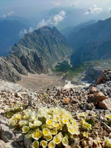
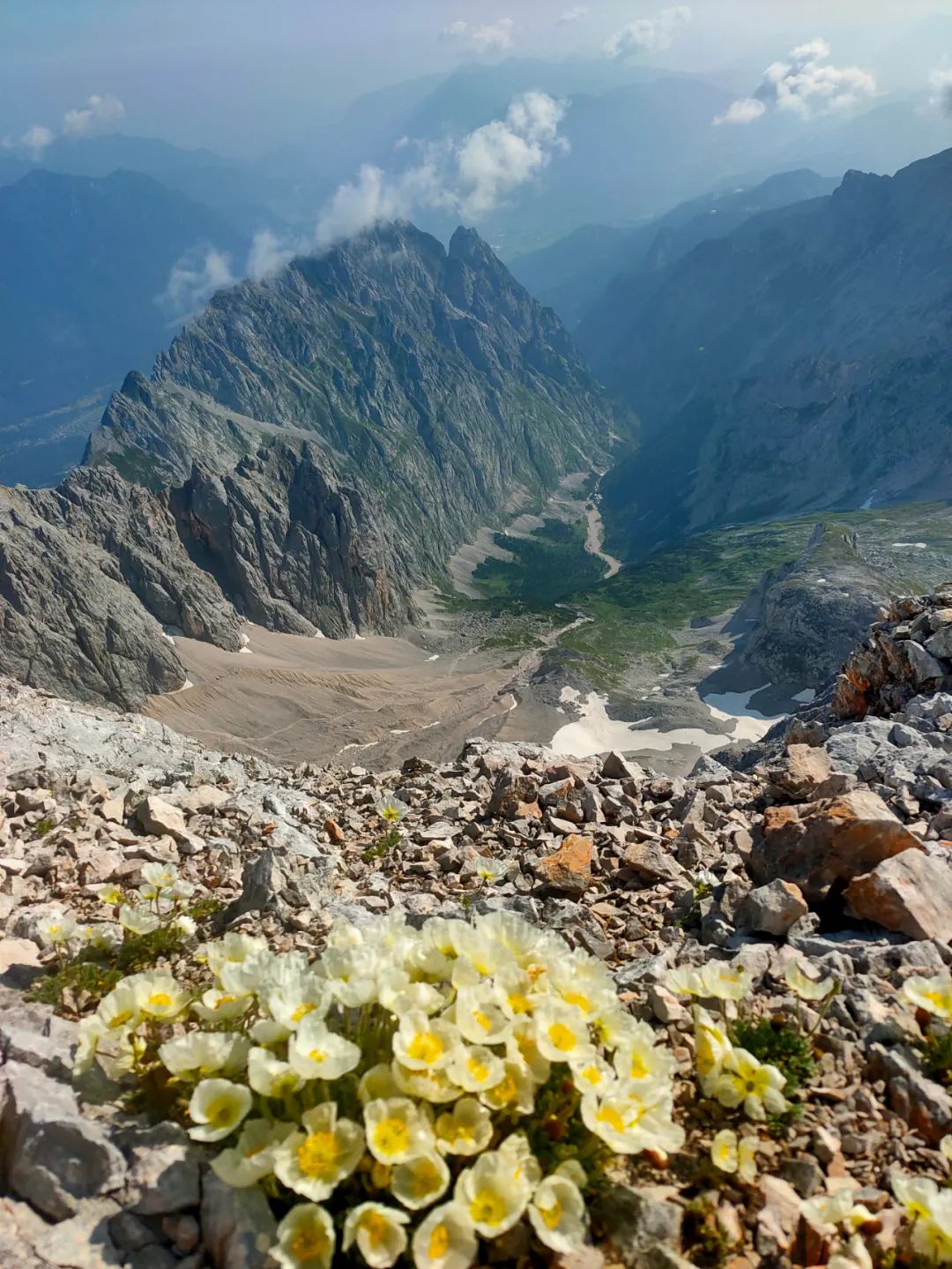
Pictured: Wildflowers blooming on the ridge near Zugspitze
July 22, 9:37 in Garmisch-Partenkirchen, Bavaria, Germany
The Alps, which stretch for 1,200 kilometers, left behind majestic peaks as they passed through southern Germany - the Bavarian Alps. The highest point of this section of the limestone mountains is the Zugspitze with an altitude of 2962 meters, which is also the highest point in Germany (located at the border of Germany and Austria). There is a cable car that goes directly to the top around the top of the mountain. There are a number of wooden cabins that provide catering and accommodation in the mountain, as well as hiking routes to the top in multiple directions. It attracts a large number of tourists and hikers every year. During my first summer in Europe, I finally had the opportunity to step into the Alps, and hiking the Zugspitze was an attractive start.
There are five hiking routes to the summit of Zugspitze, namely
Route A is along the valley, the longest and easiest route; Route E is entirely on the ridge, is the shortest route, is also the most difficult and dangerous. Routes D and E involve technical climbing and require via ferrata (via ferrata) protective equipment. This time I plan to climb to the top from route B to enjoy the scenery of Zugspitze, and then take route E to experience the broad view on the ridge. This will be my first hike in the Alps and my first via ferrata experience.
Table of contents
01 Cross the German-Austrian border and stay overnight at the Knorr cabin
Route B to climb the Zugspitze starts from the small town of Ehrwald in Austria, crosses the mountain pass on the German-Austrian border, and overlaps Route A at the Knorr cabin, and then starts from the cabin to climb the Zugspitze. The first day of the trip starts from the Ehrwalder Almbahn cable car station and arrives at the cabin for one night. According to the road signs, it is estimated that it will only take 4 hours, and the altitude climb will be from about 1,500 meters to about 2,000 meters, which is very easy. So I waited until about 12 noon before I started hiking from the cable car station.
This journey can be divided into two parts: from the starting point to the mountain pass on the German-Austrian border and from the mountain pass to the Knorr cabin. The former cuts along the south side of the Zugspitze and is in Austria; the latter crosses the ridge on the German-Austrian border and is in Germany.
▼ The first day’s itinerary, from the cable car station to the Knorr cabin, crossing the mountain pass on the German-Austrian border (the black line along the ridge in the picture is the German-Austrian border)


▼ The winding path on the left leads to the mountain pass on the German-Austrian border


▼ Surrounded by barbed wire is the German-Austrian border. The barbed wire once played a role, but now it is just a place to take photos and check in.

▼ The two peaks at the German-Austrian border pass are very impressive, because when you walk through the pass, you see a completely different scene. These two mountains seem to be guarded by generals.

After crossing the mountain pass on the German-Austrian border, you will see a completely different scene. In front of you is a large gentle slope, surrounded on three sides by the ridge of the Zugspitze, with an altitude of more than 2,000 meters. It is in an alpine desert zone, shrouded in clouds and mist all year round, and there is no fragrance. The grass is beautiful. The other side of the gentle slope extends into the valley, where you can have an unobstructed view of the winding paths, coniferous forests, and even houses. This is the Reintal Valley on route A. Along this valley and out of the mountains on both sides is the inhabited town of Garmisch-Partenkirchen.
▼ On the plateau surrounded by the Zugspitze ridge, meadows and a few low pine trees grow hard among the gravel.


▼In the Reintal Valley on Route A, the altitude gradually decreases along the valley, and forests begin to appear.


As long as you cross the mountain pass on the German-Austrian border, you can see the Knorr wooden house in the distance at the other end of the gentle slope. After trudging for a period of time among gravel and meadows, you circled from the south side of the canyon to the north side, and the wooden house also Finally close.
▼ On the north side of the canyon, there are many sheep grazing on this gentle slope.

▼ Knorr cabin is built on a mountain ridge on three sides and surrounded by the canyon on one side. Zugspitzplatt plateau

It was not yet 5 pm when we arrived at the Knorr cabin. The sun sometimes peeked out from the clouds and mist and still gave off a strong light. Knorr wooden house sea level 2052 meters was built in 1855 by the German Alpine Club (German Deutscher Alpenverein, referred to as DAV) operates and can provide food and accommodation for climbers. Hiking routes in Europe are often very mature, with signboards along the way, and there are such uniformly operated mountain huts on many routes. Hiking is one of the most popular leisure methods in Europe. It has developed for hundreds of years and is now rapidly becoming popular in our country.
02 Climb the Zugspitze in the early morning
In fact, we had expected that today’s journey would be very long. It would take three hours from Knorr Chalet to the summit of Zugspitze, and then it would be another 7 kilometers of ridge route from Zugspitze to Alpspitze. According to the information online, it would take at least another 7 hours. Hour. I need to rush to the Alpspitzbahn cable car station before 5 o'clock to take the last cable car to the town of Garmisch-Partenkirchen, otherwise I have to spend the night in the mountains. So today I had breakfast at 5:40 and put on my backpack. I had already embarked on the route to the summit of Zugspitze. Looking back at the Knorr cabin in the mist, it was still quiet. I was sure that no one had set off earlier than me.
In summer, the sun rises very early in Europe. Today, we started walking on the Zugspitze Plateau. Zugspitzplatt plateau The sunlight was blocked by the tall mountains around. It was not until we reached a higher altitude that we realized that the top of the mountain had already welcomed the sunrise. The morning light slanted on the rock mass with occasional snow, instantly bathing it in a layer of golden red light, giving people a feeling of "sunlight on the golden mountain".

▼ Occasionally cross the snow

The gravel road for the first three kilometers starting from the cabin is not too steep, and we travel very fast. Sometimes we pass through snow and sheep, and the view gradually becomes wider and wider. There is a steep gravel slope one kilometer before Zugspitze. The difficulty is that the gravel is unstable and will slide when you step on it, which is quite physically demanding. Fortunately, it is not long. After another ascending route protected by iron cables, we finally climbed to On the ridge of Zugspitze, a strong wind immediately announced the majesty of the top of the mountain.
▼ The last section of cable before the Zugspitze cable car station

At this time, we were very close to the summit of Zugspitze. Along the ridge protected by iron cables, we arrived at the summit cable car station in a short while. There are actually two cable cars that lead from the foot of the mountain to the peak. The one in the north comes from Germany, and the one in the west comes from Austria. The cable car on this side of Germany rises from the foot of the mountain to Lake Eibsee (973 meters above sea level) to the top of the mountain. It maintains the largest cableway drop of 1945 meters, the longest single cableway span of 3213 meters and the tallest steel tower of 127 meters. Most of all, it has always been a project that the Germans are proud of.
▼ The golden cross on the top of the mountain on the left is the highest point of Zugspitze

▼ Overlooking Lake Eib at the foot of the mountain

▼ The Zugspitze Plateau we just walked through

From the summit cable car platform to the highest point of Zugspitze, you still have to climb the last ten meters, which requires the use of ladders. Not far from here is Lake Eib with a drop of nearly 2,000 meters. It is somewhat daunting, but the summit The golden cross still attracts many people to overcome this period of fear and achieve the true summit of Germany.

▼ View of the summit cable car platform at the highest point of the Zugspitze

For tourists who take the ropeway to the summit cable car platform, reaching the golden cross means reaching the summit. For hikers who want to take the Zugspitze Ridge Route, this is the first step. I rested for a while at the top of the mountain, packed my backpack and got ready to go. It was about 9 o'clock at this time. Even if we walked the remaining 7 kilometers for 7 hours, plus an hour's rest, we could reach the cable car station before 5 pm - at this time, I had no idea why this route was so fast. The expectations are much tougher.
03 Complete the Jubiläumsgrat ridge via ferrata route exhausted
JubiläumsgratRidge (Jubilee ridge)Route, extending along the ridge from the Zugspitze (2962 meters above sea level) to the Alpspitze (2628 meters above sea level), is the most famous in the Bavarian Alps. One of the via ferrata climbing routes. The highest difficulty of this route can reach D (the difficulty rating of the via ferrata climbing route is from A to F, with F being the most difficult and D being very different), and the length of the ridge route reaches 7 kilometers, which is very physically demanding. The entire route is on the ridge, with Höllental on one side and the Reintal valley on the other side. The feeling of exposure is very strong.
▼ Zugspitze Jubiläumsgrat via cable climbing route map (picture from www.bergsteigen.com)

▼ The route of the ridge from the Zugspitze summit to the Alpspitze in the picture below is Jubiläumsgrat

I found some reviews about this route on the Internet, which mentioned that it is "incredibly dangerous", and that this route is more climbing than walking. Some sections are not even via ferrata climbing sections - but lack of Sections of road protected by iron cables. Despite this, we could still see figures on multiple ridges at the top of Zugspitze that day.

This route starts with a descent from the Zugspitze along the ridge. It is not very difficult and does not require the use of protective equipment for via ferrata climbing. Standing on the ridge, looking down at both sides, one side is Hell Valley, the other side is the Zugspitze Plateau , looking to the south is countless Austrian mountains.
▼ Hell Valley seen from the entrance of the cave

▼ Not far from the Zugspitze, a panoramic view taken on the Jubiläumsgrat ridge . The Jubiläumsgrat ridge with the iron rope in the middle is the Jubiläumsgrat ridge. On the left side of the ridge is Hell's Valley (also known as Route D). On the right side is the Zugspitze Plateau covered with snow. In the distance of the plateau is the ridge that forms the border between Germany and Austria.
Please view horizontally

The hour or so walking along the ridge was relatively smooth, and we still had the opportunity to appreciate the heights of the mountains and the depths of the valleys. However, as the route progressed, unfavorable conditions began to appear. First, I lost my sunglasses while hiking the Twin Lakes in Austria the day before yesterday and didn’t have time to buy them. The gray limestone on the ridge reflected the strong sunlight, and my eyes began to burn to tears. I couldn't even open my eyes when I got to the back, and could only squint intermittently to look at the road and the screen of my phone. Second, the drinking water was immediately consumed. Being exposed to the sun on the ridge, and gasping for air while climbing, I felt thirstier than usual. The water consumption during this journey was more than expected , my 0.5L drinking water was consumed by noon (In order to minimize the weight when climbing, I only brought the appropriate amount of water when I set out) . This seven-kilometer ridge route went much slower than I expected.
▼ There are also some climbers on this road, and some are traveling very fast.


In fact, the walking speed on the ridge section is still not slow. What is very time-consuming is the continuous ascent and descent between huge mountains along the via ferrata rock climbing route. The further we go, the more routes there are like this. I originally hoped to cover one kilometer in an hour, but the 300 meters section with a lot of climbing took an hour.


After climbing for a long time, the track recorded on the phone has not moved much. It seems that I am trapped in one peak after another. I don’t know how many such peaks are waiting on the ridge ahead. Because there was no water and food at noon, my physical strength began to decline significantly, but the more difficult part was yet to come.
The clouds and mists in the mountains changed erratically, and suddenly a heavy fog shrouded the ridge. Instantly, the deep valleys on both sides were submerged in a vast expanse of white. I could only see the ridge within tens of meters in front of me (of course, the advantage was that I Your eyes feel more comfortable and the sun is no longer dazzling). At this moment, an almost vertical mountain seemed to suddenly appear in front of us. It was impossible to see the bottom from both sides in the heavy fog. I was wondering if there might be red markers around indicating a way to descend to the bottom of the valley and bypass the peak, or to follow the peak and cross over. When I looked up, I was surprised to find an iron cable extending straight to the top of the rock wall - this meant that this route was to climb up rather than go around the mountain. In my mind came the image of the comic book "Liao Zhai" that I read when I was a child - the protagonist was trapped on a mountain peak in a dream and could not go up and could not go down, just like the mountain in front of me Similar.
▼ In the enlarged pictures below, you can see that the iron cables attached to the rock wall are extending towards the top of the mountain. This is the most difficult part of this iron cable climbing route.


With the protective equipment for via ferrata climbing, plus steel handrails and iron cables, completing this via ferrata climbing route is not that difficult compared to sport climbing. Compared with the difficulty of this section of the rock wall, the more direct test was my physical strength, because at this time I was already hungry, thirsty, and somewhat exhausted. But there was no way out at this point, so I kicked under the rope and tried to climb up the rock wall in one go.

▼ Via ferrata climbing uses protective equipment to connect the safety belt and the iron rope together to ensure safety, but there are no iron ropes in some dangerous locations on this route.


I am really grateful to the school for providing rock climbing courses during my graduate school years, as well as my rock climbing teacher. The rock climbing techniques taught in the class played a big role -Use your feet as much force as possible for every step up, rather than relying on your hands to pull your body up. This can save a lot of energy. .
▼ The stone-enclosed shelters we passed along the way

Finally, we emerged from the most difficult section in the thick fog, and the last peak on the ridge was the Alpspitze. On the last climb, I was almost out of breath and climbed ten meters to rest for a while. This climb of more than 100 meters, after countless stops, finally reached the last high point of this ridge - next to an iconic cross on the Alpspitze at an altitude of 2620 meters. From here, you can see the foot of the mountain. town. At this time, the last goal was finally achieved, and I was relieved. The time has reached 19:43 in the afternoon, and the cable car station has closed, but no matter what, we have to continue descending to the cable car station.
From the top of the Alpspitze to the Alpspiztebann cable car station at an altitude of 2050 meters, there is a descent of nearly 600 meters. This is the Alpspitze-Ferrata route. Many of them are composed of steel handrails and footrests. It is not difficult and is rated A/B. . Perhaps because I was exhausted, this section was longer than expected, as if there was an endless ladder.
▼ The iconic cross on the top of the Alpspitze

▼ Alpspitze-Ferrata via ferrata descending from Alpspitze to Alpspitzbann

Even though there are long days in Europe in July, I welcomed the sunset in the mountains until it got dark. Finally, at around 9 pm, I stepped off the last step of the via ferrata rock climbing. It would not be long to go. The mountain road leads to the cable car station. I have been walking in the mountains for almost 16 hours that day.
As feared before, the cable car station may not have any food and accommodation after get off work. I walked around the cable car station and didn't find a single faucet or vending machine, which meant that water and food would have to wait until at least tomorrow morning. Fortunately, there was a sleeping bag in my bag, and the temperature in the mountains would not be very low in summer. I spent the night in my sleeping bag under the eaves of the cable car station.
Finally the next morning came and I woke up very early. Waiting for the first ray of sunshine to emerge from the clouds, the first group of people climbing up the cable car, and the first sip of drinking water. After the cable car station opened at around 8 a.m., I bought a cable car ticket to go down the mountain and returned to the foot of the mountain. Then I used public transportation and finally returned to the hotel in Munich at 1 p.m.
▼ The iconic peak of Alpspitez

▼Finally returned to the small town of Garmisch-Partenkirchen

04 Route Summary
It was an exhausting, profound experience. The gray-white limestone of the Alpine ridges reflecting the strong sunlight, the towering mountains that look as real and illusory as in "Liao Zhai" in the mist, and the ridges with extremely wide views overlooking hundreds of peaks all left a deep impression on me. The Zugspitze Route is the representative of hiking in the Bavarian Alps, with both the painting-like beauty on the climb and the endless splendor on the ridge.
In terms of route difficulty, this ridge route from Zugspitze to Alpspitze Jubiläumsgrat is highly difficult, dangerous, time-consuming, has few descent points, and is greatly affected by weather. It requires a certain amount of time. Rock climbing technology and via ferrata climbing protection equipment, and the difficulty will be greatly increased under adverse conditions such as bad weather and lack of physical strength. It is highly not recommended to try this route without having similar experience. If you have some experience in rock climbing and hiking, you should be mentally prepared to try it. It is also recommended to consider it when planning.
Allow enough time. This ridge route can take upwards of 10 hours. It is recommended to take the cable car to the top of the Zugspitze, then complete the route in the direction of Alpspitze, and finally take the cable car down from Alpspiezbann to save time and energy.
Carry more water than you would normally expect. There are no water replenishment points along this ridge route. In sunny weather in summer, water consumption will be much greater than usual due to exposure to the sun and high-intensity exercise;
Choose weather with clear winds and stable microclimate. The ridge route is affected by bad weather (such as strong winds, thunderstorms, etc.), and this route has only one descent point (from the ridge to Knorr Chalet) ;
Try to travel as lightly as possible. Only carry equipment such as via ferrata, sufficient food and communication equipment, etc. Carrying a lot of weight when climbing is not only physically demanding but also dangerous.
In any case, thanks to this specific understanding of the via ferrata climbing route on the Alpine ridge, climbing the Watzmann Ridge route, which was also rated as “incredibly dangerous”, five days later was much smoother. To know what kind of scenery and stories Watzman Mountain has, please read the article in the next issue.