Austrian Alpine Lakes Seebensee and Drachensee Hiking
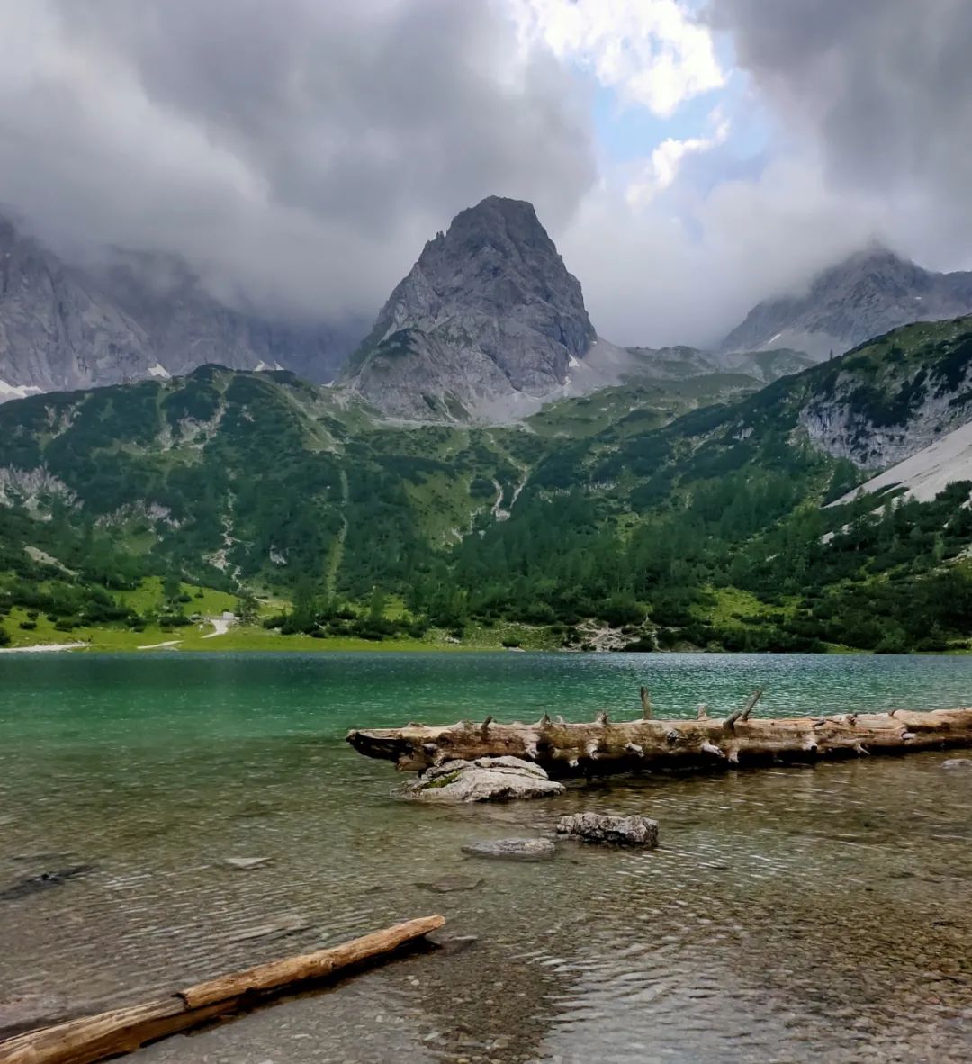
Picture: Seebensee, Austria
July 20, 2021 in Ehrwald, Austria
There are countless mountain lakes scattered in the Alps. The blue-green and quiet lakes, the clear water, and the gray rocks are the pearls hidden in this cold mountain range. Unlike moraine lakes like Lake Geneva, these glacial lakes formed by glacial erosion are not large in area, but are at a higher altitude and are far away from fireworks. They often require a trek to reach them, making them even more isolated from the world.
Lakes Seebensee and Drachensee, located near the Austrian town of Ehrwald, are two of the most famous. Two blue-green alpine lakes, one above the other, look like jasper inlaid in the mountains. They are surrounded by mountains and echo the Zugspitze, the highest peak in Germany, behind them. Since I was going to climb the Zugspitze from here in the next few days, I added hiking to the Twin Lakes in Austria to my itinerary. In the end, it was a worthwhile trip.
route mini-file
Altitude : The starting point of the line (cable car station) is 1505 meters, Lake Sieben is 1657 meters, the highest point of the line (Coburg Chalet) is 1917 meters
Location:Ehrwald, Tyrol, Austria
Route length: 14 kilometers round trip
Hiking time: about 6 hours
Characteristics: Alpine lake formed by glacial erosion in the Eastern Alps
01 Austrian town Ehrwald
Take a flight from Amsterdam to Munich, and then take a more than two-hour train and bus ride from Munich to Ehrwald, a town in Tyrol, Austria, located at the foot of the Zugspitze Peak. Along the way, the scenery outside the car window gradually changed from the city to rolling mountains, verdant forests and rushing rivers. When I got off the train at Ehrwald, it was my first time stepping into the Alps.The small town of Ehrwald is located to the west of the Zugspitze on the German-Austrian border, with an altitude of 994 meters and is surrounded by tall peaks. The climate here is cool in summer, suitable for vacation and summer vacation, and it is a ski resort in winter. The town has a population of more than 2,000 and mainly develops tourism. Walking on the streets of the town, there is no hustle and bustle of the city, and you can see towering peaks all around you.
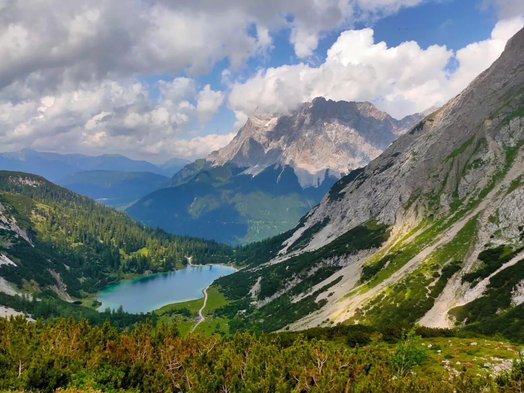
▼ Relative positions of Ehrwald, Siebensee, Loonsee and Zugspitze. Image source: Google Earth
▼ Ehrwald train station platform (10:33 am local time on July 20, 2021)
Germany's highest peak, the Zugspitze, is actually on the border between Germany and Austria. From the Austrian side, there is not much buffer from the foot of the mountain to the top. It almost rises from the ground, like a cliff, lying across the east of the town. In my previous mountain climbing experience, the main peak was often hidden among the mountains more than ten kilometers away. At this time, we faced a height difference of more than 1,800 meters in a short distance. Going up the mountainside, the woods disappeared, and the clearly visible gray limestone mountain was wrapped with huge clouds, towering and insurmountable. This was the first strong feeling. To the majesty of the mountain.
▼The Zugspitze can be seen everywhere on the streets of Ehrwald ( local time 2 July 20, 2021 11:26 )
▼ (20:00, July 20, 2021 local time)
▼ ( local time time 2 July 20, 2021 20:35)
To the south of the town, the Austrian mountains tower. The most eye-catching one is a mountain with a sharp triangular top that reaches into the sky. The town enjoys mountain views everywhere, either at the end of the street, on a certain side of the street, or from the hotel window, you can observe the spectacular mountain from a certain direction.
▼Having breakfast in the hotel, outside the floor-to-ceiling window is the mountain peak to the south of the town ( Local time 2 July 21, 2021 9:07)
▼ ( local time time 2 July 20, 2021 20:39)
▼ ( local time time 2 July 20, 2021 20:33)
02 From the starting point of the hike to Lake SibonIn the morning, we took a cable car from the Ehrwalder Almbahn Cable Car Station (Ehrwalder Almbahn) to the end of the cable car station at an altitude of 1,505 meters. From here, we started the Twin Lakes hiking route. Before reaching Siben Lake, there is a gentle hiking route that is six kilometers long and climbs about 150 meters, which takes about 1.5 to 2 hours. This route winds through the forest, but the hiking path is wide and not difficult. It is also a mountain bike route.The tall and majestic mountain of Zugspitze has always accompanied this route. The route to the left at the intersection in front of the cable car station is to climb the Zugspitze, and the straight route is to Sieben Lake and Long Lake.
▼ You can ride a mountain bike on the section from the cable car station to Xibon Lake . The tall and eye-catching mountains appear all the way ahead.
▼ A waterfall below Sibon Lake, which is very close to Sibon Lake.
After crossing a wooden bridge, not far ahead, a clear view suddenly opened up. A green lake appeared in front of us. This is Xiben Lake. At the same time, we also saw the mountains made of limestone on the other side of the lake. There are often many tourists around Xiben Lake in summer, but if you walk along the lake for a while, it is not difficult to find a quiet place to enjoy the mountain and lake views.▼Panorama of Xiben Lake ( Please view horizontally )
▼Aerial photography of Xiben Lake, the center of the lake is dark blue, and the water near the shore is light green
▼The outlet of Lake Siben is facing the Zugspitze Peak
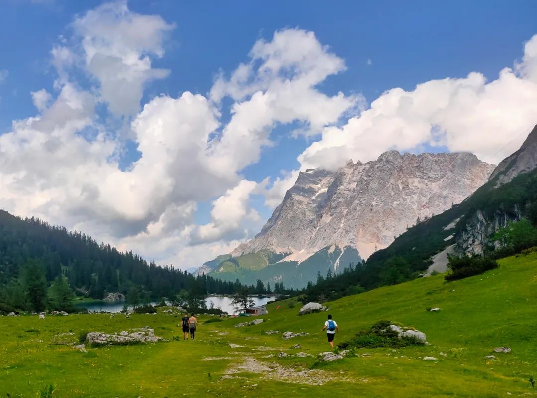
03 From Xiben Lake to Long LakeOn the path beside Lake Sieben, you can already vaguely see the Coburger Hütte (Coburger Hütte) located on the mountainside next to Long Lake. Long Lake is located between the wooden house and the mountain in front of it. If you want to see the scenery of Long Lake, you still need to walk a steep climb of more than 200 meters, which is also the most physically demanding part of this route.▼ Looking at the Coburg wooden house on the edge of Long Lake from the path beside Xiben Lake (the yellow arrow in the upper left part points to the Coburg wooden house)
▼ The alpine pasture passing by Xiben Lake in the direction of Longhu
However, this journey only takes about half an hour. In the European summer, this road is often crowded with tourists. There are families traveling with their children, couples on vacation, and couples carrying their pet dogs on the mountain. Attracting the attention of passers-by.When you turn back and rest during this climb, you will have a perfect perspective overlooking Lake Sibon, like a piece of emerald embedded in the mountains. What is even more eye-catching is the Zugspitze rising behind it. The top of the mountain is puffing with mist, and the dividing line between the woods and rocks on the mountainside is clearly visible.While walking and taking photos, I finally got close to the Coburg cabin. Walking around the wooden house, Longhu suddenly appeared in front of us. The lake is surrounded by steep mountains, like a basin, containing deep and calm water. The lake is not large. On the grass in front of the wooden house, you can overlook the entire lake.The lake's blue-green color contrasts sharply with the surrounding new light green grass, gray rocks, and white snow. If you pay close attention to the color of the lake surface, you will find that there is a curved and lighter strip area in the dark blue, like a dragon crawling on the bottom of the lake. Maybe this is the reason why it is called Dragon Lake.▼Full view of Drachensee. Drachen means dragon in German, and you can see the shape of a dragon on the right side of the lake.Compared with Xiben Lake, Long Lake, which is hidden deeper, has far fewer tourists. I descended from the Coburg cabin to the lake and walked around the lake. I was able to appreciate from more angles how the lake and the surrounding mountains complement each other, how the plump marmots curiously looked at the intruding humans, and how the lazy sheep reacted to each other. This is not surprising.▼ Panoramic view of Long Lake ( Please view horizontally ) After visiting Loon Lake, you can also choose to continue from Loon Lake to the Tajakopf Pass at an altitude of 2,450 meters, and return to the starting point of the Ehrwald Alpine Ranch Cable Car Station through a loop line. Compared to the return route, this loop requires a 340-meter climb and one to two hours of hiking time. Because it was getting late, I chose the route back the way I came. When I arrived at the cable car station, I had missed the last cable car at 5:30 pm, so I had to walk down the mountain back to the town of Ehrwald.▼Returning to Ehrwald from the cable car station in the evening, you can see a waterfall in the mountains in the distanceAll in all, this hiking route connecting two alpine lakes is not very intense, the scenery is beautiful and unique, and it is easy to take photos. The climate is cool in summer, which is a popular season for visiting. There are slightly more tourists and there are obvious signs on the road. After arriving at Loch Loch, you can enjoy food and drinks at Coburg Chalet and even swim in the lake. It is easily accessible by public transportation. For example, starting from Munich, you can take the train to Ehrwald, then take the bus to the Ehrwald Alpine Pasture Cable Car Station, take the cable car to the starting point of the hike, and after completing the hike, return and take the cable car back to the town. .