
Cycling around Qinghai Lake
What remains fresh in my memory is
Lake where water and sky meet
Continuous Qilian Mountains
And the crushing cold rain

Cycling around Qinghai Lake
2018.8.13~2018.8.16
four days
368 kilometers
Altitude range 3084m~3446m
▲
Video 0′51″
The Qinghai-Tibet Plateau is a hot land that countless people yearn for. In addition to rolling snow-capped mountains, vast uninhabited land, rich wild animals and plants, there are also countless gem-like plateau lakes dotted there. The Qinghai-Tibet Plateau Lake District is the largest and highest lake district in my country. The lakes here are deeper, more magnificent and purer than those in the east. Qinghai Lake is the most beautiful and dazzling gem among them, and it is also one of the must-visit destinations in my travel plan.
It’s better to go as early as possible. I just have some time during the summer vacation this year. After changing the itinerary several times for some reasons, I finally decided on the route for the northwest trip two days before leaving. Because it was difficult to buy a direct ticket, I finally arrived in Xining after changing trains several times. However, the continental climate of the plateau after autumn gave me a warning from the beginning.
Without further ado, please read the following travel notes (the guide is at the end of the article).

01 First time entering the plateau, from summer to autumn
DAY 0
Lanzhou—Xining—Xihai Town
After staying in Lanzhou for two days and taking a break, I boarded the train to Xining. These two provincial capital cities are not far apart, with an altitude difference of more than 700 meters. This journey to the west not only gradually goes deeper into the interior in terms of longitude, but also gets closer and closer to the third pole of the earth - the Qinghai-Tibet Plateau in terms of altitude. The former brings later and later sunsets and fewer and fewer people, while the latter makes the air gradually become colder and quieter. The train stopped at Xining Station, which is more than 2,200 meters above sea level. It started to rain lightly, and all passengers were greeted by a late autumn chill. Many people took out their coats and put them on on the platform. After holding on for a while, I had to go to the bathroom and put on my jacket and pants.
Xining is located in the eastern part of Qinghai, in the valley basin of the upper reaches of Huangshui River, and is known as the "Summer Capital". Nearly 40% of Qinghai Province’s population is concentrated in Xining, the provincial capital city. Together with Haidong City in the east of Xining, the two cities together account for nearly two-thirds of Qinghai’s population. The vast land left in the west is sparsely populated and rarely smells like fireworks. This is the gateway to the Qinghai-Tibet Plateau. On the territory of Qinghai Province with an average altitude of more than 3,000 meters, most areas have a cold natural environment. The Huangshui River Valley, with an altitude of only more than 2,200 meters, is one of the few places suitable for survival and reproduction.
▼ The Xining Station, relying on the mountains, is magnificent (picture from the Internet)

I didn’t stay long on the first day in Xining. The bus station is right next to the train station. Today I will take a bus to Xihai Town, the center of Haibei Tibetan Autonomous Prefecture, which is the starting point of tomorrow’s ride. There are a total of 360 kilometers around the lake. I plan to complete it in four days without rushing, which means I have the physical strength and time to get close to the lake. The advantage of cycling is that you can stop and go freely. If you don't stop for a moment, you can just change places and hit the road.
The shuttle bus from Xining to Xihai Town leaves every 20 to 30 minutes, and I got on the bus at around 3 p.m. There were very few tourists on the bus, most of them were locals. Some were wearing Tibetan costumes, and their skin color was darkened by the strong sunlight. I put on my headphones and looked at the scenery when I first entered the plateau. I noticed that there was always a river outside the window. The river was not wide, but it was extremely turbulent. I could even hear the sound of rushing water from time to time. I realized that I couldn't feel the change of terrain in the car. It turned out that from Xining to the Qinghai Lake plain, the altitude rose from 2200 meters to more than 3100 meters - it was all uphill along the way, and the river seemed to be rushing.
Xihai Town, also known as Atomic City, was a former nuclear weapons development base and is now the base camp for cyclists riding around the lake. There are dozens of cycling stations here. As soon as I got off the bus, someone came up to recommend cycling and renting a car, so I went to choose a car with them. In fact, car rental shops are similar. This route does not have many requirements for the car. You just need to try it out and feel it is suitable. In the evening, I took a rental car to stroll around the town. The town was not big, and within a few minutes I drove into the grassland. In the distance were the rolling mountains, surrounded by the Qinghai Lake plain. The sun is setting in the west. As the evening wind blows, the temperature drops sharply. I can no longer feel the temperature brought by the summer sun. I once again realize that I have less clothes, but the temperature should be higher during the day when riding. Some. I stayed in a local family at night. It was extremely clean here. There was no noise of people or cars honking. I just needed to cover myself with a lot of quilts at night. I slept soundly on the first night on the plateau.

02 Qinghai Lake, the unforgettable blue
DAY 1~2
Xihai Town—Jiangxigou—Shi Naihai
After breakfast, we rode out of Xihai Town. The environment was indeed different, empty and deserted. After I set off for a while, a fellow rider caught up with me from behind and asked me to help him adjust the bike. I learned that he came from Jiangsu and had been to Qinghai Lake before. This time he wanted to cycle around Qinghai Lake. I helped him adjust the gearbox, and then we rode together.
▼ The landscape arch on Huanhu East Road is a good place to take photos

The first 50 kilometers are all on Huanhu East Road. The landscape on both sides of the road gradually changes from grassland to sand dunes, with occasional sparse plants on them. The sky is covered with white clouds close to the horizon, filtering out the sunlight and casting alternating light and dark shadows on the undulating sand dunes, making it rich in depth and depth. The sand dunes on both sides of the road are surrounded by barbed wire. In the occasional gaps, a few locals sit at the door to attract tourists. The sand dunes inside provide entertainment projects such as sandboarding and sand motorcycles.
My teammates suggested we go sandboarding together. We parked the car at the gate of the fence, chose a high sand dune inside, and dragged our sandboarding mats up to the top. Looking down from the top of the dune, the large slope is high and steep. To be honest, I am scared. But after skating once, I found that it was safe, so I let go and tried to slide faster and faster. Although sandboarding is fun, climbing to the top of the dune consumes a lot of energy every time.
▼ Sand dune landscape by Qinghai Lake


The straight road turned a corner, and I suddenly found a blue belt in the distance stretching between the sky and the earth. Above the belt were golden sand dunes, and the tops of the sand dunes were covered with white clouds. Riding closer and closer, I finally confirmed, wow, that is Qinghai Lake! After that, followed the winding road, and the lake we saw was sometimes far away and sometimes close. It was there, but it was inaccessible.
More than 50 kilometers into the ride, there is a lake in the east of the Erhai Lake, which is actually a lake separated from Qinghai Lake. The water here is shallow and grassy, and the lake reflects white clouds. A dike separates it from Qinghai Lake. These They are all wetlands surrounding Qinghai Lake, nourishing the pasture cattle and horses by the lake.
▼ Erhai Lake in the east of the lake forms the wetland beside Qinghai Lake

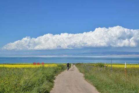
Pass a three-way intersection and enter National Highway 109. At this time, I found that I was getting closer to the lake, and the landscape around the lake turned into continuous rapeseed flowers. It's mid-August now, and the season when rapeseed flowers bloom in large areas has passed. What you can still see is the delayed planting by local people, mainly for the convenience of tourists to take pictures. In this way, no matter when you come, you will still be able to see the scene of rapeseed flowers all over the Qinghai Lake. This section of the road is busy with traffic and tourists. To enter each section of the trail leading to the lake, you need to pay local people a "ticket" of 5 to 10 yuan.
▼ From the foot of the mountain to the plain near the lake, this continuous stretch of rapeseed flowers is planted.


We chose an entrance and rode in. It looked like the lake was not far ahead in this section, but in fact there was still 2 kilometers to ride to the lake - this was the first close contact with the lake.
▼ Father and son by the lake

We arrived at Jiangxigou, our accommodation place, at around 6 pm that day. From the map, we would have to take a route closer to the lake tomorrow, which is the main body of the lake. Although we were a little tired on the first day, we were looking forward to the next day’s trip.
I woke up once in the early morning (probably from the cold), opened the door, and took a look at the sky. Wow, the sky was filled with stars. A Milky Way ran through the night sky. I was almost amazed. This place is closer to the horizon and far away from light pollution. I haven’t seen such a pure night sky for many years.
The route on the second day was relatively straight. On the left was the rolling Qilian Mountains, which were relatively small in height and covered with lush green grasslands. At this altitude, only grass can grow. The mountains are like a city wall, surrounding a plain of Qinghai Lake, where herders living around the lake live. I want to climb to the top of this mountain range and see what kind of landscape is outside the "city wall". Do the people living here also have this idea? On the right side of the highway, the vast Qinghai Lake stretches into a blue silk fabric, spreading where the sky and the sea meet. It is impossible to see where the silk fabric begins and ends. What we passed today was the broadest belly of the lake. If we suddenly came here without any information, would we think that this was the sea?
▼ Lakeside pasture, flocks of cattle and sheep

We arrived at Heima River at around 1:00 p.m. This is the only way to Chaka Salt Lake. This time I did not plan to go to Chaka Salt Lake. Considering that there are many tourists here, it has exceeded the capacity of the scenic spot, and the salt lake is not large in size. I think such a place must have fewer people to reflect its unique beauty. Going there at this time may not meet your expectations. After a late lunch here we continued our ride.
▼ Coming out of Heima River, there is a cement road leading to the lake. The lake here is blue and deep.


▼ From the Black Horse River to Shi Naihai, the lake here is close to the shore, showing a light blue color. It is not as broad and surging as the previous ones, but lies quietly in this bay of the lake, embracing the Bird Island on the other side.


Crossing a mountain pass, five-color prayer flags covered the top. After climbing up the slope, there is a section of downhill ahead. The township not far away is Ishinai Township, where we will stay tonight. Today’s journey was less than 90 kilometers, and we arrived at our accommodation after 6 pm, but we saw the most beautiful lake view that day.
▼ A mysterious mountain pass on the roadside, I don’t know where it leads

▼ Five-colored prayer flags welcome passers-by

▼ Go out and take a look the next night. Under the moonlight, you can see large dark clouds in the distance, which indicates that there will be rain.


03 The house leaked and it rained all night, causing my teammates to puncture three tires in a row.
DAY 3~4
Shi Naihai—Hargai—Xihai Town
On the third day of riding, when we came out of Shi Naihai, the sky was overcast, covering the mountains and towns in front of us, and there were quiet grasslands on both sides of the road. During the past few days of riding, I occasionally found pikas on the roadside, a small animal that looks like a rabbit and a mouse. This is an animal that can be seen up close while riding in Qinghai Lake.
▼ Grassland, sky, dark clouds, mountains - there are few people on the road

▼ I was waiting for a train to pass by the lake

It is about 13 kilometers from Shi Naihai to Bird Island. The Bird Island Scenic Area was closed in April this year due to the need for nature protection, so we continued riding forward. The road around the lake from Bird Island to Quanji Township is the last section where you can see the lake. The water in the lake is not as clear as before, but the waves are rougher. This place is located on the west bank of the lake. The waves formed by the east wind blowing on the vast lake surface hit the beach one after another, showing another kind of momentum of the big lake.
▼ The clouds are getting thicker and thicker, and the wind blows the prayer flags rattling

Today we have ridden 80 kilometers to Gangcha County. It is still three o'clock in the afternoon. We decided to continue riding 28 kilometers to Hargai Township, so that the last day's itinerary will be greatly reduced. There is a mountain pass coming out of Gangcha County, and you can see the spectacular fish murals and prayer flags welcoming passers-by at a glance.
▼ Gangcha County, located on the north shore of Qinghai Lake, is rich in catfish.

▼ The wind blows the iron blades and drives the prayer tube below to slowly rotate, turning the prayers for passers-by.

The 28 kilometers we just checked to Hargai had a lot of uphill climbs, and with the headwind, it took us nearly three hours. Since most tourists will not stop in Hargai Township during their itineraries, it is much more deserted than the previous towns, so accommodation here is also much cheaper. We stayed in a hotel run by Tibetans on the street, and the accommodation was much better than the previous two days. The local people I have come into contact with these days are all Tibetans. They have lived here for generations and rarely leave their hometown. Most of them are very simple, and some of them are not very fluent in Chinese. It is because of the tourism industry that they have come into contact with people from all over the world.
After my companions settled in, they went outside for a walk. I looked at the sky in the west. A dark cloud hung down like a curtain. At the same time, there was a lot of wind blowing, bringing a lot of chill. Autumn begins quickly in Qinghai, and there is not much residual warmth from summer at this time. I remembered that the Tibetan girl at the front desk of the hotel said that the wind was very strong today, and I was worried that it might rain tomorrow, but there was only one-sixth of the distance left, so there shouldn't be any big trouble.
Sure enough, when I woke up in the morning, it was raining outside, and there was almost no one on the road. I told my partner that it was a good thing we rode to Hargai yesterday, otherwise we would have had to ride 90 kilometers in the rain today. Moreover, I took advantage of the good weather to see enough of the lakeside scenery in the first two days, otherwise I would have left a lot of regrets.
▼ We put on our raincoats and set off from Hargai Town. The streets here are deserted, with uniform two- and three-story buildings on both sides. Looking from the top of the building, you can see grasslands on all sides in the distance.

Before we had ridden five kilometers, we encountered the most unfortunate thing these days - my teammate's car had a puncture, both the front and rear wheels. Faced with the pouring rain, we had to find a place to take shelter and start repairing the tire. It took a lot of trouble. First, one of the tires was still leaking after it was repaired. The reason was that the water in the tire repair area was not cleaned up and the tire rubber was not firmly adhered. What was even more unfortunate was that we finally repaired the tire and installed it. After continuing to ride, another tire was punctured. This should be because wire or glass shards had been inserted into the tire and had not been cleaned out. We finally gave up this time. We were still more than 50 kilometers away from Xihai Town. My partner said it would be better to hitchhike back on the road, so I continued riding.
Wearing a raincoat when riding, the wind resistance increased a lot, making it almost difficult to walk uphill. The first ten kilometers were very slow, and it was already too late to arrive at 2pm. The slanting wind and heavy rain had already made my shoes and some of my clothes wet. After a while, I had to clean up the small puddles on my raincoat. The rain brought the temperature down, and I was shivering a little from the cold. I just wanted to ride to the finish line as soon as possible. This was the most difficult section of the ride. Finally, taking advantage of the downhill slope, I rode the last thirty kilometers in one go. When I returned to the landlord's house where I lived before, the landlord saw that I was in a mess and poured me some hot water to drink. I used their house to change my clothes and then I felt that my body was slowly recovering. I packed up my things, returned the car, and returned to Xining from Xihai Town with my teammates. This journey of beautiful scenery and exhaustion finally ended.

Qinghai Lake Cycling Guide

The cycling route around Qinghai Lake is about 360 kilometers in total, including Huanhu East Road, 109 National Highway, Huanhu West Road and 315 National Highway. Most of the route is straight, with occasional climbs, and the overall climb is not large. Most people will choose Xihai Town in Haibei Prefecture as the starting point for circling the lake, and ride clockwise to get closer to the lake. There are few forks in the whole journey, so it is almost impossible to get lost. Just make sure the lake is on your right. Of course, you can also search for the road book navigation around Qinghai Lake on the Traveler APP.


After arriving at Xining Station, walk to the bus station next to Xining Station. Take the shuttle bus from Xining to Xihai Town, which runs approximately every 20 to 30 minutes. The total journey is 110 kilometers, the fare is 25 yuan, and it takes more than two hours. Note that the latest bus is at 5:30 pm. After circling the lake, return to Xining and buy a ticket at Xihai Town Bus Station.

If you are just going around Qinghai Lake, you don’t need to bring your own car. There are many car rental shops in Xihai Town, each of which provides mountain bikes and road bikes of different grades. The price for a trip around the lake is around 150 to 400. The rental car is equipped with helmets, camel bags, raincoats, vehicle repair tools, etc.

The basic equipment for cycling will be provided at the car rental station, so consider bringing a pair of cycling pants. In addition, be sure to protect yourself from the sun. You can choose magic headscarves, cycling gloves, sun protection sleeves, fisherman hats, etc. Do not expose your skin to direct sunlight. The temperature difference on the plateau is large and it is very cold in the morning and evening. It gets even colder when it rains. Be sure to bring a jacket and trousers to prevent catching a cold.

There are accommodation spots in the towns and villages passed along the way, including Xihai Town, 151 Base, Jiangxigou, Heimahe, Shinaihai, Bird Island, Quanji Township, Gangcha County, Hargai Township, etc. During the peak tourist season of July and August, accommodation in Heimahe is more expensive, while accommodation in Xihai Town, Quanji Township, and Hargai Township is cheaper.

Most people choose a four-day trip to complete the lake tour, which allows them to have more time to see the lake up close. There are many accommodation spots on the road, and you can choose your daily itinerary flexibly. Below is my actual itinerary around the lake. (This itinerary did not go to scenic spots such as Chaka Salt Lake and Bird Island.)
DAY 1: Xihai Town-Jiangxigou, 100 kilometers;
DAY 2: Jiangxi Valley-Shi Naihai, 88 kilometers;
DAY 3: Shi Naihai - Hargai, 110 kilometers;
DAY 4: Hargai-Xihai Town, 62 kilometers.
The advantages of this arrangement are that firstly, the daily itinerary for the first two days will not be too long, and there is enough time to ride to the lake to enjoy the lake view. The most beautiful sections of the road are in these two days; secondly, the accommodation avoids the many tourists. The expensive Heima River. If you don’t go to the Heima River specifically to watch the sunrise, it is recommended to ride to the next accommodation. Third, try to ride as much distance as possible on the third day. Since there are not many places to stop and enjoy the scenery on this day, arriving After checking the county, you can continue riding to Hargai Township, where accommodation is cheaper, and you have plenty of time left on the last day, so you can rush to Xihai Town as soon as possible.

The 20 to 40 kilometers of riding in Xihai Town is a sand dune landscape, where you can choose from entertainment projects such as sandboarding and sand motorcycles.
From the Sancha intersection to Jiangxigou, you can see rape flowers planted by the lake along the way.
Jiangxigou to Shinaihai is the most beautiful section of the route around the lake. In most places, you can see the lake while riding. There are passages in many places where you can ride to the lake and slowly enjoy the scenery.
The section from Gangcha County to Xihai Town is surrounded by quiet grasslands, with rolling mountains visible in the distance. There is no lake in sight on this section.

Since the Bird Island Scenic Area has been closed since April 2018, tourists are unable to visit Bird Island.
If you want to go to Chaka Salt Lake, you need to charter a car at Heimahe. The whole journey takes about 5 hours.
Most of the roads around the lake are not wide, so be sure to ride to the side. Pay special attention to the gusts of wind caused by large trucks and buses whizzing by that may knock down cyclists.
In short, no matter what, you must pay attention to safety when traveling, and you can bring good memories every time you come back.