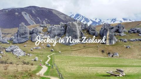
castle hills castle hills
You will spend a lot of time on the road this day, so you will get up early in the morning and set off.
Along the way, there are flat grasslands on both sides, and you can see a few cattle and sheep from time to time. The snow-capped mountains in the distance begin to appear, the white snow gradually melts from the mountainside, and the feeling of spring spreads to the horizon. There are cheerful songs playing in the car, but my heart is peaceful and comfortable.
Starting from Christchurch and heading west, it takes almost an hour to drive there. Park the car at the entrance. Apart from the snow-capped mountains in the distance and the Castle Hills road sign at the intersection, you can only see a winding path leading to piles of rocks in the distance. Just when I was wondering if it was this place, I saw another tourist or resident walking into the trail carrying a backpack and wearing sportswear.
So he followed him.


After walking for more than 1 kilometer, I saw this giant rock formation, which is famous as one of the filming locations of "The Legend of Namibia" and "The Lord of the Rings". From a distance, they look like piles of rubble, but when you get closer, you realize that these piles are stacked on top of natural rocks, and they turn out to be several stories high. Moreover, although the stones have various shapes, they are indistinguishable at a glance. Turning around here will make you dizzy, like walking into a maze.
Because of the movement of the earth's crust, these stone groups rose from the sea floor to the land. It is not only a historical witness of the earth's evolutionary changes, but also a training ground for rock climbers and a visit place for hiking enthusiasts. The small pits on the rock surface are said to have been carved out by climbers.


Arthurs’ Pass National Park Arthurs’ Pass National Park
Continuing more than 60 kilometers west is Arthurs’ Pass National Park. When the car arrived here, it was already in the heart of the Southern Alps, the highest point in New Zealand. The terrain here is complex, diverse and very distinctive. The east side is the river bed, while the west side is the mountain forest. Many areas are affected by ancient glaciers, forming some steep slopes and some flat-bottomed valleys.
As soon as I got off the car, I felt the low temperature at high altitude and it was raining lightly.
The shawl can no longer keep out the cold, so replacing it with light down, along with a raincoat necessary for travel, greatly reduces the inconvenience of walking in the mountains and forests. The sign at the entrance clearly states the length of the trail and the time required. Considering the physical strength, time, and bad weather, I decided to walk to Devils Punchbowl Falls and return. Although I really want to walk the entire distance and see all the scenery, today is really not a suitable day for a long hike. I had to mark it quietly in my mind.


Devils Punchbowl Falls
This is just one of the points in Arthurs’ Pass National Park.
I believe that if you have the opportunity to continue walking in the park, you will really have the opportunity to discover more. I like hiking, so when I travel, I often choose scenic spots such as national forest parks or outdoor natural areas.
After passing the sign for Historic Walk, I began to hear the sound of water shaking the valley. What follows is an uphill mountain road, and the pace slows down and becomes increasingly difficult. The road is slippery on a rainy day and is not easy to walk on. It took more than half an hour to walk 1 kilometer to reach this 131-foot-tall waterfall.
The country has rich landscapes, including many magnificent waterfalls. I have also visited several waterfall landscapes abroad, and the Devil's Blackjack is really not particularly outstanding. The observation deck at the bottom is very narrow, so you can’t find a good location, the lens is not wide-angle, and the weather is not good. No matter how I shoot it, I feel unsatisfied.
Finally, I chose a lower place, using the high position as a shield, and only took pictures of the downstream end of the waterfall.


If you are not careful along the stone steps, you will miss this little wooden horse.
There is a little story written here.
The girl named Kiere passed away at a young age because her life was short. Every time her family went to a place she wanted to visit but had no chance to go again, they would leave a wooden horse as a memory of her.
Turning over the back, there is a girl with a bright smile. Really the most beautiful angel.
It feels like the Trojans and photos have been here for a long time.
But no one passing by destroyed them.
I think her family really loved her. Miss her very much.


Lake Brunner
This point was not included in the original planned itinerary.
I just continued walking along Route 73. When I saw the sign saying that a few kilometers ahead was Lake Brunner, I thought it wasn't far anyway, so I came over. Unexpectedly, we drove into a mountain forest, and it was an undeveloped gravel road. After driving for a long distance, the road conditions did not change.
I feel a little regretful that I have caused trouble for myself. But this is a one-way street. If you turn around and drive back directly, not only will it take time, but it will also be very dangerous if two cars meet. I had no choice but to bite the bullet and continue moving forward, and ended up taking a circuitous route to the lake.
The surrounding area is really quiet and deserted.
You can't hear the wind blowing the leaves, nor the waves of the clear water, but occasionally there are a few birds chirping. It's so daytime, so quiet. Looking at the lake surface again, it is as smooth as a mirror.


New Zealand is a country of thousands of lakes, and there are also various lakes in my next trip.
Although it is deep in the mountains, I quickly checked this lake while there was a signal, but there is not as much information as other lakes. It seems that few people really know about it. Moreover, the pictures uploaded by others are different from the scenery I saw.
I guess I ended up on the other side of the lake by accident.
No wonder it looks primitive, quiet and deserted. At this moment, I felt like I had discovered a new world. As David Dallas sang in "RUNNIN'": I got a new world in my view.
Continue on the road where you can see the snow-capped mountains, heading west towards Greymouth.

Punakaki Pancake RocksPunakaki Pancake Rocks
This is an important goal in my day's itinerary. It is so important that I deliberately go north first, then backtrack and continue walking south. Because when the tide is high here, there will be unique and spectacular scenery, and I really want to verify it with my own eyes.
When we arrived here, we didn't even see the raging tide, but we were already surprised by the layers of rocks that looked like thousand-layer pancakes. While waiting for the tide to rise, I scrolled through my mobile phone to find out the origin of this strange stone: for 30 million years, after the death of small creatures on the seabed, they were alternately laminated with sand and soil, thus forming a multi-layered area. Due to the movement of the earth's crust, the seafloor level rises and exposes these rocks to the surface. After being eroded by rain and wind, these layers stand vertically along the cliffs and ravines, like layers of pancakes.
Looking at it now, the cliff is abrupt and rugged, with hundreds of stone pillars standing in it. It took thousands of years of carving to achieve this ingenious creation.


There are two famous high tide landscapes here: First, in many places deep in the cliffs, vertical wind wells are formed due to the humidity of rain and the beating of sea water. At every spring tide, seawater rushes into the narrow channel and rushes out through a large number of vertical blowholes, forming fountain-like water columns from time to time.
The second one is Blowhole, is a huge rock hole that connects to the sea below. When the tide comes, the sea water will pour in here, and the water spray column formed by the squeeze can reach tens of meters high, and the sound is as loud as the roar of a monster.


It's a pity that I failed to do a good job on this trip.
Before setting off, I checked the information and accidentally saw a blogger mentioning that the high tide scene is in the evening, so I always thought it was between 5 and 7 pm. Waited here for almost 3 hours. I was bored all the time and read "What do you see?" over and over again. I found the animals one after another and walked around the one-way trail.
I wanted to leave several times, but I was afraid of missing it.
Fortunately, spring has begun and it gets dark later, almost 8pm. Because we still have to go 80 to 90 kilometers north to stay in the town of hokitika. In the end, we really couldn’t wait any longer. With regret, we took a selfie with the entrance and the door sign as a souvenir.
They say you should leave some regrets when traveling, so that you will never forget them.
Let me believe it for now.

