There are four major routes into Tibet: Sichuan-Tibet Line, Yunnan-Tibet Line, New-Tibet Line, and Qinghai-Tibet Line. Today we will learn more about the Qinghai-Tibet Line and see the "Suez Canal" on the roof of the world. Those magical names: Kunlun Mountains, Hoh Xil, Wudaoliang, Tuotuo River, Tanggula Mountain, etc. are on this line.
about
Qinghai-Tibet Highway: the lifeline of Tibet
The Qinghai-Tibet Highway refers to the 109 National Highway from Xining City to Lhasa City, with a total length of 1,937 kilometers. Construction of this highway started in 1950 and was opened to traffic in 1954. It was later converted to a secondary highway standard in 1974. The roadbed is 10 meters wide, the gradient is less than 7%, and the maximum driving speed is 60 kilometers/hour. The Qinghai-Tibet Highway is an asphalt pavement laid in an alpine and permafrost area without precedent in the world. It is the largest project in the history of Chinese highways. The average altitude of the Qinghai-Tibet Highway is more than 4,000 meters. Although the altitude is very high, it is located in an ancient lake basin landscape, so the overall undulations are gentle.

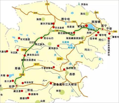
Qinghai-Tibet Line Route Map
The Qinghai-Tibet Highway is an important channel connecting Tibet with the mainland. In the highway era, it was responsible for transporting more than 85% of materials entering Tibet and more than 90% of materials leaving Tibet. It is known as the "lifeline" of Tibet.
Attractions
Summary of scenic spots along the Qinghai-Tibet Line
The specific itinerary of the Qinghai-Tibet line: Xining - Daotang River - Chaka - Golmud - Wudaoliang - Tuotuo Riverside - Yanshiping - Tanggula Pass - Amdo - Naqu - Damxung - Yangbajing - Lhasa.
The route from Xining City to Golmud City: Climbs over high mountains such as Rubber Mountain (3,800 meters above sea level), Wanggaxiu Mountain (3,680 meters above sea level), and Tuotu Mountain (3,500 meters above sea level), and crosses Dashui River, Xiangride River, and Gaikeguang River. , Brazil River, Qingshui River, Hongshui River and other rivers, with a total length of 782 kilometers, of which 564 kilometers belong to plain and slightly hilly areas, and 218 kilometers belong to heavy hilly areas. The entire altitude is 2200-3800 meters.
The route from Golmud City to Lhasa: Climb the Kunlun Mountain Pass (4,600 meters above sea level), Fenghuoshan Mountain (5,010 meters above sea level), Tanggula Pass (5,320 meters above sea level), Touerjiu Mountain (5,180 meters above sea level) and other high mountains, and cross the Chumar Mountains River, Hongliang River, Qushui River, Xiushui River, Beilu River, Yamal River, Tongtian River and other rivers have a total length of 1161 kilometers, of which 1013 kilometers belong to Pingqiu District and 148 kilometers in Chongqiu District. The entire section is above 4,000 meters above sea level.
The Qinghai-Tibet line is basically desert, Gobi and grassland. The scenery is relatively simple, but many scenic spots are still very beautiful and shocking.
——————————————————–
Since we will also write about Xining and other Qinghai guides in detail later, here we will briefly mention the scenic spots on the Qinghai section of the Qinghai-Tibet line.
1. Kumbum Temple
Kumbum Monastery is one of the six major monasteries of the Gelug Sect (Yellow Sect) of Tibetan Buddhism in China. It is the birthplace of Tsongkhapa, the second largest Buddha in the world. It was built in 560 AD. Kumbum Temple has a pagoda first and then a temple, so it is named Kumbum Temple. Here you can fully appreciate the far-reaching cultural charm of Tibetan Buddhism.
Transportation: There is a special bus line 23 in Xining City that goes directly to Kumbum Monastery for 3 yuan/person. You can also share a taxi with several people, 4 people, 15 yuan per person.
Tickets: 80 yuan/person, free for active servicemen, disabled soldiers, retired military cadres, and children under 1.2m; half price for students, senior citizens, and disabled people; more famous museums, such as Butter Flower House, Sutra Printing House, and Murals , Thangka, etc. are entered with a ticket, and other small restaurants are free to enter.
2. Jinyintan Grassland
About two hours' drive from Xining, you will reach the very famous grassland in Qinghai - Jinyintan Grassland.
Wang Luobin, the king of western singers, wrote the famous song "In That Distant Place", which describes this place. He met a beautiful Tibetan girl Dolma here and wrote this song, which made Jinyintan Grassland even more famous all over the world.
3. Riyue Mountain
It leaves Xining and passes 40 kilometers southwest of Huangyuan County to Riyue Mountain, with an altitude of 3250 meters and belongs to the Qilian Mountains. The Shandong slope is green and green because it is the windward slope of the summer wind, while the Shanxi side is slightly browned due to the leeward wind, with clear yin and yang.
Riyue Mountain has always been the choke point from the mainland to Tibet. Historically, it was the dividing line between the Tang Dynasty and Tubo. Emperor Taizong of the Tang Dynasty asked Princess Wencheng to marry far away from Tibet to calm the war, and gave her a precious mirror to accompany her. A stone tablet marking the boundary between Tang and Tibet was erected at Riyue Mountain Pass.
Transportation: Generally long-distance buses only drive from Xining to Huangyuan County. After arriving at Huangyuan, charter a bus to this point, which is about 20km and costs about 80 yuan for a round trip. You can also take a one-day tour of Qinghai Lake from Xining Travel Agency, which costs about 150 yuan per person. If you have your own transportation, you can go by yourself.
Ticket: 30 yuan/person
4. Daotang River
Continuing on for about 40 kilometers from Riyue Mountain, you will arrive at Daotanghe Town. Daotanghe is a seasonal river originating from Riyue Mountain and relying on snowmelt and rainwater. Since ancient times, there has been a saying that "a river of spring water flows eastward" According to the Dharma, the Daotang River is a river in which "all rivers flow east, but I flow west."
Transportation: Drive by yourself, take a shuttle bus, or charter a car/ride
Tickets: 15 yuan/person
5. Qinghai Lake

Qinghai Lake
It is also known as "Kukunaoer" and "Cuowenbu", which means "blue sea" in Mongolian. Located in the Qinghai Lake Basin in the northeastern part of Qinghai Province, it is the largest inland lake and the largest saltwater lake in China.
July and August are the best times to go to Qinghai Lake. Rapeseed flowers are in full bloom, and the annual cycling race around the lake is also held during this time. The blue sky, white clouds, lake light, mountain scenery, and grassland complement each other, which is very beautiful.
Transportation: Take the shuttle bus, charter a car, or drive there.
Tickets: There are no tickets for Qinghai Lake itself, but there are tickets for some attractions. It costs 45 yuan to take a cruise. You cannot take a cruise in winter. Tickets for the beach are 22 yuan; tickets for Bird Island are about 100 yuan. Shadao costs about 100 yuan.
6. Chaka Salt Lake

Chaka Salt Lake
Chaka Salt Lake is also called "Chaka" or "Dabuxunnur", which means "shore of the salt sea" in Tibetan. It is a natural crystalline salt lake in the Qaidam Basin. Its salt production can be used by the people of the country for about 75 years.
The small train leading to the center of the lake is a popular vehicle for tourists. The sign on it reads "JM80Q Diesel Locomotive of the People's Republic of China, Made in Jiangsu", which has a sense of historical vicissitudes.
Chaka is currently facing the dilemma of environmental pollution. Those who want to go must protect the environment!
Transportation: 1. Xining Long-distance Bus Station has a shuttle bus to Ulan County. It passes through Chaka Town. There are five buses a day. The fare is about 80 yuan. The chartered bus costs about 400 yuan for a round trip on the same day. 2. Charter a car from Heimahe and it costs about 200 yuan.
Tickets: 60 yuan/person, group ticket 50 yuan/person, small train ride 35 yuan/person
7. Dulan

The tree-lined road in Dulan County
Dulan (meaning "warm" in Mongolian) is located in the central part of Qinghai Province and the southeastern part of the Qaidam Basin. The total area is 50,000 square kilometers. Mainly the Han nationality, there are also Tibetan, Mongolian, Hui, Tu and other ethnic minorities. It is close to the grassland of Inner Mongolia. The most beautiful grassland in Qinghai, Dulan Grassland every August, thousands of flowers bloom, layer upon layer, and the fragrance of flowers is fragrant.
8. Koruk Lake and Tuosu Lake
Known as the "Alien Site", the two lakes are seven kilometers apart and connected by waterways, one salty and one fresh. According to local legend, the two lakes are also called Lover's Lake.
9. Qaidam Basin

Qaidam Basin
There are colorful Danxia landforms in the Qilian Mountains in the Qaidam Basin, and there are also purple Danxia, which is the color missing from the colorful Danxia in Zhangye.
The Qaidam Basin is a plateau basin and one of the three major inland basins in China. There are more than 5,000 saltwater lakes in the basin. Qaidam is a world of salt.
10. Golmud
Golmud is located in the hinterland of the Qinghai-Tibet Plateau. It is the third largest city on the Qinghai-Tibet Plateau and a transit point for supplies entering Tibet. It has a population of 300,000. Nearly 90% of the city's land belongs to the desert or semi-desert Gobi Desert. Golmud's Chaerhan Salt Lake, Kunlun Pass, and Golmud Populus euphratica forest are all spectacular and beautiful.
Different from the Gobi in remote areas, the urban area of Golmud is like an oasis. The city is lined with green trees and flowers, and the suburban farmland is green and lined with trees.
11. Kunlun Pass

Kunlun Pass
When you reach the Kunlun Pass, you can see the towering Kunlun Mountains, which is really majestic. The only way to enter Tibet is also the beginning of the challenge of altitude sickness, with an altitude of 4772 meters. Further ahead is Hoh Xil.
Paul Theroux, a modern American train traveler, once wrote in the book "Traveling in China": "With the Kunlun Mountains, the railway will never reach Lhasa." Unfortunately, Paul was wrong.
12. Hoh Xil

Hoh Xil
Hoh Xil is the largest uninhabited land in China and is known as the "Third Pole of the World". It is a paradise for Tibetan antelopes, wild donkeys, wild yaks, gazelles and other wild animals. Therefore, it is easy to see Tibetan antelopes, wild donkeys and other wild animals in this section.
Suonandajie Nature Protection Station is located in Hoh Xil. It is the first private natural ecological environment protection station in China. Hoh Xil is the largest uninhabited land in China and is known as the "Third Pole of the World".

Tibetan bison in Hoh Xil
There is an exhibition hall for Tibetan antelopes in the protection station, as well as an exhibition of Sonam Dajie’s deeds. It also provides some food and accommodation guarantees for passing tourists, solves some difficulties encountered by travelers, and provides some protection within its capabilities.
13. Ice-free spring
It is said that the spring water here gushes out all year round and never freezes even in the cold winter, so it is called the "freezing spring". The ice-free spring is regarded as a sacred spring by local Tibetans. The Lage section of the Qinghai-Tibet Railway has the most difficult control project, the Bufrost Spring Bridge, with a total length of 2.95 kilometers.
14. Wudaoliang

Passing through a mountain pass in Wudaoliang Village
Wudaoliang is located in the middle section of the Qinghai-Tibet Highway, known as the "Road to Heaven", at 3007 kilometers of National Highway 109. It is named after the five mountain ridges nearby. The climate here is high and cold, with long winters and no summers. It is famous for its high altitude, lack of oxygen, and harsh and changeable climate. Therefore, Wudaoliang is generally considered to be the threshold to enter the plateau and is considered to be the most difficult section on the Qinghai-Tibet line. If there is no problem in Wudaoliang, then there should be no problem in crossing Tanggula Pass and entering Tibet.
15. Tuotuo River
Also known as Tuotuo River and Wulan Mulun River, it means "Red River" in Mongolian. It is located in the southwest of Qinghai Province, China and is the main source of the Yangtze River. It originates from the Jianggendi Ru Snow Mountain glacier on the southwest side of Gradandong, the main peak of the Tanggula Mountains. The end of the glacier is nearly 5,500 meters above sea level.
The highest peak in the Tanggula Mountains is Geladandong Peak, with an altitude of 6,621 meters. Jianggu Diru Glacier, the largest valley glacier in the southwest of Geladandong Peak, has a course of 12.8 kilometers and an altitude of 5395 meters at the end. It is the birthplace of the Yangtze River.
16. Tanggula Pass

Tanggula Pass
Tanggula Mountain is a famous mountain in Tibetan areas. It is also called Tangla Mountain or Tangla Mountain. It means "mountain on the plateau" in Tibetan and is also a famous mountain god in Tibetan areas.
On the Tanggula Pass, the view is much wider than on the Kunlun Pass. There are crystal clear snow-capped mountains standing in the distance, and the sun is stronger than that on the other side of the mountains. The real plateau has arrived!

Tanggula Pass Monument
Tanggula is the dividing line between Qinghai and Tibet, with an altitude of 5,231 meters. There are monuments and landmarks built at the mountain pass. It is the only place to enter Tibet along the Qinghai-Tibet Highway and is the birthplace of the Yangtze River.
17. Anduo County

Anduo Grassland
Anduo County has a vast territory, complex terrain, and extremely rich natural resources. It is considered to be the largest virgin land of natural resources in the country. There are vast grasslands, among which Amdo Grassland is one of the four largest grasslands in northern Tibet. Amdo County is also a natural wildlife kingdom, with wild yaks, Tibetan wild ass, Tibetan antelope, blue sheep, argali, yellow sheep and other wild animals.
There is a lake in Amdo County called Cuona Lake. The green water in the lake is clear and the fish are jumping. Looking from the lake, Zhuoge Shenfeng is looming, and the mountains and rivers complement each other. It is a "holy lake" in the eyes of the local Tibetan people. In the Tibetan Year of the Dragon, thousands of believers will come to worship.
To the east of the lake, the Qinghai-Tibet Railway passes close to the quiet and beautiful Shenhu Lake, with the nearest point only 20 meters away.
18. Nagqu City

Nagqu grassland
Nagqu is located in the north of Tibet, between the Tanggula Mountains and the Nyenchen Tanggula Mountains, with high altitude, lack of oxygen, and dry climate.
There are rolling clouds, sparkling water waves, rolling mountains and endless vast grasslands. May to September is relatively warm, which is the golden season of the grasslands. During this period, the climate is mild, the wind is beautiful, the grasslands are green, and everything is lush. People are happy and animals are prosperous, especially the grand Nagqu Horse Racing Meeting held in August, which adds to the melodiousness and pride.
Nagqu is an important town in northern Tibet. It means "Black River" in Tibetan. It is 4,800 meters above sea level. It is a distribution center for livestock products. Xiaodeng Temple, a famous temple in northern Tibet, is located in the town. It connects to Qamdo in the east, Ngari in the west, Xining in the north, and Lhasa in the south. It is the administrative, economic and transportation center of northern Tibet.
19. Damxion County

The three forts of a northwest restaurant in Dangxiong
Damxung County is located in the north of Lhasa. It is the core area of the Qinghai-Tibet Plateau. It has beautiful scenery and well-developed tourism industry. The most famous scenic spot is Namtso, one of the three holy lakes in Tibet.
20. Namtso

Namtso Holy Elephant Gate
Namtso is located between Damxung County and Nagqu Bangor County in Lhasa, about 200 kilometers northwest of Lhasa. It is the second largest saltwater lake in China and the highest large lake in the world. The lake is as vast as the sea, the traces of Mani piles, the swaying colorful prayer flags, and the holy beauty of Namtso are irresistible.
"Namtso" means celestial lake, spiritual lake or sacred lake. The five islands in the lake stand out among the vast expanse of blue waves. Buddhists say that they are the incarnations of the five Buddhas. Anyone who goes to the sacred lake to pay homage to the Buddha will do so devoutly. Worship.
21. Yangbajing
Yangbajing is located at the intersection of the Qinghai-Tibet Highway and the China-Nepal Highway and has geothermal hot springs.
22. Lhasa

Lhasa Potala Palace
After crossing the desolation of no man's land and experiencing the vicissitudes of nature, we finally arrived at our spiritual home - Lhasa.
Self drive
Self-driving travel: Self-driving Qinghai-Tibet line guide
This is an itinerary I arranged that is not too rushed. This is suitable for students who have plenty of time to drive by themselves.
D1, Lhasa - Namtso - Damxung [New regulations have been implemented in the Namtso Scenic Area in 2019. Except for scenic cars, other cars are not allowed to enter the scenic area. You must take a scenic car in Namtso Township to enter Namtso. Please consult the Namtso Scenic Area for details. The main attraction is the Holy Elephant Tianmen. 】(Line in Damxion, stay in Damxion, journey 450 kilometers.)
D2. Damxiong-Tuotuo River (Tanggula Town) (It will pass through Nagqu Grassland, Anduo Grassland, Tanggula Pass and other scenic spots. You can have lunch in Nagqu or Anduo County and stay in Tanggula Town. The journey is 580 kilometers.)
D3. Tuotuo River-Golmud City (passing through Wudaoliang, Bufrozen Spring, Hoh Xil, Kunlun Pass and other scenic spots. It is recommended to have lunch in Wudaoliang or Xidatan. Accommodation: Golmud, the journey is 420 kilometers.)
D4. Golmud-Chaerhan Salt Lake-Dulan County (No tickets for Chaerhan Salt Lake, scenic spot phone number: 0979-8222015. Accommodation in Dulan County, journey 420 kilometers.)
D5. Dulan County - Chaka Salt Lake - Qinghai Lake (passing through Chaka Salt Lake and other scenic spots. You can have lunch at Chaka Salt Lake. Accommodation: Qinghai Lake, 280 kilometers of journey.)
D6, Qinghai Lake-Xining City, (circle around Qinghai Lake, you can go to Jinyintan Grassland or not to this scenic spot, then go to Daotang River, Riyue Mountain, and then to Xining. Accommodation in Xining, the journey is about 500 kilometers. )
If your schedule is in a hurry, go like this:
D1, Lhasa - Damxung (Chinese food) - Namtso - Nagqu (about 440 kilometers, Su Nagqu)
D2. Nagqu - Anduo - Tanggula Pass - Yanshiping (Chinese food) - Hoh Xil No Man's Land - Kunlun Pass - Golmud (about 840 kilometers, Su Golmud)
D3. Golmud - Qalhan Salt Lake - Golmud (Chinese food) - Qaidam Basin - Dulan (no tickets for Qalhan Salt Lake, scenic spot phone number: 0979-8222015. 420 kilometers, Sudulan County)
D4. Dulan-Chaka Salt Lake-Xiaoshuiqiao (Chinese food)-Qinghai Lake-Xining (420 kilometers, Suxining City)
Things to note when driving:
1. Frozen soil roads. There are often frozen soil sections on the Qinghai-Tibet line, especially in the Hoh Xil area. Frozen soil will cause the road surface to be uneven and undulating, which can easily cause vehicles to jump off. When a vehicle passes at high speed, it may lose control. If there are signs indicating frozen roads or you find that the lines drawn on the road begin to visually distort, pay attention and remember to slow down and control the direction.
2. There are a lot of large trucks on the Qinghai-Tibet Line. When driving, you should pay attention to large trucks and be completely sure of oversized trucks. Many large trucks on the Qinghai-Tibet Line drive very fast.
3. There are some checkpoints on the Qinghai-Tibet Line, where ID cards, driver's licenses, driving licenses, and sometimes trunks need to be checked.
4. The speed limit on the Qinghai-Tibet Line is relatively strict now. The electronic speed limit covers the entire route. There is a zone speed test every 50 kilometers or so. The speed limit is 70 on most sections. There are some sections in Tibet with a speed limit of 40. Be careful not to speed. If you are speeding, please was photographed.
5. Altitude sickness. Most people from the mainland to Tibet will have some altitude sickness. Do not exercise strenuously or take a bath. You can drink a little glucose, or take some anti-hypertension medicine such as Rhodiola rosea. If you feel particularly serious, you can go to a clinic or police station for help.
6. Prepare dry food for one or two days.
7. The weather in high-altitude areas is changeable. Drive carefully, take your time when you need to, and take a break when you need to.
8. Avoid animals. In many places in Tibetan areas, livestock are free-range. Some are on the highway, and some suddenly rush onto the highway. Be sure to pay attention and slow down to avoid them. There are also wild animals such as Tibetan antelopes.
9. If you are entering Tibet from Qinghai, fill up your tank in Qinghai. Gasoline in Tibet is relatively expensive.
motorcycle tour
Motorcycle Travel: Qinghai-Tibet Line Motorcycle Travel Itinerary Guide
I have traveled through the Qinghai-Tibet line twice on motorcycle tours, so I recommend a motorcycle tour itinerary to motorcycle tour students. My suggestion is that motorcycle travelers should try not to rush the itinerary and try to arrange a more relaxed and comfortable itinerary. You can adjust it according to your own vehicle conditions and time.

On the way from Namtso Township to Namtso Scenic Area
D1, Lhasa-Dangxung-Namtso-Dangxung County
D2. Damxion County-Nagqu City-Anduo County
D3. Anduo County-Tuotuo River (Tanggula Town)
D4, Tuotuo River-Golmud
D5, Golmud-Charhan Salt Lake-Golmud
D6, Golmud-Dulan County
D7, Dulan County-Chaka Salt Lake-Qinghai Lake
D8, Qinghai Lake around the lake
D9, Qinghai Lake-Xining City
or
D1. Lhasa-Dangxung-Namtso Scenic Area-Namtso Township
D2. Namtso Township-Dangxiong County-Nakqu City
D3. Nagqu City-Tuotuo River (Tanggula Town)
D4, Tuotuo River-Golmud
D5, Golmud-Charhan Salt Lake-Golmud
D6, Golmud-Dulan County
D7, Dulan County-Chaka Salt Lake-Qinghai Lake
D8, Qinghai Lake around the lake
D9, Qinghai Lake-Xining City
For specific attractions and precautions, please refer to the self-driving and cycling guide below.
riding
Cycling: Qinghai-Tibet Line Cycling Itinerary Guide
This is the Qinghai-Tibet line cycling itinerary. Cycling is relatively strenuous and difficult, so I have added the altitude and kilometers of some important points to give some reference to cyclists.

Elevation map of the Qinghai-Tibet Line, click to see a larger image
The first stage: Xining to Golmud
D0, Xining (K1950, altitude 2295) After wandering around Xining City, you can do some preparations before riding.
D1. Xining (K1950, altitude 2295) - Huangyuan County (K2006, altitude 2626) - Riyue Mountain (K2040, altitude 3520) - Daotanghe Town (K2056, altitude 3298), the journey is 106 kilometers.
After Xining set off from Dabaozi Town, it entered the mountainous area, and then Duoba Town. Soon after leaving Duoba Town, it arrived at the famous "Haizang Throat" - Huangyuan Canyon. Walking through the canyon, surrounded by mountains on both sides Confronted with each other, the cliff is thousands of feet tall. In Huangyuan County, there is the famous Zamplingka Monastery on the Qinghai-Tibet Plateau. It is currently the only Tibetan monastery on the Qinghai-Tibet Plateau that integrates the eight major sects of Tibetan Buddhism, and is unique in the world. There is a big climb after leaving Huangyuan, all the way to the top of Riyue Mountain. Riyue Mountain with an altitude of 3520 meters is the remnant of Qilian Mountain. It belongs to the dividing line between farming and nomadic life. Then slowly descend 16KM to reach Daotanghe Town. Daotanghe Town is located at the mouth of the Daotang River where it flows into Qinghai Lake. It is the confluence point of the Qinghai-Tibet Highway (National Highway 109) and Qingkang Highway (National Highway 214). There is a statue of Princess Wencheng in the center of the town. You can go out for a walk at night and look at the statue. If you arrive at Daotanghe Town earlier and want to see Qinghai Lake as soon as possible, you can work harder and continue walking about 34km to stay near Qinghai Lake (Erlangjian) Scenic Area.
D2. Daotanghe Town (K2056, altitude 3298) - Qinghai Lake Fishing Ground (K2090, altitude 3200) - Jiangxi Gou Township (K2128, altitude 3240) - Heimahe Township (K2175, altitude 3214), 112 kilometers.
You can get up early to watch the sunrise over Qinghai Lake. After leaving the Daotang River, the road conditions were excellent, with slight undulations. On the vast prairie, National Highway 109 pointed straight into the distance. After entering the Daotang River, we soon entered the lake area. We basically walked close to the lake, going up and down slowly. On the left were the snow-capped mountains, and on the right was the Qinghai Lake with the same color as the sea and the sky. The sky was blue and the white clouds were so refreshing. It is not recommended to enter the Erlangjian Scenic Area as there are expensive tickets. If the weather is good today, we will arrive at Heima River relatively early and then have fun by Qinghai Lake.

Qinghai Lake
D3. Heimahe Township (K2175, altitude 3214) - Rubber Mountain (K2198, altitude 3817) - Dashuiqiao (K2214, altitude 3500) - Chaka (K2255, altitude 3104), 80 kilometers.
Continue to watch the sunrise over Qinghai Lake early in the morning. Qinghai Lake is still relatively cold in the morning, so be sure to wear more clothes. After watching the sunrise and breakfast, we set off. After leaving Heimahe Township, we started climbing the Rubber Mountain. You will pass the Rubber Mountain Pass, and then start going down the mountain to Dashuiqiao. The road conditions are very good, but you still need to control the speed and pay attention to safety. After crossing the Rubber Mountain, we entered the Qaidam Basin. The grassland degraded, desolation slowly came, and the Gobi scenery began to appear. The next few days of the trip to Golmud were basically spent in the desert Gobi. Then we arrive at Chaka, the end point of today’s itinerary. There is the famous Chaka Salt Lake Scenic Area. After a rest, you can go to Chaka Salt Lake.

Climbing the rubber mountain in Qinghai Lake through the grassland
D4, Chaka (K2255, altitude 3104) - Wanggaxiu Mountain (K2290, altitude 3672) - Anguquan Road Maintenance Work Area (K2338) - Xixiaha Town (K2365) - Dulan (K2388, altitude 3175), 110 kilometers.
Today is the official entry into the Qaidam Basin. We have to cross the Wanggaxiu Mountain Pass at an altitude of 3672 meters. There are few food supply points, so prepare today’s dry food before departure. The green road is about 5 kilometers away from Chaka, and about 20 kilometers away from Chaka, it starts to climb Wanggaxiu Mountain (elevation 3672), and goes uphill for about 12km to the pass. Descending from the Wanggaxiu Mountain pass, it is about 40km to the "Yematan Forest District Police Office of Dulan County Forest Public Security Bureau". Continue traveling for 8km to reach the Anguquan road maintenance work area. Today will be difficult, either freezing, dying from the sun, or facing a headwind. Some people will choose to take a ride in Dulan County to Golmud during this section, because the scenery is the Gobi Desert. If you are taking a bus, buy a ticket to Golmud in Dulan County in advance.

Dulan Desert
D5, Dulan (K2388, altitude 3175) - Xiangride Town (K2445, altitude 3093) - Wulan Mountain (elevation 3388) - Tuotu Mountain (elevation 3015) - Balong (K2485, Ikegaoli Work Area, altitude 2971)
About 50 kilometers to reach the Gobi oasis - Xiangride Town, after a small downhill section of Xiangride Town, start climbing Wulan Mountain (elevation 3088) and Tuotu Mountain (elevation 3015). These two mountains are not high, so riding is not difficult. Then all the way to the Ikgoli Industrial Area, which is more like a small town. There is a T-intersection here, where you can turn to Balong. Today's boarding and lodging point is in the Ikgoli Industrial Zone on the edge of the national highway. There is no need to turn to Balong Township. Please pay special attention! Feel the desolation and desolation.

Qaidam Basin Gobi
D6, Balong (Ikgaoli Industrial Zone K2485, altitude 2971) - Zongjia intersection (elevation 2870) - Nomuhong Industrial Zone (Nomuhong Township K2590, altitude 2852), 105 kilometers.
This road is a flat asphalt road, an unchanging Gobi desert, with nothing but gravel and stones, and nothing but gray. There is no color of life in sight, and there is not even an ups and downs of the road. Deserts, power lines, distant mountains, no water and drought.
Zongjia intersection is still 8 kilometers away from Zongjia Township and does not enter the township. Nomuhong Township is 8 kilometers away from the national highway. There are several accommodation signs at the intersection of Nomuhong where you can stay. This saves more than ten kilometers of traveling in and out of Nomuhong Township. There is a high possibility of headwinds on the Jade Road today.
D7. Nomuhong Industrial Zone (Nomuhong Township K2590, altitude 2852) - Dagel Intersection (Dagel Township K2655, altitude 2843) - Golmud (K2735, altitude 2815), 144 kilometers.
The journey is long today and there is a high possibility of encountering headwinds, so it is recommended to start early! Dagel Township is in the middle of today's journey. If you are not strong enough, you can choose to stay here for a day. If you stay in Dagre Township, you will have to walk and cycle about 16 kilometers back and forth. This section of the road is in good condition, but windy conditions are more likely. About 60 kilometers past the Dagre intersection is the Golmud East Station Toll Gate, but it is still 20 kilometers away from the city of Golmud.
When resting in Golmud, if you are interested, you can go to Chaerhan Salt Lake. This salt lake is still worth a visit. You can get there by taking the factory shuttle bus from the Everest Building on the east side of Kunlun Square. The bus leaves as soon as it is full. There is no fixed departure time. It usually runs during the day and runs about every hour. The fare is 25 yuan (in 2016). The shuttle bus only goes to the factory gate, and there are no tickets for Salt Lake. The factory gate is not too far from the lake area, so there is no need to take a private car at the gate to do private work. Qarhan Salt Lake produces 80% of my country's industrial salt. There is also a very spectacular salt bridge and dazzling salt crystals... The beauty of the salt lake can only be experienced by visiting it in person. After visiting the Salt Lake area, you can visit the Salt Lake Museum (closed on weekends) and learn about the world of Salt Lake.
Rest in Golmud: It is recommended to rest in Golmud for two days to replenish equipment and dry food.
The second stage: Golmud-Lhasa
D8. Golmud (K2735, altitude 2815) - Kunlun Mountain Gate (K2774, altitude 3110) - Nachitai (K2828, altitude 3553) - Xidatan (K2866, altitude 4110), 122 kilometers.
Starting today, we will wander at an altitude of over 4,000 meters, and the real journey to heaven begins. Today I have to ride 131km and climb 1,300 meters in altitude. It is the first time to climb 4,000 meters, which is more difficult than before. About 50 kilometers from Golmud,
is the Kunlun Skyline, the first bridge on the Qinghai-Tibet Highway. Going further is Nachitai. The Kunlun Divine Spring in Nachitai is right next to the highway. You can go and see it. I heard that drinking the sacred water is good for the body and mind.
It has whitening effect when used to cleanse the face, and it can prevent heatstroke when used on hand. It is 38 kilometers from Nachitai to Xidatan. When approaching Xidatan, you will see the magnificent Yuzhu Peak of Kunlun Snow Mountain and pass the Sancha River Bridge, the highest bridge along the Qinghai-Tibet Railway, with a total length of 690 meters. Xidatan is convenient for accommodation and meals.

Yuzhufeng
D9, Xidatan (K2866, altitude 4110) - Suonandajie Martyr Monument - Kunlun Pass (K2898, altitude 4767) - Ice-free Spring (K2919, altitude 4620) - Suonandajie Protection Station (K2952, altitude 4479), 86 kilometers.
Starting from Xidatan, we passed more than 20 kilometers slowly uphill on the side of Yuzhu Peak.
Entering the mountainous area and continuing uphill, it is almost 32km to Kunlun Pass, which is 4768 meters above sea level. There is a statue of Nandajie at the Kunlun Mountain Pass, as well as the Martyr Suonandajie Monument. When you see the Martyr Suonandajie Monument, it means: you have completed the climb over the Kunlun Mountain Pass. About 22 kilometers after passing the Kunlun Pass, you will reach the Freezing Spring. Although Bufengquan is a small place, it has food and accommodation. It is also the location of the Hoh Xil Administration Bureau. The mouth of the Ice-Free Spring is very inconspicuous. It is on the left side of the road before turning into the Ice-Free Spring on a curve. The Hoh Xil Administration Bureau is on the right side of the road. After passing the Ice-Free Spring, you will arrive at Suonandajie Conservation Station after a short downhill journey of about 33 kilometers. The probability of seeing Tibetan antelopes and other wild animals is relatively high in this section. Today we really entered the no-man’s land of Hoh Xil. Hoh Xil is Mongolian and means “blue mountain ridge”. Because the pronunciation is similar to that of beautiful girl, Hoh Xil is also mistakenly called "beautiful girl".
D10, Suonandajie Protection Station (K2952, altitude 4479) - Chumar River Bridge (K2983, altitude 4550) - Wudaoliang Protection Station (K2991, altitude 4598) - Wudaoliang (K3006, altitude 4621), 54 kilometers.
Today, there is nothing but desolate grassland. The probability of seeing Tibetan antelopes, Tibetan wild donkeys, etc. is very high. You can see these wild animals on the roadside. After passing the Sonam Darje Nature Reserve, you will pass the Chumar River. "Chumar" means red river in Mongolian, which is very spectacular. Continue to Wudaoliang Nature Reserve. Wudaoliang Nature Reserve in Hoh Xil National Nature Reserve is one of the four nature reserves established by the state in 1997 after the Sonam Darje Nature Reserve was established by the private sector in 1996.
The other two national nature reserves are Budongquan Nature Reserve and Tuotuo River Nature Reserve. The most well-known description of Wudaoliang is this proverb: "When you arrive at Wudaoliang,
The notorious Wudaoliang is about 10 kilometers away from the Wudaoliang Conservation Station. It is located in a valley with sparse vegetation around it. Now it looks like a small town. Standing on a high point, you can overlook the whole village. It is not a surprise, but it makes people feel the warmth of returning to the world. Because: the snow-white rice,
Don't you want a warm bed? Wudaoliang is at a high altitude, with thin air and unpredictable climate. You should prevent altitude sickness. Avoid overwork, get enough rest, take medicine regularly and drink plenty of water. These are the only ways to prevent altitude sickness.
D11, Wudaoliang (K3006, altitude 4637) - Beiluhe Bridge (K3051, altitude 4597) - Fenghuoshan (K3076, altitude 5010) - Erdaogou Town (K3090, altitude 4735), 84 kilometers.
Starting from Wudaoliang, it rises about 45km to Beiluhe Bridge (Qigong District), and then begins to climb over Fenghuoshan, the first mountain above 5,000 meters on the Qinghai-Tibet line. The exposed mountain is as bright as fire in the sunlight. The road up the mountain is 25km in total. The closer to the mountain pass, the steeper the slope. Go down the mountain for about 13 kilometers to Erdaogou Town. When you approach the town, you will see the Tuotuo River Protection Station. The town is deserted.
D12. Erdaogou Town (K3090, altitude 4735) - Yamal River Bridge - Tuotuo River Bridge - Tuotuo River Town (K3154, altitude 4547), 63 kilometers.
Tanggula Mountain Town is called Tuotuohe Town by the passing drivers. It is a major trading town on the Qinghai-Tibet line. As it is the seat of the township government and there are Sanjiangyuan scenic spots nearby, it attracts many tourists and is very popular. There are clinics, shops, hotels, and everything else. There are abundant supplies and fruits: apples,
Pears, bananas, grapes... but the price is a bit expensive. You can visit the Yangtze River Source Protection Station at the north end of the town. You can try the fresh steamed buns at "Xining Restaurant".
D13. Tuotuohe Town (K3154, altitude 4547) - Kaixinling (K3171, altitude 4795) - Yanshiping Town (K3244, altitude 4713), 90 kilometers.
Starting from Tanggula Mountain Town, we go through a 17KM uphill road to the top of Kaixinling Mountain. Next is 61 kilometers of small downhill + 14 kilometers of undulating small uphill along the river upstream to Yanshiping Town. Yanshiping Town is surrounded by mountains and rivers. You can already see many Tibetan herdsmen here, and the flavor of Tibet is very strong. There used to be a saying on the Qinghai-Tibet Road: "Eating is not in the Tuotuo River.
I don’t live in Yanshiping. "Yanshiping is a very large town. It belongs to the dual management zone of Amdo County in Tibet and Golmud City in Qinghai. It is the first town where the Qinghai-Tibet Line enters Tibet. Because it is the midpoint of the Golmud to Lhasa section of the Qinghai-Tibet Line, it has become a rest stop for drivers. There is a large open space between the bungalows and the road, which is full of large trucks. People and cars are passing through it day and night, and Yanshiping is busy day and night. We have reached the foot of Tanggula Mountain.
D14, Yanshiping Town (K3244, altitude 4713) - Tanggula Military Station (K3296, altitude 4861), 52 kilometers.
After leaving Yanshiping, 52 kilometers of ups and downs lead to the Tanggula Mountain Military Station. There is a hot spring bath in the Tanggula Mountain Military Station. Starting from the hot spring, there is a 30KM small uphill climb,
15KM medium uphill slope, and 3KM long uphill slope.
Arrive at Tanggula Pass, the highest mountain pass on the Qinghai-Tibet line, with an altitude of 5231 meters. The overall elevation rise is about 370 meters. There may still be snow in Tanggula Mountain in July. Tanggula Pass is the natural dividing line between Qinghai and Tibet provinces and the highest point of National Highway 109. The weather on the road before and after the mountain pass is unpredictable, with frequent hailstorms. It's windy and cold near the mountain pass, so be sure to wear extra clothes to keep warm. Due to unstable weather,
you need to reserve more time when climbing Tanggula Mountain, and try to start as early as possible to avoid the changeable weather in the morning after crossing the mountain. After passing the mountain pass, go downhill for 9KM and
arrive at the first course (elevation 5070), which is the accommodation point with the highest altitude during the whole ride. The Qinghai-Tibet Highway 14th Work Area (5,070 meters above sea level), known as the "No. 1 Class in the World", is responsible for maintaining 20 kilometers of road maintenance on both sides of the Tanggula Pass. It is the highest altitude work area on the Qinghai-Tibet Highway. Pay tribute to these people who work silently at high altitudes!
Note that you can also consider riding directly to the first class today, which can shorten the day's itinerary, if you feel that your physical strength is okay.
D15, Tanggula Military Station (K3296, altitude 4861) - Tanggula Pass (KM3343, altitude 5231) - First Class (K3352, 14th Work Area, altitude 5070), 57 kilometers.
Starting from Tanggula Military Station, there is a 30KM small uphill climb,
15KM medium uphill slope, and a 3KM long uphill slope.
Arrive at Tanggula Pass, the highest mountain pass on the Qinghai-Tibet line, with an altitude of 5231 meters. The overall elevation rise is about 370 meters. Tanggula Pass is the natural dividing line between Qinghai and Tibet provinces and the highest point of National Highway 109. The weather on the road before and after the mountain pass is unpredictable, with frequent hailstorms. It's windy and cold near the mountain pass, so be sure to wear extra clothes to keep warm. Due to unstable weather,
you need to reserve more time when climbing Tanggula Mountain, and try to start as early as possible to avoid the changeable weather in the morning after crossing the mountain. After passing the mountain pass, go downhill for 9KM and
arrive at the first course (elevation 5070), which is the accommodation point with the highest altitude during the whole ride. The Qinghai-Tibet Highway 14th Work Area (5,070 meters above sea level), known as the "No. 1 Class in the World", is responsible for maintaining 20 kilometers of road maintenance on both sides of the Tanggula Pass. It is the highest altitude work area on the Qinghai-Tibet Highway. Pay tribute to these people who work silently at high altitudes!
D16, the first course (K3352, altitude 5070) - Touerjiu Mountain (Xiaotanggula Pass, K3382, altitude 5167) - Anduo (K3428, altitude 4706), 78 kilometers.
Did you wake up all night last night? After the first class, it’s 2 kilometers downhill.
Immediately go uphill for 28 kilometers to Tojula Mountain. This mountain is very close to Tanggula Mountain, and everyone calls it Little Tanggula Mountain. After passing the mountain pass, you will enter the Qiangtang Plateau in Tibet, with snow-capped mountains on both sides and blue sky and grasslands. After Tojula Pass, there is a 5KM steep downhill and a 41KM undulating downhill to reach Anduo County, which is 4706 meters above sea level. Amdo County is located in Pana Town, which is the first big town after entering Tibet. This section is the most downhill and easiest section since riding the Qinghai-Tibet line. It’s great!
D17. Anduo (K3428, altitude 4706) - Shengrigong Mountain (K3445, altitude 4881) - Zharen Town (K3470, altitude 4637) - Wuming Mountain (K3493, altitude 4827) - Guozu Township (K3511, altitude 4700) - Naqu (K3562) Altitude 4534), 135 kilometers.
Today will usher in the steepest uphill climb on the "Golmud-Lhasa" section of the Qinghai-Tibet Line. The ride will be 135 kilometers, so we need to start early! Although the journey from Anduo to Naqu is ups and downs,
Generally speaking, it is mainly downhill. After leaving Amdo for 8 kilometers, you will reach the foot of Shenka Gangpo Mountain. The small road sign at the foot of the mountain reminds you of the road conditions you have to face: a continuous 7KM uphill road to the entrance of Shenka Gangpo. The uphill road starts out steep and is of average difficulty. Shenkagan Pass is 4880 meters above sea level. After passing Shenkagang and going downhill for 25km, you will reach Zharen Town. There are obvious road signs here. You can take a lunch break here. Zharen Town is about 97 kilometers away from Nagqu, and the roads are basically undulating and downhill. As the regional capital, Nagqu is close to the size of an average city. The streets are crisscrossed with neon lights and shops. If we look at it from a humanistic perspective: Nagqu has stronger Tibetan characteristics and customs than Lhasa. Passing through the market here, you can easily smell the unique butter and Tibetan incense in Tibetan areas, or maybe it’s because of the Tibetans (many of whom come from afar) dressed in traditional costumes that create the unique scenery of this city, as well as those tea barrels , those butters, those spices, those tea cakes...everything of life is captured in the camera - this is Nagqu.
D18. Naqu (K3562, altitude 4574) - Luoma Town - Xiangmao Township (K3636, altitude 4680) - Gulu Town (K3656, altitude 4687), 94 kilometers.
After leaving Nagqu County, you will see the Nagqu Bridge. Then there is the endless prairie, prairie. The road conditions are very good today. Nagqu is the largest pastoral area in Tibet, and you can see cattle and sheep everywhere. From Naqu to Gulu (elevation 4673 meters) there is a lot of uphill, and after Gulu there is a lot of downhill. Gulu is famous for the nearby glaciers and is also prosperous because of the station.
D19, Gulu Town (K3656, altitude 4687) - K3680 (elevation 4532) - Eight Pagodas in Northern Tibet - Wumatang Township (K3698, altitude 4600) - Longren Township (K3710, altitude 4340) - Damxung County (K3730, altitude 4281), 74 kilometers.
The road conditions from Gulu to Damxiong are also very good. After passing Tanggula Mountain, the area from Amdo to the south is prone to rain and hail in summer, sometimes heavy rain, and frequent headwinds, so be careful to protect yourself. Entering Damxiong territory, the population density increases significantly and the temperature rises. Ever since I went to Kunlun Mountain, the altitude has basically not dropped from 4500. Damxung County is 4281 meters above sea level.
When you arrive in Damxung County, you can consider going to Namtso. If you go to Namtso, consider adding 1 day to your itinerary. Instead of riding a bicycle, you can go in by car and then take the Namtso Scenic Area bus to the Namtso Scenic Area, or sign up for a tour. If you want to go there by bike, you need to add 2 days to your itinerary.
PS: Namtso (Tashi Peninsula) is full of commercial atmosphere, expensive and unpalatable food, vendors who keep following you to sell small goods, etc. may disappoint you.
You can consider not stopping at Yangbajing and going directly from Damxung to Lhasa, shortening the journey to 160 kilometers in one day.
D20, Damxung (K3730, altitude 4281) - Ningzhong Township (K3754, altitude 4220) - Nyainqentanglha Mountain (K3778, altitude 4606) - Nadola Mountain (K3785, altitude 4629) - Yangbajing Town (K3805, altitude 4284), 75 kilometer.
Soon after Dangxiong set off, the snow-covered Nyenchen Tanglha Mountains could be seen in the distance. It takes about 24km downhill to reach Ningzhong Township. Ningzhong Township, a small town on the plateau, is where the torch for the 11th Beijing Asian Games in 1990 was collected by the Tibetan girl Dawa Yangzong. Behind the sacred fire collecting statue is Nyenchen Tanglha Mountain.
You can ride directly to Lhasa today, but if you want to FBFB, stay one night in Yangpajing and soak in the famous local hot springs. Hot springs are still relatively expensive. If you don’t want to soak in the hot springs, you don’t have to.
D21. Yangbajing Town (K3805, altitude 4284) - Deqing Township (K3827, altitude 4000) - Masiang (K3840, altitude 3878) - Gurong Township (K3852, altitude 3810) - Doilung Deqen County (K3876, altitude 3650) - Lhasa (K3887 altitude) 3650). 82 kilometers, 1923 kilometers in total.
After leaving Yangbajing, ride in the valley and wind down a fast-flowing river. It is completely different from the previous plateau grassland. All the way downhill and out of the canyon, the pastoral scenery of Tibet unfolds before your eyes. Then ride along the Lhasa River all the way to Lhasa.
Finally arrived in Lhasa, your cycling experience has added a wonderful journey on the Qinghai-Tibet line, take a few days to rest in Lhasa!