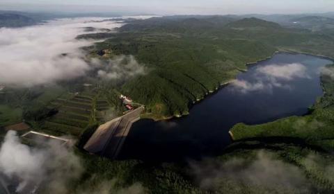
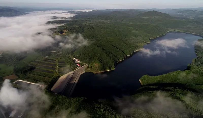
Hunhe Reservoir Photo by Sui Xiaodong
Hunhe sticker
Text|Cheng Yuan
The Master said on the river: The deceased is like a man who never gives up day and night.
Gunmaling
The charm of mountains, rivers and land, in addition to the miraculous workmanship of God’s hand, is also inseparable from history and legends. Rolling Maling is named after General Xue Rengui of the Tang Dynasty who accidentally rolled his horse because he was greedy for the scenery in front of him during his Eastern Campaign. At the foot of the ridge, a clear water flows out from the gaps between the horizontal and vertical stones. It passes through the Chazhuang ditch to Wandianzi, crosses Jianshanzi to Taipingtun, joins the Yaoling River and flows into the Ying'e River, meandering all the way. Eventually, a broad and clear river was formed, passing through Fushun, passing through Shenyang, and flowing into Liaodong Bay at Yingkou.This is the mother river of the people of Liaoshen - Hun River.Similarly, the origin of the name Hunhe River is also a legend.One day four hundred years ago, Li Chengliang led a Ming army of 200,000 troops from Shengjing, Liaoyang, and Xingcheng to attack Jianzhou in three directions. Nurhaci, who had only tens of thousands of troops at the time, knew that he could not resist, so he led his army across Longgang Mountain, along the Red River water system, detour to the areas of Bajiazi, Beisanjia, Cangshi, and Nanzamu, waiting for work and looking for fighter opportunities. At this time Tan Ma came to report: The front of the Ming army would reach Sarhu and Tiebei Mountains in another eighty miles. Looking at the surging river, Nurhachi came up with a plan. He ordered tens of thousands of soldiers and horses to go into the river. While letting the horses drink water, he drove the horses to run up and down the river. At the same time, he ordered the entire army to mobilize the people along the river to spread all their horse dung into the river. For a while, the crystal clear river was stirred up with sand, horse dung floating, and the sour smell was even worse. It was flying in the wind, as if thousands of troops had just crossed the river, which puzzled Li Chengliang who was stationed downstream. He thought that Nurhachi had many troops and was unfamiliar with the surrounding environment, so he did not dare to fight, so he could only retreat.Nurhaci looked up to heaven and said: The credit for being able to scare away the Ming army today is due to "Hunhe"!Do you believe this? Anyway, I believed it.I have been to the source of the Hunhe River four times, once with a friend who likes geology, once with a few childhood friends, and again the summer before last year with the poet A Jian and the traveler Sun Min Sun Lei who were visiting Beijing. The most recent time Last spring, I participated in the Liaoshen Writers Group’s gathering activity. The reason why I am willing to come here over and over again, I think, is not only the legend, but also the mountain breeze and tree shadows, the singing of flowers and birds, the fresh air, the well-proportioned three pools of clear water, and the red and white birches standing on Longgang Mountain. Poplar, oak, basswood, locust, cypress, spruce, rare willow and elm trees all attract me all the time. Although the mountains are high and the roads are far away, the car driving is like a roller coaster. This, perhaps, is the joy of traveling!Yang Wanli has a saying: There are dust stains and wine stains on the clothes, and the soul is gone everywhere when traveling far away. Ajian also said to go far away and travel. Those factors in travel, after the noise, are quietly turning into their extended realm.
Hunheyuan Photo by Cheng Yuan
A Jian, Sun Min, and Sun Lei inspect the source of the Hun River. Photo by Cheng Yuan
Hunhe Sui Xiaodong - photo
Hongtoushan
The Hun River running all the way from Gunma Ridge not only carries the legend of Nurhachi, but also has the temper of the old Khan. That is, the river flows eastward, and I pass the water westward, changing people's general understanding of rivers along the way. .In fact, when she came out of the mountains and ridges and reached Qingyuan County, her flow was already very gentle. Especially when she reached the Cangshi area, she looked like a young woman, and she became more and more graceful and luxurious.Cangshi means white-haired fox in Manchu. It is a natural village under the jurisdiction of Hongtoushan Town, which is an industrial and mining town with rich resources. Nonferrous metals such as copper, zinc, sulfur, gold and iron have been mined. It is said that Hongtoushan was originally called Hulutougou. There are two theories about how it was changed to its current name: 1958 Year 10 Geological Exploration 101 The team discovered a mine in the ditch, and when reporting to the superiors, they were in a dilemma. They couldn't just write Hulutougou, right? The mine geological staff, with the approval of the mine director Zhao Qingcai, named it according to the spirit of "red, thorough, specialized and deep" advocated at the time. Secondly, this place is known as the "Gold Mountain and Copper Ridge", and the rich mineral deposits have made the mountains red and thorough, so the name is naturally easy to come up with. Of course, this is all a product of history, and it clearly bears the mark of an era. The reason why I take the trouble to write these down is because this is my second hometown, from 1983 Year to 1998 I have lived here for a whole year. 15 Years, going to school, working, getting married, having children, it can be said that this is the most important time in life.With the gradual depletion of mineral resources, I am like a floating boat, drifting down the river and wandering in other places.Today, I prefer to compare Hongtou Mountain to a fisherman staying on the bank of the Hun River. Drinking, yawning, and snoring the sun are his daily routine. The scenery of the past has disappeared, or it has become calmer.Of course, I often come back here and swim upstream along the Hun River, looking for the footprints and memories I left behind in the past fifteen years——School, well tower, dressing plant, U type bucket for transporting ore, dispatch room, government office building, trade union gallery, "Mining News" run by the Propaganda Department, radio station, towering chimney of the smelter, The small train that pulls both ore and people, the mine park and the yellow mud hut at the foot of the mountain, T-junction, Lao Niu's small restaurant, Fu (Shun) Dan (Dong) store, lighted stadium, single building, club, filmed TV series 101 Gounnanshan Street, criminal suspects who had their heads shaved and trousers cut during the crackdown period, old women pulling carts selling spring water, men's and women's basketball teams, workers' art troupes, etc., etc. One thing is enough. They are the places where I have worked and lived, as well as my relatives, friends and classmates. They are also the footnotes of a river, the fine texture, the smooth pebbles and the underlying pearls.
Fortunately, I have written these in "Hongtou Mountain: A Person's Dictionary".
Hongtoushan Mining Area Photo by Cheng Yuan
Mining shaft tower - photo by Cheng Yuan
A Jian, Sun Min and Sun Lei in the mining area. Photo by Cheng Yuan
Salhu
Sarhu, in Manchu, means that this mountain has dense forests and abundant products, which are inexhaustible. It is now a key scenic spot in Fushun City, including eight tourist areas: Bailong Mountain, Wanggao Mountain, Degu Bay, Lianhua Island, Yingpan Island, Salhu Mountain, Marshal Forest, and Tiebei Mountain. Each tourist area is unique. Characteristics, each has its own merits.In the early 1980s, my first trip was to participate in a school summer camp.At that time, Salhu was not called Salhu, but Dahuofang Reservoir.A group of middle school students drove toward the dam in a bus from a distance. Before they could see the dam clearly, the teacher asked them to read the words written on the dam: Let the mountains bow their heads and let the rivers give way. The teacher said that this was Chairman Zhu De’s inscription. The students echoed the words, but what they were thinking about was going to the reservoir early to take a boat ride, put their feet into the water, and touch the swimming fish.I have been to Dashufang Reservoir several times since then, but always to Marshal Lin. There is Zhang Zuolin's mausoleum here. The complex of buildings is quite large. No wonder he was the king of the Northeast. Especially the Ming and Qing stone carvings inside are said to have been transported by Zhang Xueliang from the capital, and their artistic styles are all excellent. The entire building complex is located on the hills of the Hun RiverS-shaped Dadaiwan. The tall city wall is a square building with forts at the four corners. A huge mound under the towering archway is Zhang Zuolin's mausoleum. After Zhang Zuolin was murdered by the Japanese in Huanggutun in 1928, the Zhang family sent many Feng Shui masters to search the famous mountains and rivers in the Liaoshen area to find his grave. It is said that the reason for choosing this place is that "it has Tiebei Mountain in the front, Jinlong Bay in the back, Fenghuang Lake in the east, and golden beach in the west." There is no doubt that this is a geomantic treasure. In the autumn of 1931, just as the construction of Marshal Lin was beginning to take shape, the September 18th Incident broke out. Zhang Zuolin's remains were buried hastily in Panjin's Yimafang before they could be transported.Therefore, this is just a tomb.Standing on the stone steps in front of Zhang Zuolin's mausoleum, you can see Tiebei Mountain on the other side. Although the mountain is not high, it is steep and majestic. And because it is surrounded by water on three sides and connected to other peaks on one side, there is no way to go up, so very few people go up.Tiebei Mountain was called Jiefan Mountain in history, which means the intersection of two rivers. To the south of the mountain is the Suzi River, which originates from Xinbin, and to the north is the Hun River, which originates from Qingyuan. The two rivers flow through the west side of Jiefan Mountain and merge into the Dahuofang Reservoir with magnificent blue waves.On the top of Tiebei Mountain is the second capital of the Qing Dynasty and Later Jin Dynasty built by Nurhachi, the emperor of the Qing Dynasty. The famous Salhu War in history took place in the Salhu area in the southwest of the mountain.According to historical records, Nurhachi established the Later Jin Dynasty in the forty-fourth year of Wanli (1616), and two years later he attacked the Ming Dynasty and captured Fushun and other places. The Ming government appointed Yang Hao as the general manager, and in the forty-seventh year of Wanli (1619), he led the army to attack in four directions. Later Jin gathered 60,000 troops from the Eight Banners, and first defeated the 30,000 Ming main force of the Dusong tribe in Saarhu, and then returned to defeat Ma Lin and Liu Ting (纺+tent, do not show it, use Ting instead)Two armies. Except for Li Rubai's army, all the Ming army was destroyed. After this battle, Ming Dynasty could only go on the defensive against Hou Jin. "Manuscripts of the History of the Qing Dynasty" commented on this battle like this: "In the battle of Saerhu, Jian Shang was decided. The capital was moved to Shenyang, and the scale was far away. Compared with Yuqi and Feng, there was not much to give." Emperor Qianlong, who was good at summarizing historical experience, was also emotional. The emperor wrote: "At that time, the grass was created and the foundation was opened. The roads were blue and blue. The earth was not full of thousands. The number of soldiers was tens of thousands. But father and son, monarch and ministers, worked together as one heart. The teacher is straight and strong. The dragon in the sky. Use the power to break it. There are two hundred thousand people in the Ming Dynasty. Every time I look at the record, I am moved to tears. I also remember the efforts of the ministers at that time." At the end, there is a poem:They annihilated Juniper on the top of Tiebei Mountain, and raised the army's front with the yellow ax in their hands. Today, there is no battle in the four seas, leaving a trace of the difficult creation.Of course, these are all vague memories of the past.Nowadays, whether you are standing on the ruins of Jiefan City or on the top of Tiebei Mountain and Sarhu Mountain, overlooking the slowly flowing Suzi River and Hun River, you may think of the famous saying of Confucius: The deceased is like a man who never gives up day and night. Even the most tired river, after all its twists and turns, will eventually reach the sea safely. is for recording.▋Originally published in the 2020 issue 9 of "Mang Zhong" and "Sinking Beauty - Hunhe River Collection Works of Liaoshen Writers "Two Banks of the River, Happy Shenyang"", Shenyang Publishing House
Saarhu in winter Photo by Cheng Yuan
Ming and Qing stone carvings in the Marshal’s Mausoleum, photographed by Cheng Yuan
The birthplace of the Hun River - Qingyuan Wandianzi Forest Farm Photo by Sui Xiaodong
Suzi River Dazhuan Bay Photo by Sui Xiaodong
Dusk in Hunhe River by Zhang Guoyong-Photographed by Zhang Guoyong
Night on the Hunhe River Photo by Li Yun