China Border Self-Driving Tour: Border Patrol Beyond the Great Wall Day 19 Fuyuan-Jixi

In other words, I have to walk three times from Fuyuan to Dongji Pagoda.
So arriving late last night was a mistake.
Today, we will continue our border patrol. The Dongji Pagoda is on our route, so it can be called a drop-in.
When we arrived in Fuyuan yesterday, my second uncle, the commander-in-chief of the vanguard, had already rushed to Tieling in one breath. In this way, even if the Vanguard is completely disbanded, I will have to explore the future path by myself.
Although I am completely used to traveling alone and am familiar with the roads, I am still a little worried about how the epidemic will play out and how local policies will change.
For example, whether I can successfully check into Jixi tonight will be a question mark, but at this moment I can only bite the bullet and move forward.
At 7:50 in the morning, we set off on our journey to Dongji Pagoda.
Dongji Pagoda is not far from Fuyuan and is located on Heixiazi Island. A bridge crosses the Heilongjiang River and connects Heixiazi Island to the mainland.
When we drove 35 kilometers and took 40 minutes to reach the bridge, we found that the bridge was closed.
I got off the car and asked the staff. The staff said that the bridge had been closed for a week and no one was allowed to enter.
Am I destined to not be able to see the northernmost point of this continent?
But now I have nothing to do, what can I do? The only option is to turn around and return.
But how did my second uncle and the others find "Dong" yesterday?
Unconvinced, I quickly dialed his number. It turned out that they didn't go to Chengheixiazi Island yesterday. Instead, they went to Dongji Square, not far east of the bridge.
Ah, isn’t the Dongji Pagoda in Dongji Square? I always thought they were together!
I'm dizzy. There's something wrong with my homework.
After thanking my second uncle and wishing them a smooth journey, I quickly changed the navigation destination from "Dongji Pagoda" to "Dongji Square" and set off immediately.
In fact, the longitude of Dongji Pagoda is greater than that of Dongji Square, but because Heixiazi Island has been separated from the mainland by Heilongjiang, the easternmost point of the entire mainland of China is naturally located in Dongji Square.
7 or 8 minutes later, we arrived at Dongji Square smoothly.
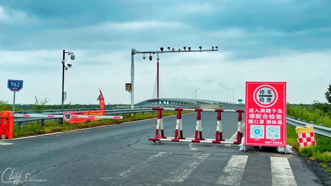
The bridge in front leads directly to Dongji Pagoda, but it is unfortunately closed.

It turns out that the easternmost point of continental geography is here
Video: Early in the morning, we planned to go to Dongji Pagoda. We originally thought that Dongji Pagoda was on Dongji Square, but unexpectedly the navigation led to Heixiazi Island. When we walked to Black Box Island, we found that the island was closed. We had no choice. Next, I had to call my second uncle, and then I realized that I was in the wrong place.
*************************************
Before we reached the square, we saw a huge "东" character standing there from a distance, just like what we saw in the "North" character square in Arctic Village.
The location of the square is very special. It is right on the tip of the easternmost tip of the mainland. Here, the Ussuri River merges into the Heilongjiang River. On the outer banks of the two rivers, there is Russia's territory.
We came to the bottom of Dongzi and clocked in like crazy here. You know, when we arrived at Beizi Square and found the north, and when we came here we found the east again, we have really been to the north east or northeast.
After checking in, we came to the edge of the Ussuri River. Here, we fulfilled our mission of patrolling the border for the country and looked hard to see if Russia on the other side was up to anything. Of course, Russia did not dare to do any tricks, so we walked along the Ussuri River to Heilongjiang with confidence.
Of course, this is only a few dozen steps away.
This is where the Wusuli River flows into the Heilongjiang River. The two rivers meet and the water is open. Standing here and looking eastward, it feels like you are looking at the sea.
Here, there are also interesting landscapes: the Wusuli River is clear and green, while the Heilongjiang water is dark and yellow. The two waters intersect with clear lines and clear boundaries.
Several small fishing boats were moored on the shore. The fishermen on the fishing boats were sitting on the bows, frowning. It seemed that the heavy water had affected their harvest.
There were people fishing on the shore, but they didn't catch a single fish during the ten minutes we stayed. I wonder if all the fish were washed away by the flood.
Continuing to turn north along the shore, there is a bridge across the river not far away. It is the closed bridge to Heixiazi Island. Looking at it from here, the bridge is very majestic and handsome. It stands at the easternmost end of our country, showing the strength of our eastern country.
After finishing the trip, we returned to the parking lot, boarded the car with satisfaction, and drove away.
From here, we'll head south and west, and each day we'll be a little warmer and darker than before.
From here on, it felt as if I had officially embarked on my journey home. This feeling was very comfortable and a steady sense of happiness.
National Highway 331 is still far away from here, so we took County Road 101 and headed south along the Wusuli River.
Next, I will walk along the path along the Ussuri River and continue patrolling the country’s borders.

The huge "东" character on Dongji Square, the straight-line distance from Shanghai is 2,200 kilometers


Looking over the Ussuri River


Let’s see if Russia on the other side is up to anything.

Ahead is the intersection of the two rivers


cloister in the square


This is our boundary marker No. 260


"East" on the railing on the shore


Heilongjiang and Ussuri Rivers are clearly separated

small fishing boat


Going around to the north, you will see the wide Heilongjiang River. The bridge not far away is the Heixiazi Island Bridge.

Looking back at the Great "East" here


After leaving Dongji Square, I was attracted by the swamp full of flowers on the roadside, so I stopped to take pictures.
Video: After walking around Dongji Square, we set off successfully. However, we did not return to National Highway 331 immediately. Instead, we chose a secret path and planned to walk along the Wusuli River and gradually approach the Changbai Mountains. edge
*************************************
Along the path, walking on the plains formed by the joint efforts of the Heilongjiang and Wusuli rivers, walking through the prosperous rice fields, the sky is vast and the sea is vast, and the heart is relaxed and happy.
Slowly we came to a village called Hai'an Village. There was a railing blocking the entrance of the village. Next to the railing was a disaster relief tent with three big men standing beside the tent.
A little uneasiness lingered in my heart.
Walking over, a big man waved and stopped the car. In fact, he didn't wave, so I had no choice but to stop. After all, the railing was there to stop me. But it can be seen that they are also quite polite.
What's the matter? I asked.
Of course, it means asking questions knowingly.
For epidemic prevention inspection, please show your ID card and itinerary code. He said.
I obediently took out my ID card and handed it to him, then fiddled with the itinerary code.
When the other person saw that I was from Shanghai, he immediately frowned.
Are you from an epidemic area? he asked, looking straight at me.
Epidemic area? The epidemic area is near Pudong Airport, so we are far away. I explain.
No, no, no one from the epidemic area can enter our village.
After saying that, he handed the ID card back to me and asked me to turn around quickly. That look in his eyes and his attitude were absolutely non-negotiable.
I had no choice but to turn around.
Why are they so simple and crude? Leo was very confused.
Because they are a small village, they do not have strong identification capabilities, and they lack the epidemic prevention resources of big cities. They can only rely on simple and crude methods to prevent the epidemic from entering the village. Understandable. I explained to him.
No way, we can't patrol this small piece of national border that protrudes eastward, so we should take a detour.
In fact, the detour was shorter and easier to walk than the original route, because we soon came to the national highway.
At 11:23 am we were back on the original route and the detour ended.
Along the way, we passed many towns and villages, but in fact, these are not towns and villages in the typical sense of the mainland. In fact, they are all farms and their affiliated production teams.
In the vast black soil of the Northeast, the quality of crops such as rice, soybeans, and corn is significantly better than that in other areas, forming a brand effect across the country. As a result, agricultural production has become a more profitable enterprise. Slowly, An intensive agricultural production model was formed.
Here, you can often see various farms, such as 290 Farm, Seven Star Farm, etc., and each farm has several production teams.
As the population engaged in agricultural production gathered and multiplied, farms gradually turned into towns, and production teams turned into villages.
But only in terms of settlement form, its production model is still very different from the small farmer model of villages in the interior.
At 12:30 noon, we arrived at Raohe Farm, which is now the size of a small county town. There are many shops on the streets and a lot of people coming and going.
Except for the farm machinery passing through the streets from time to time to remind us that this is still a farm, you can no longer see the difference between it and the city.
We happened to be hungry, so we found a restaurant on the street and stopped. The three of them ordered a dry-pot cabbage, a mapo tofu, and a braised pork.
These dishes don't look like local Northeastern dishes, but for some reason, we just want to eat these dishes.
When the food arrived, don’t tell me, it’s not bad. The spicy cabbage is spicy enough, the mapo tofu is numb, and the braised pork is a Shanghai specialty. The rich red sauce has just the right amount of sweetness. It’s really satisfying. People are a little impressed.
You see, this chef is not simple.
After finishing our meal, we continued along National Highway 331.
Next, we want to go to Zhenbao Island.

403 Township Road


Ripening rice on the side of the country road

National Highway 331 running through the "Black Plains" (of course I came up with this name, hehe)

Check out the chef's skills
Video: I originally planned to walk along the path along the Wusuli River, but I was dissuaded by the epidemic prevention personnel at a certain village entrance, so I had to continue back to National Highway 331, but I didn’t give up. I still wanted to return to the secret path as much as possible. If I walk close to the border, will it be okay for me?
*************************************
Zhenbao Island is a small island on the Ussuri River. It was not well-known at first. However, the Soviet invasion of Zhenbao Island on March 2, 1969 suddenly made this island a place of concern to people across the country.
Since Zhenbao Island is on our route, we wanted to stop by and have a look.
The road in the afternoon alternated between rural roads, county roads and national roads.
National Highway 331 is a new national highway, but it is not a road planned in advance and newly built. It is formed by absorbing the roads in the original border areas and connecting them together. Therefore, it is characterized by twists and turns. The route I chose was to get as close as possible to the Ussuri River and its flow. Therefore, sometimes we would walk on the national highway, and sometimes we would walk on the small road I chose.
Even if it is a small road, it is not too far from the national highway. There are more or less small lines in the middle that are connected to the national highway, so even if the road is cut off, you can quickly get back to the national highway.
In fact, we did encounter broken roads. In a small village, a small rural road was cut off for some unknown reason. A trench more than one meter deep appeared in the middle. There were piles of earth and rocks beside the trench. Obviously, this I was not allowed to leave, so I had no choice but to find a path through the dense forest and return to the national highway.
The whole process only takes 20 to 30 minutes, which is not a big delay. If we are stopped by the Songhua River like yesterday, we will be really in trouble.
It went quite smoothly. At 3:30 in the afternoon, we arrived at Zhenbao Island in the Wusuli River.
In fact, we did not come to Zhenbao Island, but to the Ussuri River not far from Zhenbao Island. From here, you need to take a ferry to get to the island.
Of course, we didn’t go to the island. Firstly, we didn’t have much time, and secondly, we were not allowed to go on the island for some unknown reason.
So we took a rest by the river and looked at Zhenbao Island.
The island is covered with dense forests and lush trees. Houses are being built in the area facing us. It looks like a resort. Maybe in a few years, Zhenbao Island will become a popular resort.
After staying here for 20 minutes, we continued our journey to our next destination—Hutou Fortress in Hulin County.

a county road


As we continue to move forward, we gradually come to the edge of the Changbai Mountains, where we can see some low hills.


When we encountered a broken road, we chose a small road to go to the national highway. Unexpectedly, the road conditions on the small road were not bad.

Birch forest on the roadside
Finally arrived at Zhenbao Island
monument
Aunts will always be the most lively cultural landscape in the world

Well, that’s Zhenbao Island
Video: We followed the route that intertwined national highways and small roads. Although we occasionally encountered broken roads, we quickly returned to the main road, so it was quite smooth. At 3:30 pm, we arrived at Zhenbao Island.
*************************************
In fact, I didn't know what this Tiger Head Fortress was. During lunch, the hotel proprietress asked me where I was going. I said to Jixi, and she said that you can visit the Tiger Head Fortress on the way.
She said that the Tiger Head Fortress was built by the Japanese and there were many tunnels in it that you could check out.
So, I half listened to people’s advice and made Tiger Head Fortress a point on my itinerary, and it was indeed on my route, so I didn’t need to spend extra time on the road.
After leaving Zhenbao Island, I walked along the riverside path through the dense forest, then returned to National Highway 331 and continued heading south. At 5 pm, we finally arrived at Hutou Fortress.
But still, the fortress closed at 5pm!
What a coincidence!
In desperation, we had to park the car in the square in front of the Hutou Fortress Museum and come down to rest.
There was no car in the square and it looked quite deserted.
To the north of the square is the museum, which is also the entrance to the fortress, and to the south is a sculpture of anti-Japanese heroes. There are Chinese anti-Japanese heroes in the sculpture, as well as Mongolian and Russian heroes.
We remembered the anti-Japanese martyrs here for a while, and Leo even saluted the sculpture. After that, we got in the car and continued walking to Hulin.
Originally, I planned to live in Hulin and then go to the famous Xingkai Lake tomorrow.
Xingkai Lake is a big lake, but only a small part of it is within our country. On this side of the country, there is a landscape avenue that crosses the lake. It feels very good to drive on it.
If you raise the plane and follow it intelligently, you will be able to take some good blockbusters.
However, when I contacted the hotel, the hotel said that we could not check in in this situation. In desperation, I had no choice but to look further ahead. After confirming that the hotel in Jixi was available, I changed my destination to Jixi.
As a result, Xingkai Lake will no longer be visible, and we will have to walk at night today.
But fortunately, there is a section of highway from Hulin to Jixi called "Jihu Expressway", which gave me peace of mind.
How about Jihu Expressway? Isn’t the name awesome?

After leaving Zhenbao Island, we continued along the path. Unexpectedly, we soon encountered a cow jam.


This section of the road still passes through dense forests, but the terrain here has greatly undulated.


When we arrived at Hutou Fortress, it was a pity that it was closed after get off work.

Anti-Japanese hero sculpture
Video: From Zhenbao Island through the jungle, we came to Hutou Town, Hulin County, where the Second World War ended. Here, we remembered the martyrs, and then we set off on the journey to Jixi
*************************************
After continuing on National Highway 331 to Hulin, we got on the Jihu Expressway and rushed all the way to Jixi.
It was already 5:50 pm when we got on the expressway, and we still had 2 hours to go.
The sun was already going down, but at this time, the clouds in the sky were getting thicker and thicker, so the sky quickly became dark.
This kind of weather is very unpleasant, but fortunately our day's trip is almost over. In 2 hours, we will hide in a comfortable hotel, so we feel good in our hearts.
As I was walking, I saw a huge black cloud hanging in the sky in the distance. Under the black cloud was a pearly curtain of clouds. I suddenly realized that it was not clouds, but heavy rain.
On July 30, we had seen such black clouds and heavy rain on the Hulunbuir Prairie, but when we walked over, the clouds had fled the scene quickly, and the heavy rain had also fallen. We had never experienced such a thing. The process of heavy rain from nothing to something and then from something to nothing.
Today, this black cloud happens to be on the highway, and we will have the opportunity to experience such a process.
I quickly asked Leo and the sleepy Isa to cheer up.
When everyone heard that there were heavy rain clouds ahead, they immediately stood up from their seats, stretched their necks, and stared straight ahead.
As we got closer to the black cloud and its string of pearls, drizzle began to fall.
The drizzle is immediately followed by light rain, moderate rain, heavy rain and heavy rain.
The whole process definitely took less than 1 minute, but it allowed us to clearly see the process of the rain increasing from small to heavy.
Everyone was amazed and said it was so enjoyable.
The dark clouds were not big, and after the heavy rain continued for a few minutes, it slowly turned into heavy rain, then moderate rain, light rain, drizzle and no rain.
When the rain stopped at all, the sky returned to what a normal evening sky should look like, as if everything had never happened.
Looking back from the rearview mirror, the black clouds are still there for those who come later to continue to experience this rare sight.
As we continued on, it was getting dark, and there was only one thing left to do: hurry.
At 19:19 in the evening, we got off the highway; at 19:49, we arrived at the hotel smoothly.
Well, a pretty perfect day!
Leaving Hutou Fortress and heading to Hulin, the sun is almost setting.


When I was approaching Hulin, I saw "Tindall", so I quickly stopped to take pictures.

I continued walking and saw the windmill array, so I would definitely have to stop again.


Man, I just like taking pictures of windmills
Video: On the highway from Hulin to Jixi, we were attacked by a heavy rain cloud. Now, let’s see how it attacked us.
This is the day's trajectory (blue) VS route (other colors)

From Fuyuan to Dongji Square

You see, Dongji Pagoda is not far from Dongji Square, but unfortunately it has been separated from the mainland by Heilongjiang (the map has been shifted)

Leaving Dongji Square and heading south, I originally wanted to walk along Wusuli Price, but was persuaded to turn back at the yellow circle.

Along the way, we had lunch at Raohe Farm, and then came to Zhenbao Island

The path (red) to Zhenbao Island was dug up in a village, so we had to take a detour on National Highway 331, but fortunately, the detour time was not too long.

From Zhenbao Island to Hutou Fortress

From Hutou Fortress to Hulin, the oval-shaped lake on the way is Xingkai Lake
Discover More
Comments
No comments yet
![[Travel Note Sharing] 2018 Kyoto Red Leaves + Utada Hikari Live (2)](https://bh2255.static.gitbeta.eu.org/bh2255/body_images/frc-e92c7d24a1507fed4a96dfa3261486d8.jpeg)