Denali Hiking Route Summary
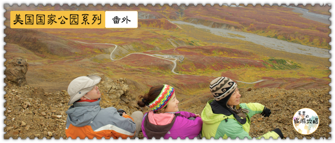
This article is a spin-off of the American National Parks Series Vol. 5: Denali National Park.

To better appreciate the beauty of Denali, just sitting on the shuttle bus is not enough. Only hiking can allow you to better appreciate the magical beauty of nature here.
There are two types of hiking in Denali: you can choose to take their trail (plank road), or you can take the off-trail.
1. Trail Hiking
Although Denali Park is about the size of Massachusetts, hiking trails in such a vast park are very limited.
As of May 2021, there are only 20 official hiking trails in Denali Park. Details can be found at:
HTTPS://wuwuwu.nanpingcity.gov/dena/plan人visit/day hiking.htm
And most of the hiking trails are at the entrance, are less than 2 miles long, and are relatively easy to navigate.
This is because one of the goals of Denali Park is to allow people to explore nature on their own, so the park strongly encourages the second type of hiking, which is off-trail hiking.
2. Off-trail Hiking
Leaving the park’s established trails and exploring the endless possibilities sounds both exciting and scary.
Personally, I think off-trail is more interesting, but it requires a higher sense of direction. Some people once almost got lost while walking.
PS: Don’t forget to ask the ranger in the park for information about off-trail before setting off.
When we were staying at Wonder Lake, we met an American couple who kindly lent us a book about various trails in Denali National Park, which introduced hundreds of trails. While I was reading with gusto, the Wonder Lake campground administrator reminded me: Although the book said that Wonder Lake has 5 or 6 trails, there is only one official trail here, which is the McKinley Bar Trail, and the rest of the trails are either They discovered it themselves, or they planned to build a trail but it has not yet been completed. You may find that the trail disappears as you walk, and you need to trek through the bushes by yourself~~
My hiking is a combination of trail and off-trail. Of the 20 existing trails, I walked 3 of them, namely the Tundra Loop Trail, the Thorofare Ridge Trail and the McKinley Bar Trai. I recommend everyone to give it a try.
Ranger Program
I strongly recommend everyone to participate in the ranger program here! It comes in two varieties:
a. Guided Walks: The park provides some short hikes led by rangers every day. They are long or short, and you can choose according to your own needs. The number of people is limited, first come first served, sign in and gather at the designated place at the designated time to set off. This guided walk is only available at Denali Visitor Center (entrance) and Eielson Visitor Center (MP66).
b. Discovery Hike: This is a full-day activity led by ranger, going to a different place each time. It clearly states: Hikes take place off-trail and can be difficult. So please weigh it before deciding whether to participate. You need to book this in advance at the Denali Visitor Center and buy a bus ticket to the depths of the park.
PS: We originally wanted to participate in this, but then gave up due to lack of time. But I took part in ranger guided walks near Eielson Visitor Center.
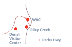
The brief terrain at the entrance is as follows. As long as you remember the approximate locations of the visitor center, WAC, and Riley Creek campground, you can identify the approximate locations of each hiking trail.
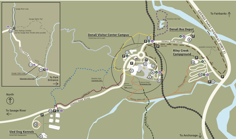
The detailed map is as follows:
1) Roadside Bike Trail
Location: On Denali Park Road, between the park entrance and the visitor center.
Difficulty: Easy. The trail is surfaced with gravel.
Length: 1.7 miles one way, only 45 minutes
2) Horseshoe Lake Trail
Location: Trail around Horseshoe Lake, a 15-20 minute walk northeast of the Visitor Center
Difficulty: Moderate, the trail is wide (5 feet) but dirt.
Length: Loop 2 miles round trip, 2 hours (2.5 hours if walking from the Visitor Center)
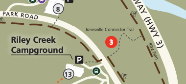
3) Jonesville Trail
Location: Near the entrance to Riley Creek Campground, which is a shortcut from the campground to Canyon
Difficulty: Easy
Length: 0.3 miles one way , only 10 minutes
4) McKinley Station Trail
Location: Near the visitor center, leading to Hines and Riley Creek
Difficulty: Moderate, this is a gravel trail with only 150 feet of elevation change.
Length: 1.6 miles one way , 1 hour
5) Meadow View Trail
Location: Connecting Rock Creek and Roadside Bike Trail
Difficulty: Moderate. The road is narrow and gentle, with only one steep spot.
Length: 0.3 miles one way, only 15 minutes

6) Morino Trail
Location: Next to the visitor center. The official description is that this is a "good place to kill time while waiting for the bus."
Difficulty: Easy
Length: 0.2 miles one way , only 15 minutes
7) Spruce Forest Trail
Location: Next to the visitor center. The official description is that this is a "good place to kill time while waiting for the bus."
Difficulty: Easy
Length: 0.2 miles one way , only 20 minutes
8) Oxbow Loop Trail
Location: The entrance to this boardwalk is east of Route 3, 7 miles south of the entrance. The plank road leads to the Nenana River, which is a secret garden for rafting enthusiasts.
Length: 1.5 miles round trip , 1 hour
9) Parks Hwy Bike Trail
Location: A single lane, paved road along Route 3
Difficulty: Easy
Length: 1 mile one way , 30 minutes
10) Roadside Hiking Trail
Where: Trail from the visitor center to Sled Dog Kennel.
Difficulty: Moderate
Length: 1.8 miles one way , 1 hour
11) Rock Creek Trail
Location: It has the same starting point and end point as the Roadside Hiking Trail and is parallel most of the time. Rock Creek Trail is longer and quieter.
Difficulty: Moderate
Length: 2.4 miles one way , 1.5 hours
12) Mount Healy Overlook Trail
Location: Go straight up the mountain from the Taiga Trail near the visitor center, from the forest landscape to the alpine country. If the weather is good, you can directly see Mount Denali.
Difficulty: Hard. This is a dirt road and very steep
Length: 2.7 miles one way , 2 hours
Oddly, although the Taiga Trail (yellow route) is marked on the map above, the Taiga Tail is not one of the 20 official hiking trails published on Denali's official website.
13) Triple Lakes Trail
Where: Starts at the Visitor Center and ends on Highway 3, 7 miles south of the park entrance, near the Nenana River.
Difficulty: Difficult. It is the longest hiking route in Denali Park. The slope reaches 20 degrees in some places. It is a mixture of dirt roads and gravel roads.
Length: 9.5 miles one way , 5 hours
Savage River is at MP13-15. You can drive here by yourself or take a shuttle bus.
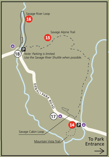
14) Mountain Vista Trail
Location: The entrance is next to the shuttle bus station
Difficulty: Easy
Length: Loop 0.6 miles round trip , only 30 minutes
15) Savage Alpine
Location: The starting point and end point are both shuttle bus stations, so you only need to go one way
Difficulty: Difficult, the slope reaches 25 degrees in some places.
Length: 4 miles one way , 3 hours
16) Savage River Loop
Location: The entrance is next to the shuttle bus station
Difficulty: Moderate
Length: Loop 2 miles round trip , 1.5 hours
You can't drive here, so you can only take a shuttle bus.
17)Tundra Loop
Location: Next to the Eielson Visitor Center
Difficulty: Easy
Length: Loop 0.3 miles round trip , only 15 minutes
Although the Tundra Loop is only a very short hike, at the end of this trail is connected to another unofficial hiking trail-Tundra trail. If you are interested, you can read my hiking story below.
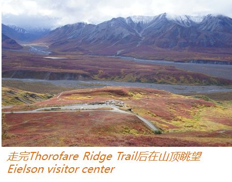
18) Thorofare Ridge Trail
Location: Next to the Eielson Visitor Center
Difficulty: Hard
Length: 0.8 miles one way , 1 hour
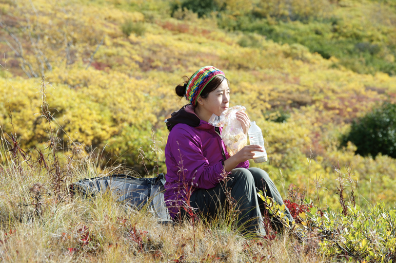
My Tundra Loop Trail & Thorofare Ridge Trail Hike Story
Both of these are in the Eielson Visitor Center area. We took the bus to Eielson early in the morning and found that there were two ranger programs that day:
Thorofare Ridge Trail at 12 noon, the difficulty is strenuous (hard)
Tundra Loop Trail at 2pm, difficulty level is easy (easy)
We discussed it and decided to take the Tundra route and come back at 12 o'clock to participate in the ranger program. So we first registered for the ranger program at 12 noon, and then started walking the Tundra Loop Trail.
This is a short hike, only 0.33 miles, and it takes 15 minutes to complete. It allows you to walk to a small hilltop and overlook the mountains in the distance. There is a sign next to it that says Tundra Trail. This hiking trail seems to have not been completed yet, so it is not among the 17 known trails. We were addicted to walking, so we started to challenge the unbuilt Tundra trail and walked towards the river.
As we walked, we found that the trail was gradually disappearing, so we struggled to open a path through the bushes. When we reached the foot of the mountain, we suddenly found two moose, one big and one small, in the bushes, about 5 meters away from me! What a great photo opportunity! However, considering that animals with children in nature are more ferocious, and we are more concerned about our lives, we had to leave silently until we retreated to a safe distance of 23 meters.
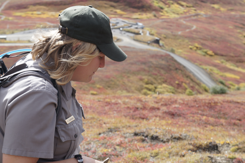
It was 10 minutes to 12 when we came back from Tundra. We packed up and set off with the Thorofare Ridge Trail group, walking up the north mountain from Eielson and starting to climb a 1,000-foot hill.
The ranger who led us is a cute little girl, but her physical fitness is really good! She actually wore short-sleeved clothes at first, but when she was near the top of the mountain, it was windy and cold, so she took her coat on board. When we were exhausted and out of breath, she talked to us while walking and spread some knowledge about the vegetation and animals here. One last sentence: Why are you so quiet~~
Everyone: ...(panting, speechless)
Highly recommend this hike led by a ranger, you can learn some extra knowledge.
19) Gorge Creek Trail
Location: Near the Eielson Visitor Center, trails leading to Gorge Creek and Thorofare River Bars, which are also connected to many other unofficial trails
Difficulty: Moderate
Length: Loop 2 miles round trip , 1.5 hours
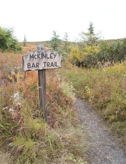
Wonder Lake is in the deepest part of the park and can only be reached by shuttle bus. There is only one official hiking trail here:
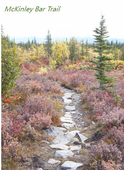
20) McKinley River Bar Trail
Location: Departs from Wonder Lake Campground and leads to McKinley River
Difficulty: Moderate
Length: 2.4 miles one way , 1.5 hours
My McKinley River Bar Hiking Story
Near Wonder Lake, the difficulty is Moderate (medium), but I personally feel it is relatively easy. The entire trail is 2.4 miles and takes 60-90 minutes one way. This is also the only official trail in the Wonder Lake area. This road goes all the way to the river, and you can see McKinley in the distance - but you can actually see it in the distance without taking this trail. My only memory of this trial is the berries on both sides - we picked blueberries along the way, and someone brought a bag of cranberries back to the camp to eat...
It’s hard to summarize this. Basically, it depends on your mood and you can go wherever you want.
In addition to the off-trail next to the Tundra Loop Trail near the Eielson Visitor Center mentioned above, there is also a well-received off-trail that is the Reflection pond trail.
It's near Wonder Lake. Although I haven't walked through it, it looks good from the car. There is a Y-shaped intersection before the shuttle bus reaches the end of Wonder Lake. You can ask the driver to drop you off at this intersection, and then take the branch on the right side of the Y-shaped intersection. After walking for a while, you can see something on the left Go to the starting point of the Reflection pond trail and walk the trail for about 1.5 hours. It is said that this is the only place in the park where you can completely photograph the reflection of Mount McKinley and the Alaska Range - we did not catch the good weather and did not see the complete McKinley. , but I personally feel that the complete reflection should be able to be photographed on the north side of Wonder Lake - this needs to be verified by later generations.
1. Clothing: Waterproofing is very important! ! !
I want to emphasize it here, because it is really important! !
It’s best to wrap your clothing in layers. If it’s too hot for hiking, remove a few pieces and add more if it’s cold.
The most important preparation is waterproof clothes and pants! Because the weather here is changeable, it often starts raining as soon as a cloud floats over your head.
Once when I was cooking noodles in Wonder Lake, I suddenly found a Chinese man running out with his calves bare. I was still sighing at that, the physical fitness of our Chinese people is so powerful, and the old Americans next to me were all wrapped up tightly and wearing hats. To protect yourself from the cold, this girl really exalts the prestige of China!
I heard someone chatting the next day and found out that the Chinese mother and daughter went hiking at Wonder Lake the day before. As a result, a burst of rain came and the mother and daughter were soaked from head to toe. They had no clothes to wear, and that’s why the thing I saw the day before appeared. That scene. After that, the mother and daughter never left the tent again. Others also lamented, how can you come to Alaska to hike with such waterproof measures? Therefore, jackets and waterproof pants are standard equipment for visiting here-unless you don’t plan to hike.
2. Food
There is no food sold in the entire Denali NP, so you have to bring it in yourself. Even if you only plan to come in in the morning and go out in the evening, remember to bring lunch. If you are camping like us, you need to calculate the staple vegetables and fruits you will eat in the past few days and then carry them.
If camping, food should be placed in a special food storage room on the campground. Food must not be placed in your own tent sites to prevent bears from following the scent and coming to you. If you want to hike with food, remember to put the food in the food container to prevent bears from treating you as food. There are many restaurants 1 mile north of the park entrance, where you can go for a good meal in the evening.
3. Bear precautions
What should you do if you encounter a bear? The brochures issued by almost every attraction mention bear prevention instructions. To put it simply, it is:
Avoid encounters with bears
Be Alert: Bears are out and about during the day and night, so be careful and don’t go to the bear’s territory without knowing it, let alone get between the mother bear and her cubs!
Make Noise: Talk loudly, sing songs, and tell bears you're coming while hiking. The bears here are very shy. They will not be overjoyed when they hear your movement - food is coming, but quietly retreat. If you suddenly appear in front of a bear without making any noise, they may become frightened and attack you.
Keep a Clean Camp: Bears are very sensitive to food odors, so keep food away from where you live, seal it in a sealed container, and do not eat where you live to prevent the smell from persisting. In the same way, food brought while hiking should also be placed in sealed containers.
If unfortunately you meet a bear
Do Not Run: Running away triggers a bear’s hunting instinct.
If a Bear Approaches: Stand still and defend your territory while waving your arms to make you look stronger. When the bear turns away, you can slowly back away from the bear.
If a Grizzly Makes Physical Contact, Play Dead: If a brown bear attacks you, play dead immediately.
If A Black Bear Attacks, Fight Back: If a black bear attacks, fight back immediately.
The last two points can be said to be the concentrated expression of the law of the jungle - fight if you can, and play dead if you can't .
Now that we have mentioned pretending to be dead when encountering a brown bear, and fighting back when encountering a black bear, how do you differentiate between a black bear and a brown bear? Color isn't the only distinction - there are brown black bears and black brown bears. I purposely took this photo from the Visitor Center in Denali:
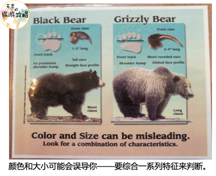
The face is straight
No hump on the back
5 claws are not in a straight line
Nails are shorter
sunken face
hump on back
5 claws in a straight line
long nails
The above is the guide for hiking in Denali.
Comments
No comments yet