I got up at four o'clock in the morning and rushed to Bagan Pier at five o'clock. The cruise ship to Mandalay set sail at 5:20.
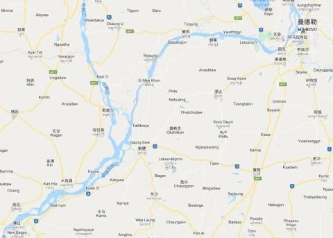
Bagan-Mandalay waterway diagram


The Irrawaddy River is the largest river in Myanmar. It flows through the north and south of Myanmar. It is also one of the largest rivers in the Indochina Peninsula. It has two river sources: the east source is called the Enmeikai River, which originates from the territory of Chayu County, Tibet, China (Dulong River), and the west source is called the Enmeikai River. The Maili Kaijiang River originates from the mountains in northern Myanmar (the Ruili River in China is its tributary). The two rivers were called the Irrawaddy River after they met at Guidao, about 50 kilometers north of Myitkyina City. The entire basin is in the form of a long strip from north to south.
The Irrawaddy River is Myanmar's main domestic transportation lifeline. More than 4,600 kilometers of river channels in the water system are navigable throughout the year, accounting for approximately 71% of the total inland waterway navigation in Myanmar. Most of the precious jade, amber, gemstones and agricultural products from central Myanmar produced in northern Myanmar (even Yunnan, China) are transported to various parts of Myanmar through this river and its tributaries. The waterway from Mandalay to Bagan is in the middle reaches of the Irrawaddy River. It has beautiful mountains and clear waters, and groups of ancient temples and pagodas. It is a golden waterway in Myanmar. Taking a boat here has become a rare experience when traveling in Myanmar.
It was still dark when the boat set sail, which gave me the opportunity to enjoy the sunrise over the Irrawaddy River.


The fiery red sun gradually turned golden, shining the Irrawaddy River brilliantly. The tourists all walked to the bow of the boat, and I also took a photo.


Compared with train tickets and bus tickets, the ticket price of the cruise is higher (35 US dollars). Most of the tourists on the boat are Europeans and Americans, and half of the seats are empty. The seats are widely spaced, which is very suitable for leisure. The boat provides two meals.


Embankments, villages and piers along the way


temples and pagodas


Large ships and small boats encountered


After 11 hours of sailing, the ship finally arrived at Mandalay Port


Mandalay is located on the east bank of the middle reaches of the Irrawaddy River. It is the ancient capital of Myanmar, the capital of Mandalay Province, the second largest city in Myanmar, and the economic, cultural and transportation center of the central region. Mandalay was once the seat of the capitals of the Ava Dynasty, Mingun Dynasty and other dynasties. Ava, the famous ancient capital in Myanmar's history, is located in its suburbs. Mandalay is also called "Wa City". The Pali name of Mandalay is "Radhana Bonni Ghattu", which means "City of Many Treasures". In 1853, King Mindon of the Kingdom of Myanmar launched a palace coup, forced his brother to abdicate and established himself as king. Three years later, Kyoto was moved from Yangon to Mandalay, and a new capital was built here in 1857. From 1885 to 1948, Mandalay was under British colonial rule. During this period, Mandalay was always the cultural center of Myanmar. As the last imperial city and the center of Buddhist practice, it is regarded by the Burmese as the main symbol of sovereignty and national image. After Myanmar became independent in 1948, Mandalay continued to be the cultural, educational and economic center of Upper Myanmar.
As the last capital of the Burmese dynasty, it does not have the hustle and bustle of big cities, but it retains a simpler culture and pastoral scenery, with countless Buddhist sites and historical relics. Here you can enjoy the scene of thousands of monks queuing up for alms. You can also climb to the top of the mountain and overlook the "Thousand Pagodas" of the entire city. You can also stroll around the Royal Palace and feel the glory of the last generation of the dynasty. You can even sit on the U Bein Bridge and enjoy the view. The serenity of sunset. In addition, there are four major ancient city ruins scattered around the city, namely the ancient city of Mingun, the ancient city of Sagaing, the ancient city of Inwa, and the ancient city of Amarapura, which allow people to trace the glorious history of Myanmar.
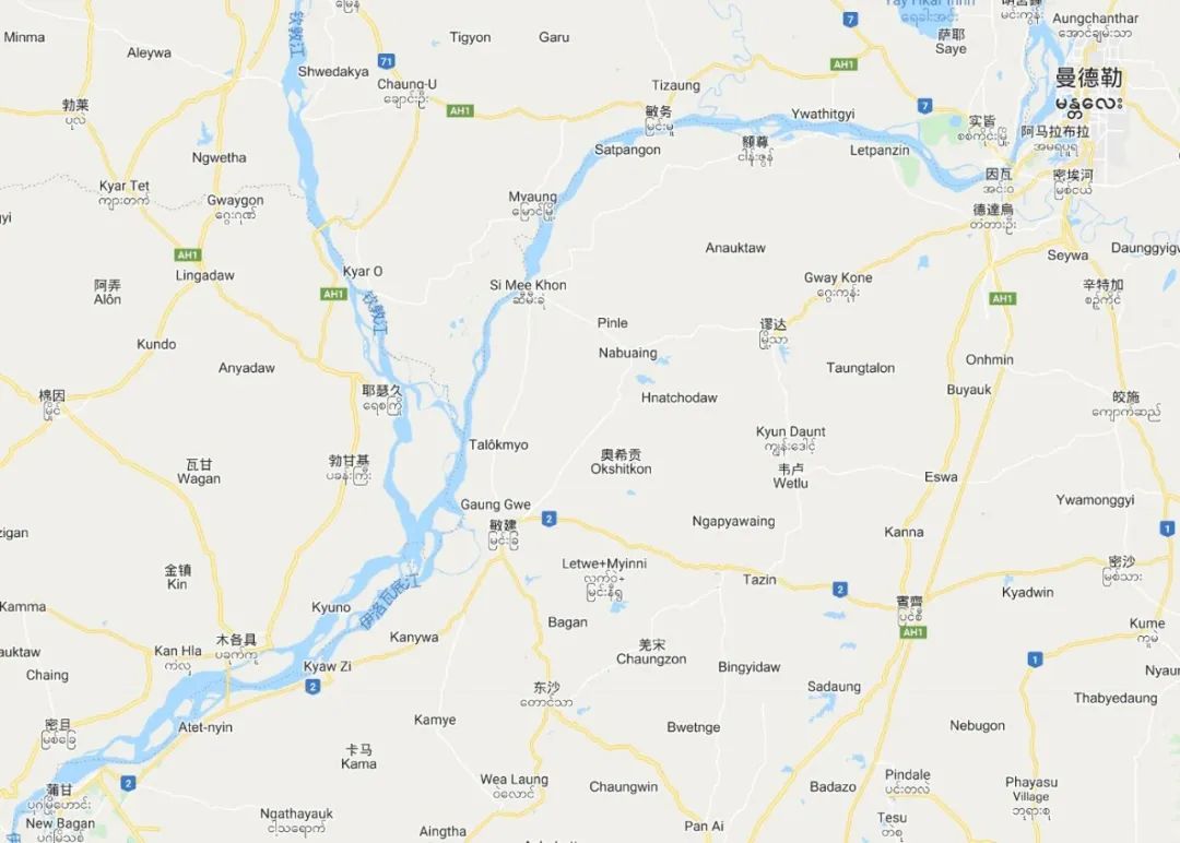
Schematic map of attractions around Mandalay (Qiongyou)

Mahamuni Pagoda is located 3 kilometers south of the center of Mandalay. It is famous for its 4-meter-high bronze gilded Buddha statue that is said to have been consecrated by the Buddha. The bronze statue is said to have been built in the 12th century. Cast in Cambodia, it was originally placed in Angkor Wat. After several twists and turns, it was finally brought back to Myanmar as a trophy and is now one of the most important pilgrimage sites in Myanmar.


Buddha statues are not allowed to be approached


There is a huge pool in the temple, and the pagoda is reflected on the water, which is majestic.


Bell tower next to the temple

My second destination was U Bein Bridge.
U Bein Bridge is located 11 kilometers south of Mandalay city, across Dongtaman Lake. It was built in 1851 and is 1,200 meters long. U Bein Bridge is entirely made of teak riveted and is the oldest and longest bridge in the world. Teak bridge. The distance between bridge pillars is 3 meters, and there are more than 1,000 bridge pillars. Not a single iron nail was used to connect the entire bridge, all relying on mortise and tenon joints. This bridge has gone through ups and downs for nearly 170 years and has never been overhauled. However, it is still strong and has become a rare historical monument. When the bridge was first built, a total of 6 pavilions were built at the head, middle and end of the bridge to provide pedestrians with shade from the sun and rain. In the eyes of the Burmese people, the six pavilions embody the "Six Harmonies Spirit" of Buddhism and mean one heart and one mind. When many local Burmese people fall in love, they will board this bridge and vow to love each other forever. Over time, U Bein Bridge was also affectionately known as the "Lover's Bridge".


Teal in the lake

At the end of U Bein Bridge is the largest monastery in Myanmar - Mahargandaryone Monastery. This monastery is the most important Buddhist academy in Myanmar, with thousands of monks. The most famous scene in the monastery is the "Thousands of Monks Dinner" held at 10:30 every morning. Thousands of monks lined up neatly in two rows. They were begging for alms and barefoot. They were not allowed to look left or right. Their arms were quietly wrapped in cassocks. They entered the courtyard silently and orderly. Local believers began to distribute food to them. The monks dragged their alms bowls to accept the food, and then left. Go to the restaurant or go back to the dormitory to eat. All the food for the monks is provided by local believers, and there is no language exchange during the whole process.


Return to the monk's house


After leaving the Mahagen Dayang Monastery, I cycled south and crossed the Irrawaddy River road-rail bridge.


We arrived at Sagaing City.

The ancient city of Sagaing is located 21 kilometers southwest of Mandalay City, on the west bank of the Irrawaddy River. From 1760 to 1764, it was the capital of the Shan Kingdom. The entire city was built on the Sagaing Mountain, with dense forests and dots of pagodas and temples. scattered in the jungle. Climbing up the stairs, you can see various Buddhist temples and pagodas, large and small, along the way.


Kaunghmudaw Paya is located to the west of Sagaing Mountain. It was built in 1936 to commemorate Sagaing becoming the capital of the Inwa Dynasty again. The golden top of the pagoda is round, similar to the shape of a breast, so it is also called the "Milk Pagoda". The interior of the pagoda is like many other temples. The passages and pillars are inlaid with colored glaze. The Buddha statue enshrined in the center is said to be the same as his. King Long weighs the same.


Crossing the river again and returning to the east bank of the river, I came to the ancient city of Inwa.
The ancient city of Inwa is located 35 kilometers south of Mandalay. It once served as the capital of the Ava Dynasty for 4 centuries. The Ava Dynasty was a dynasty founded by a descendant of the exiled royal family who came to Mandalay after the Bagan Dynasty was destroyed by the Mongols in the 13th century.
The ancient city of Inwa is surrounded by water and is separated by water like an island. To the north is the Irrawaddy River, to the east is its tributary Mijie River, and to the south and west are canals connecting the above two rivers. The map of the ancient city of Inwa is shaped like a squatting lion. At the end of the Ming Dynasty, after Li Zicheng invaded Beijing, Emperor Chongzhen hanged himself. Yongli proclaimed himself emperor in Guangdong and fled all the way to Mandalay. He was later captured and imprisoned in the ancient city of Inwa. He was then sent back to Yunnan and was finally captured by Wu Sangui. Killed.
The ancient city of Inwa has experienced the destruction of the 1838 earthquake and World War II. Most of the remaining buildings are ruins scattered among the woods and farmland. You need to ride a bicycle or a horse-drawn carriage to explore.
The distribution map of scenic spots in the ancient city of Inwa is as follows:

I first came to Lay Htat Gyi Temple. This temple looks like a castle, and its columns and windows resemble a Western building.


Then I came to Maha Aungmye Bonzan, which is the most magnificent temple in the ancient city of Inwa. It was built by the first lady of King Meng Ji in 1818 for eminent monks. The entire temple is a square building. The structure of the building It is a seven-story structure imitating a teak monastery. The entire building is built with bricks and mortar, and the exterior walls are all yellow.
Memorial sculpture at the temple entrance

Temple exterior, surrounded by walls

door

main building


internal corridor


The newly built pagoda outside


Not far to the southwest of Maha Aung Mei Temple is the Nanmyint Watch Tower. It is located on the site of the former Inwa Palace. The tower is 27 meters high. It has tilted seriously due to earthquakes.


To the south and west, you can see the two white pagodas Thitsar Taik Pagoda.


Crossing the canal to the west, we came to Attana Shinmi Temple

The Yadana Hsemee Pagoda Complex has been destroyed, and the three Buddha statues are safely scattered outdoors. Although the Buddha statues have been exposed to wind, rain, and sun, they have not diminished their charm, and are even more primitive and natural.


The reclining Buddha behind the four pillars is very interesting and is a special recommendation in Myanmar travel books.

Continuing to the west, you can see the remains of pagodas scattered in the fields.


There are also new towers

Lawkatharaphu Pagoda

Passing through the rice fields and heading south, you will reach the monastery of Bhagaya Monastery.
Bagaya Kyaung Monastery is also known as the "Teakwood Temple". The entire temple is built of 267 teak trees. The temple was built in 1834 and has experienced war without any damage. It was once the place where the Burmese royal family received education. The entire building is covered with exquisite and intricate carvings from doors, windows to walls and roofs. It is now used as a school for local monks to learn knowledge.


Leaving Baojiaya Temple and continuing to walk west, you can see the ruins of a group of temple complexes consisting of squares, columns and cones, which should also be the ruins of a monastery.
Kyaung Lain Monastery

Lawka Dawtha Mann Aung Pagoda

Myint Mor Taung Pagoda Statue of the Astronomical Observatory


Win Ka par Temple

On the way back, you can also see many pagodas. It can be said that this place is not inferior to Bagan at all!


In the evening, I returned to U Bein Bridge to watch the sunset and complete Mandalay’s classic check-in “operation”


