Travel Notes | Maduo · Exploring the Source of Three Rivers
Continuing from the previous article, continue walking along the Yijiang Highway through the uninhabited mountains. I recommend this road again. The scenery is really good. I had a meal in Gonghe County and then went directly to the Gongyu Expressway. 👇, Gongyu Expressway starts from Qiabuqia Town, Gonghe County, and ends at Jiegu Town, Yushu County. You can see the road conditions by looking at the picture below. Taking the expressway is really boring, and parking is not convenient. I drove about ten kilometers to find it. I took the first exit and went down the national highway.
G214
In fact, the G214 national highway and the expressway run side by side, right next to it, and even the speed limits on some sections are the same. On the expressway, you can go directly through the tunnel without going over the mountain. If you are not in a hurry, I recommend taking the national highway. It is convenient to park and take pictures, which is interesting. Still comfortable.In Heka Mountain, taking the national highway directly over the mountain and over the pass is much more interesting than taking the tunnel.While parking on the side of the road to rest, I encountered a group of vultures eating a dead sheep. The scene was a bit bloody.Scenery along the G214I'm a little tired of aesthetics. The clouds are so beautiful. They look like marshmallows and I feel like I can pick them off with my hand.
The most anticipated moment every time you cross a pass ☝️, Only by climbing over mountains and ridges can you see the most beautiful scenery. Walking through the tunnel will never give you this experience.
Ora Mountain
It's the way down the mountain after crossing the pass again. The scenery can be described in one word - amazing! ! !
JianglulingAfter crossing Jianglu Ridge at an altitude of 4,460 meters, a lake comes into view when descending the mountain. It feels a bit like going over Garola Mountain and seeing Yanghu Lake when I went to the Rituo Temple. The blue lake water has a hazy beauty.
docuoThe name of this lake is "sea of bitterness" , called a sea, but actually a lake, the locals call it "Doucuo". Later I looked up the relevant history of this lake, and it is recorded in the "New Book of Tang Dynasty·Geography": "From Zhenwu, through Yuchichuan, Kubohai, Wang Xiaojie Mizha, 90 miles to Moliyi, and then through Gongzhu Fotang and Dafeichuan, 280 miles to Naluyi, the border of Tuyuhun. Then through Nuanquan and Liemohai, 440 miles to cross the Yellow River", the lake here “ Lie Mo ocean ” It is the Doucuo in front of us, as shown in the picture above👇Docuo is located at the junction of the remaining veins of Burhan Buda Mountain and the western end of Jishi Mountain. It is a small intermountain fault basin, surrounded by sloping alluvial plains, and the lake surface is over 4,200 meters above sea level; It is worth mentioning that , Docuo is "one lake spanning two states". It is located on the dividing line between Hainan Tibetan Autonomous Prefecture and Goluo Tibetan Autonomous Prefecture. It can be regarded as a boundary lake between the two states.Park on the roadside and walk to the lake. Bitter Beach is an alkaline land and is prone to collapse. It is not recommended to drive down the road, but it is not too far to walk there. The local people call the snow-capped mountain in Hainan Prefecture "Mograng". The snow on the top of the mountain is the source of nourishing the grassland. Local herdsmen believe that the "Mograng" sacred mountain irrigates the grassland and provides fertile pastures for cattle, sheep, water and grass.While flying the drone, I found a regular circle surrounded by stones. I started thinking too much about it and thought it was some kind of sacrificial ceremony site. When I flew closer, I saw that it should be a sheepfold left by herdsmen herding sheep, haha.
The scenery by the lake is really nice. Another curious question is why it is called the "Sea of Bitterness". Is there any poignant legend behind it? I searched online and seemed to find nothing. There are two theories. One is that the lake here is bitter, and the other is that anyone who goes to the Sea of Bitterness and walks to the lake, as long as they pay attention for a while, all the suffering and unhappiness will disappear. They will all be absorbed and resolved by the lake water; I have never tasted the lake water, so I don’t know if it is really bitter. I still prefer the second statement, haha.
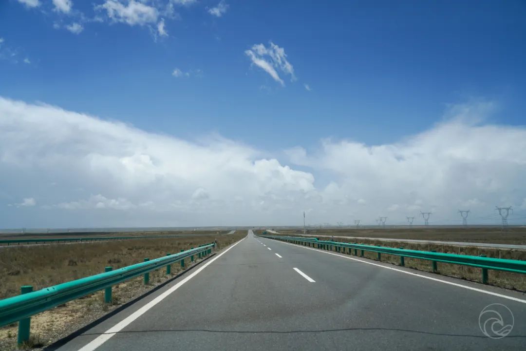
The Bitter Sea is the last point where the ancient Tang-Tibet road passed through Hainan Prefecture. More than a thousand years ago, Princess Wencheng's motorcade to Tibet passed here. She may have rested by the lake for a while and was attracted by the beautiful scenery~Gongyu Expressway and 214 National Highway are side by side. You can see the endless road at a glance. The clouds are so beautiful~
Keep on going~
Huashixia TownPassing by the first town at the source of the Yellow River - Huashixia Town, we have truly entered the GuoLuozang Autonomous Prefecture, and continue on the 214 National Highway all the way south.Maduo County
I forgot to climb a few more mountains later and was too lazy to take pictures. We arrived at Maduo County around 8pm. In fact, I have two ideas when passing through Maduo this time, one is to go to the "sister lakes at the source of the Yellow River" - Zhaling Lake and Eling Lake , and the other is to go to the source of the Yellow River Bull Head Monument. Unfortunately, the actual situation is not that easy. I consulted the innkeeper, who is an experienced outdoor off-roader. What I learned is that the road from Maduo to Niutoubei is currently closed. There is an option to take a detour from Qumalai. Enter in the direction or sneak in early in the morning, but the road conditions are not good, and there is snow, so it is not recommended to go now. After all, I only drive a one- or two-wheel drive urban SUV. The inn owner suggested that it would be safer to drive hardcore off-road, and suggested that I don’t go. Well, the current situation is really not stable, so give me a reason to come next time. I read the "Off-Road Road Book" "Exploring the Source of the Three Rivers" issue a long time ago, and I was thinking about when I could go to the source of the Mother River to have a look in person. Next time Let’s explore the Three Rivers Source when we are fully prepared, so the title of this article is a bit exaggerated haha, this time it can only be regarded as a first exploration.
King Gesar Theme Park
I couldn't go to Niutou Monument, so I stayed in Maduo for one night. The next day I decided to go to Yushu. When I checked out, the boss recommended a place for me to stop by and take a look👇
This is the King Gesar theme park. It is not open because of renovation. I took an aerial photo. The highest point is The sculpture of King Gesar sits on the top of the mountain with his head held high, his right foot on the ground, his left leg cross-legged on the bed, and a knife hidden at his waist, looking domineering and majestic!A circle of prayer wheels has been built around the park, and many elderly people have been praying around the park.I followed the huge prayer wheel and turned it around a few times to pray for blessings.
Stone monument at the source of the Yellow River in Sanjiangyuan National Park
sea of starsAbout ten kilometers from Maduo County, we arrive at Xingxinghai, which is right on the edge of National Highway 214. Friends who want to come here suggest taking the national highway. If you get on the Gongyu Expressway, you won’t be able to see the scenery up close. place. Xingxinghai It belongs to the water system at the source of the Yellow River. It is called Xingxinghai because it is full of wetlands and dotted seas. Unfortunately, the location I went to is not a good spot to take pictures of many seas.Most of the lake is still frozen, and the lake is full of broken ice washed up by the lake water. I tried aerial photography, but it didn't work. The location was still too low and I couldn't see the panoramic view of the sea of stars. My favorite angle, where the ice meets the lakeI drove the car directly to the lake. Since I couldn’t take any good pictures, I’ll take some for myself~ Not bad, hahaI also took two pictures of the small plane and found that the stickers on the fuselage were not removed. Haha, this is a young man’s first Hasselblad~After taking the photos, we continued to set off. After passing the Damaya Ridge, we reached a relatively high position. In front of us were dotted small lakes. Finally we knew why it was called the Sea of Stars.The scenery is nice, but the weather is really unpredictable. Sometimes it will be sunny, sometimes it will snow, and sometimes it will be windy. It can change at any time without any warning. .
We didn’t encounter many cars along the road. We basically stopped and walked all the way depending on our mood. It was really pleasant😌
Bayan Har PassPassing through Bayan Har Mountain Pass , the pass is covered with snow. Bayan Har Mountain Range is the watershed between Yellow River and Yangtze River source section. The border between Duoxian County and Yushu Tibetan Autonomous Prefecture is called Duoxian County. After passing here, you will enter Yushu Prefecture.The splendid temple buildings encountered on the roadThe sky turned dark and it snowed again. In addition to snow-capped mountains, lakes, and grasslands, you could also encounter many wild animals along the way. The most common ones were groups of Tibetan wild ass👇. I also saw Tibetan wild ass, wild fox, wolf and Woodchuck, but unfortunately not many of them were photographed. .
Tibetan wild ass
Yankou Mountain
Continuing over the mountains and ridges, after entering Yushu Prefecture, it is obvious that there are more temple buildings along the way.Tongtian River Bridge
I forgot how long I had been driving, and passed by Tongtian River Bridge. The water in the river was really yellow and fast.
Dangka Temple
On the road from Tongtian River to Yushu, I basically didn’t take any photos. I was really just driving. About ten kilometers away from Yushu city, I saw Dangka Temple in the distance, the front of the car We turned directly up the mountain, maybe there was some kind of grand ceremony, there were so many people, the parking lot was full of cars, we went up and walked around for a while and then came back down, and then there were a few old people who stopped and hitchhiked. I happened to be going to Yushu too, so I stopped by. I gave them a lift, but they couldn't understand Chinese at all, so it was a bit awkward not to be able to chat. I nodded wildly the whole time.
YushuJiegu Temple at the highest point of Yushu
First, we sent a few elderly people to the place and drove to the hotel. The construction in Yushu is really good. It feels more prosperous than Xining. I saw Dicos on the roadside. I haven't eaten there for a long time. Fried chicken legs, I'll get the two pistol legs later! ! Does anyone know what the building in the picture above is☝️
Today is Father's Day , This week, Zhou Dazhou had another day of work yesterday, and today he was completely paralyzed in bed😴. My mother probably thought I forgot, and sent me crazy hints on WeChat, which was very similar to last month's Mother's Day. , my dad sent me a Mother’s Day emoticon reminder early in the morning, how could I forget, it might just be a little late haha. I wish all the great fathers in the world a happy Father’s Day and good health! !