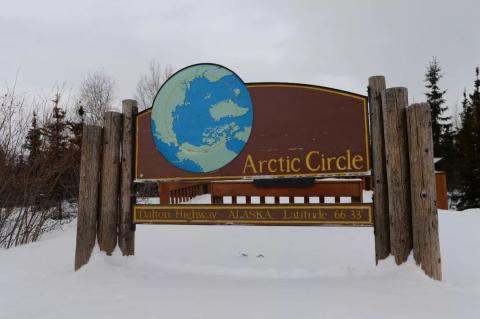
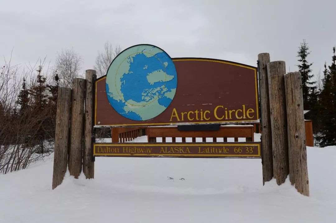


From Fairbanks, follow the Elliott Highway (Alaska Highway 2) 80 miles north to the starting point of the Dalton Highway. Continue 115 miles north to enter the Arctic Circle.
We set off at three o'clock in the morning, either with heavy snow in the sky or howling north wind. After many twists and turns, we finally arrived at the important goal of the trip - 66 degrees 33 minutes north latitude, the Arctic Circle Sign (Arctic Circle Sign) , this marks that we have entered the northernmost climate zone on earth: the northern boreal zone. We landed on the Antarctic continent 3 months ago. Unfortunately, we did not enter the Antarctic Circle at 66 degrees 33 minutes south latitude. This time we actually entered the Arctic Circle.
Just like our tourist attractions, the back of this signboard is covered with various stickers, with various signatures and messages written on it. Take a closer look at the Chinese elements on it, including unlocking, certificate processing, invoicing, and high-paying recruitment. China Style humor is everywhere.


The weather was really unfavorable, so we had to immerse ourselves in the journey. When crossing Denali, the highest peak in North America, we only stopped once at several viewing spots.
Denali Mountain, means "House of the Sun" in the local Indian language, with an altitude of 6194 meters, it is the highest peak in North America . The mountain is steep, The original name was Mount McKinley, named after William McKinley, the 25th President of the United States. A few years ago, during the Obama administration, the name was changed to Denali in order to show respect for the indigenous people.
The towns of coldfoot and wiseman:
This is the only stopping point on the entire stretch of road. It is used for refueling and accommodation. In fact, it is more like a highway rest area. Truck drivers coming and going come here to refuel, eat and stay.


There are 20 to 30 simple rooms available for living in the small camp area. The conditions are simple but expensive. A room costs more than 200 US dollars per night, which is equivalent to the living conditions at the Antarctic Great Wall Research Station. Although the room is small, you can take a hot shower. It is quite nice to be in the remote countryside with high mountains and rivers.


Wiseman is only 15 miles away from Coldfoot and is the last town on the Dalton Highway before it reaches the Arctic Ocean. During the gold rush a hundred years ago, this place was once a bustling settlement. With the decline of mining, just like our old industrial areas in the Northeast, the population was rapidly lost and the place gradually became deserted. According to the 2010 U.S. Census, there were still 20 long-term residents here, bustling with traffic and traffic. According to the 2016 census, only 12 residents were left behind.
It is located in the core zone of the aurora at 67 degrees north latitude. It is inaccessible and has no light pollution. If the weather is clear at night, this is the best viewing place in Alaska. Before our trip, we set our best hope of photographing the aurora here.

As the saying goes, the greater the hope, the greater the disappointment. From the time we checked into the room until late at night, the north wind was blowing and the snowflakes were flying. Although I was really tired after driving for a day, I didn't sleep much that night. I went out to take a look. , the heavy snow in the sky gradually turned into fine snow particles, and I was lucky enough to hope that the clouds would clear up and the aurora would appear. At around one o'clock at night, I drove to a nearby place to watch the sky at night. There was a thin band of light shaking in the sky in the distance. It should be the airstrip near Coldfoot. When I got on the road, the snow was still falling and there was no sign of improvement. In a wilderness place, turn off the car and get out of the car. Except for the slightest sound of falling snow, there is no sound at all around you, not even the chirping of insects, birds, or the friction between plants caused by the wind. It was eerily quiet. In such a vast area, there was no light as far as the eye could see, complete silence, and an unprecedented sense of tension. There was a sudden noise not far away, and I felt my hair standing on end and my breathing quickened. I quickly turned around and ran back to the car. I opened the car window and looked around, but I didn't see the ghostly eyes flashing in the dense forest. The world quickly returned to silence. I quickly took a picture of the road sign and slowly turned around and headed back to the camp. Maybe the sound of branches breaking under the weight of snow, or the movement of brown bears and elk, who knows.


After passing Coldfoot Camp and Wiseman, drive north for another 110 kilometers to Atigun Pass. Along the way, you will see a vast expanse of snow-capped mountains. This is recognized as the most dangerous section of the Dalton Highway because of its steep slope, slippery road, high altitude, prone to avalanches, and changeable weather. The wind speed is high, etc. Therefore, there is a warning sign before entering Atigun Pass to remind you that parking is strictly prohibited on this section of the road.
Before the pass, the landforms and ecosystems were mainly northern forest systems and transitional to the Arctic tundra. north The stronger the wind, the lower the temperature. There are fewer and fewer tall trees, and they are replaced by low shrubs. After passing this pass, you can no longer see trees. There is only moss on the ground and snow-capped mountains beside you. This is the real Arctic.


Arctic The Arctic tundra is a vast frozen swamp zone between the Arctic Ocean coast and the taiga forest, with a total area of 13 million square kilometers. Its biggest feature is a very thick layer of permafrost. Arctic Most of the tundra is in Arctic The climate in the circle is desert, with an annual rainfall of only 200 mm, and tall trees cannot grow. In winter, the entire tundra is covered with ice and snow, a desolate scene.
You can continue more than 100 miles north to the town of Death Horse, but you can't see the Arctic Ocean. The rest of the road is blocked by the oil company and no passage is allowed. There are 0 permanent residents there. If you must see the Arctic Ocean, you can join a tour group or rent a small plane in summer. There is no sea water visible on the Arctic Ocean coast during this season, only the frozen sea surface. All things considered, there was no scenery along the way, so we returned the same way.