The third issue of the Mountain and Wild Northern Xinjiang Line , the previous issue recorded the magnificent scenery and touching stories in Cocotuo Sea, Burqin and Hemu. We saw a paradise-like village and witnessed touching love.
The trip is still going on. Next, I will start from Kanas, pass by Urho, Kuitun, and arrive in Yining. Along the way, I will pass by the blue Kanas River, the towering fish viewing platform, the fantastic Yadan landform, and the clear Sailimu Lake, which is pure and connected to the sky, adds more moving colors to this journey.
Day 5
Visit Kanas
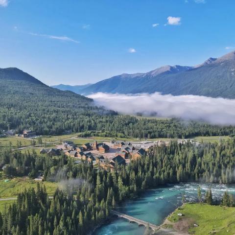
The beauty of Kanas has been introduced in the previous travelogue, especially the misty clouds in the morning make people feel like they are in a fairyland.
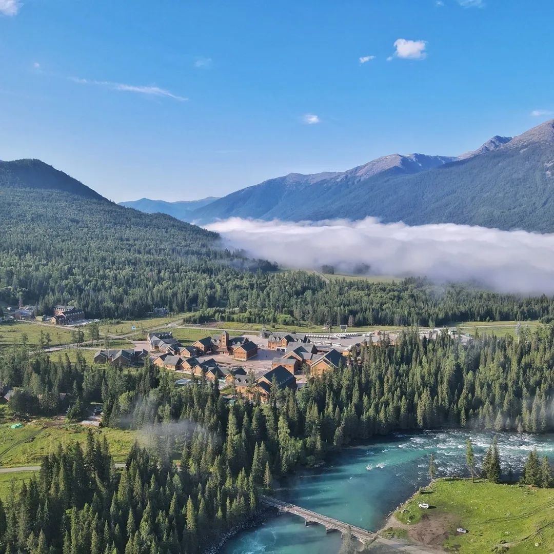
At night in Kanas, we all stayed in a local Tuva cabin.
These cabins have become the symbol of the Tuva people. Most of the cabins are buried in the soil to withstand the severe cold during the heavy snow closure period for nearly half a year. They are particularly primitive and simple, and have the traditional characteristics of the nomadic people. If Mr. Tao Yuanming is lucky enough to be here, I'm afraid he will write another "Peach Blossom Spring".

In fact, many small villages in Xinjiang are like this. They are located in picturesque places with distinct seasons, surrounded by layers of trees and clear streams. They are independent from the world and seem not to be disturbed by the outside world at all. Once you stay, you don't want to leave.

My last stop in Kanas was Fish Viewing Platform . From Kanas Scenic Area to Guanyutai, you need to buy an additional CMB ticket of 20 yuan, which is not included in the transportation in the scenic area. The bus walked through a winding mountain road and arrived at Guanyutai in about 40 minutes.
The Fish Viewing Platform is located on the top of Mount Halakat at an altitude of 2,030 meters. The vertical drop between it and the lake is more than 600 meters, making it ideal for overlooking the entire lake. A very special thing here is that visitors need to walk up 1060 steps to reach the pavilion at the top.

It takes about 40-60 minutes to climb the 1060 steps to the top, which is quite a challenge. It is recommended that friends with inconvenient legs and feet, or older people, reserve more time here.

When arriving at Guanyuting, if you reserve enough time, it is highly recommended that you walk down the mountain. Guanyuting has a dedicated walking path down the mountain, and the roadside is full of wild flowers in bloom.
Especially in the autumn of September, the entire scenic area is covered with mountains and forests, and the colors of the trees from the mountains to the bottom form a wonderful gradient, which is very spectacular.
The Kanas River has three famous bays: Shenxian Bay, Moon Bay, and Wolong Bay. The scenery is infinitely beautiful. The blue lake water ripples in the mountains, the layers of green trees make a brisk sound with the wind, and the white clouds float leisurely in the sky in the distance, making people look lost and forget the passage of time.

If time permits, it is recommended that friends reserve an extra day for Kanas. These three river bends have walking paths . When it’s cooler, take a leisurely walk along them. It is 13 kilometers long from Moon Bay to Wolong Bay. Facing the evening breeze and listening to the sound of the trickling river water can make people forget all their worries.
Day 6
Urho → Landform Feast

Driving mileage: 375 kilometers in total
Self-driving time: about 6 hours
Surprisingly, on the way to Urho, we were lucky enough to see the wonderful sight of a double rainbow.

In Urho, we went to the famous Devil City , which the Uighurs call "Shaytan Kersi". This is a typical Yadan landform area . Looking from a distance, the various strange and strange Yadan landscapes will make people marvel at the uncanny workmanship of nature.
If you walk into the Devil's City, you will be surrounded by many strange-shaped mounds, and there will be dry and cracked loess under your feet. There is no grass growing on the loess, and the surroundings will be completely silent. The name "Devil's City" is very appropriate.

Because it is located in a wind outlet, Devil City has constant strong winds all year round. The maximum wind force can reach level 10-12. The strong northwest wind gave the Devil City its "name" and gave it the "shape" of a devil, becoming grotesque.
Looking at the Windy City from a distance, it looks like a large castle in medieval Europe. There are many castles, large and small, scattered high and low. Over millions of years, due to wind and rain erosion, ravines of varying depths have been formed on the ground.The exposed stone layers have been carved into strange shapes by the strong wind.

In addition to the well-known Devil City Scenic Area, we also found that at the first intersection ahead of the scenic area, turn right and drive about 6km in the direction of the oil field. There is a Ye Yadan and the Devil The city's landscape is very similar, but more accessible. It only takes 5 minutes to walk to this Ye Yadan.

(Self-drawn Yeyadan route map for reference)
Next to Ye Yadan, there are two natural asphalt mines that are only mined in the world. Attractions are currently being built and can be viewed for free. I recommend everyone to visit them.

On the way from Devil City to Anjihai, we saw some melon farmers selling melons. Watermelons were only 0.6 yuan/kg and cantaloupes were 2.5 yuan/kg. It is recommended that you don’t miss them if you see them while driving.
Day 7
Karamay→Kuitun

Mileage traveled: 239 kilometers in total
Self-driving time: about 3 hours
Karamay means "black oil" in Uyghur, which is the essence of this city. On the way from Wuerhe to Anjihai, if you take the national highway, you will see vast oilfield mining sites as far as the eye can see. It is very spectacular.

Before coming to Xinjiang, I had heard about the Anjihai Grand Canyon from friends and guides, and the videos I saw were very shocking. Therefore, the Grand Canyon is one of the key points of this trip.
However, due to various reasons, officials currently say that the geological collapse is rapid and dangerous, and tourists are not allowed to approach. In fact, they are probably preparing to build a scenic spot. After all, the place needs development, so it is closed, but there are still access ways.
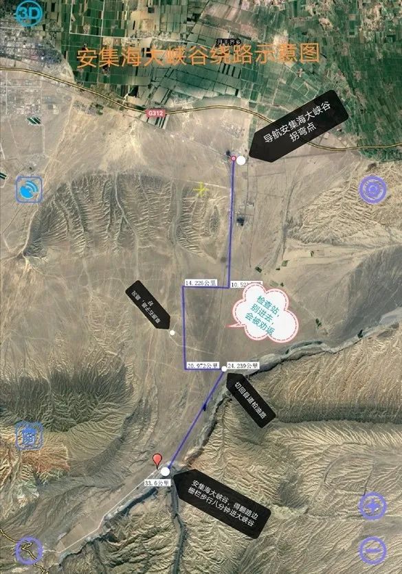
(A schematic diagram of the Anjihai Grand Canyon detour drawn by myself)
Navigate to the Anjihai Scenic Area on the map. Turn from National Highway 312 to Buhong Section County Road 829. When you drive about 4KM further, there will be a checkpoint. This temporary checkpoint is to prevent tourists from going to the Anjihai Grand Canyon. But it’s actually still 10KM away from the Grand Canyon.
There is a simple parking lot on the right 800 meters away from the checkpoint. There is a two-lane dirt road going in along the simple parking lot. According to visual inspection, there is a construction site inside. After walking about 3km on the dirt road, you will see the grassland on the left. There are traces of roads where many cars have passed. Follow the traces and drive in until you have probably bypassed the checkpoint. Then you can find a way to re-enter the county road, and drive 7KM further.
You can find the location of Anjihai Grand Canyon on the navigation. There is an obvious yurt. You can walk into the Anjihai Grand Canyon from the yurt .
There is one thing to note here. The road in the grassland is very straight and most of the road is very flat. Many people have never driven on this road. They drive very wildly when they first get on this road. However, there are also some big potholes. If you drive too fast, you will enter the big potholes. , you know, the lesson of bumper blood.


Anjihai Grand Canyon is a name widely spread on the Internet. It originates from the Anjihai River in the canyon. However, because there is a Hongshan coal mine here, the locals also call it Hongshan Grand Canyon.
In addition, she actually has a name, called Kulkarawusu Grand Canyon. This is the place where two canyons meet, and it is also the best place to view Anjihai Grand Canyon!
It is recommended to arrive around 9:00 pm . At that time, the sun is shining on the canyon landscape, with darkness and light. The illuminated canyon is lush and green, and the scenery is moving.

The cliffs of the Grand Canyon are very steep, so we remind everyone to be careful when taking photos.

There is a large piece of red sandstone in the northeast section of the Anjihai Canyon, which is also the most beautiful place!

Day 8
Kuitun → Sailimu Lake

Mileage traveled: 239 kilometers in total
Self-driving time: about 3 hours
At about four or five o'clock in the afternoon, we arrived at Sailimu Lake Scenic Area . Sailimu Lake is the mountain lake with the highest altitude and largest area in Xinjiang. Known as "Jinghai" in ancient times, it is also known as Santai Haizi. The lake is crystal clear with a transparency of 12 meters.
It is located in the Bortala Mongolian Autonomous Prefecture, but because it is connected to the Guozigou Bridge in the Ili Kazakh Autonomous Prefecture, many people think that Sailim belongs to the Ili Prefecture. But if you dare to say this in front of the people of Bole, you will definitely be punished. Very miserable.
Because the warm and moist airflow from the Atlantic Ocean can only reach here as far east as possible, and is eventually blocked by the tall Tianshan Mountains to form rainfall and gather into a lake, so Sailimu Lake is also known as "The Last Tear of the Atlantic Ocean" .

Tickets here are 35 yuan per person, 375 yuan for a 5-seater car, 525 yuan for a 7-seater car, and 75 yuan for a shuttle bus. Therefore, it is recommended that if there are 4-5 people traveling together, it is better to drive in because Sailimu Lake is very large and it is very convenient to drive and stop at any time.
The recommended play time is 2-3 hours, but the consumption in the scenic area is high, so it is not recommended to live in the scenic area. There is a RV camping site in the scenic area, which costs 500 to 600 RMB per night.

Sailimu Lake is an alpine lake with the highest altitude, largest area and charming scenery in Xinjiang. It includes scenic tours around the lake, grassland nomadic style and other scenic areas.
The suggestion here is that if the weather is normal, you can choose not to enter the scenic spot for viewing, becauseyou can see the scenery of Sailimu Lake along the highway from Sailimu Lake to Yining.

On the way from Sailimu Lake to Yining, you will pass the spectacular Guozigou Bridge when you drive about 30 kilometers. The driving route is 4.4 kilometers long and the bridge is 700 meters long.
The bridge deck is 200 meters above the valley floor. The main bridge is made entirely of steel truss structures, using 17,000 tons of domestic special bridge steel and high-strength bolts for connection. The bridge is the first cable-stayed bridge on the autonomous region's highways and is also The first double-tower, double-cable-plane steel truss cable-stayed bridge in China.

Friends with drones will pass by an office building compound under construction when they are approaching Guozigou Bridge. This is the best place to view it. You can see the whole picture of Guozigou Bridge and the overall impression. Best, but generally not allowed to tourists.
If you can't get in, you need to park your car nearby and let the drone go out to take pictures. However, it is not recommended that you stop in the emergency lane to take photos. It will be more dangerous and the viewing angle is average.
After taking pictures of Guozigou Bridge, we continued to set off to Yining with great expectations. On the way to Yining, we will pass Guozigou Checkpoint , which is currently the strictest checkpoint in Xinjiang . We spent 1.5 hours here.

TIPS
Check steps:
First, tourists will be asked to scan the code to check various itinerary information, and then the staff will register the information of the people in the car.
After entering the checkpoint, we will register again. If we are tourists from outside Xinjiang, the staff will also take away our driving license and ID card to check whether we have entry and exit records in the last 6 months , or in Residence history of Hubei/Tianjin/Hebei/Shanghai/Beijing/the three eastern provinces , if so, cannot pass the checkpoint.
It is recommended that you reserve 1.5-2.5 hours to avoid disrupting your travel plan. Since many tourists will wait here for a long time, the staff will give you watermelon and cantaloupe to eat. You can feel the enthusiasm and kindness of the people of Xinjiang. .
Ad's story continues.