Warming China, turning northwest into Jiangnan?

Since the Tang Dynasty
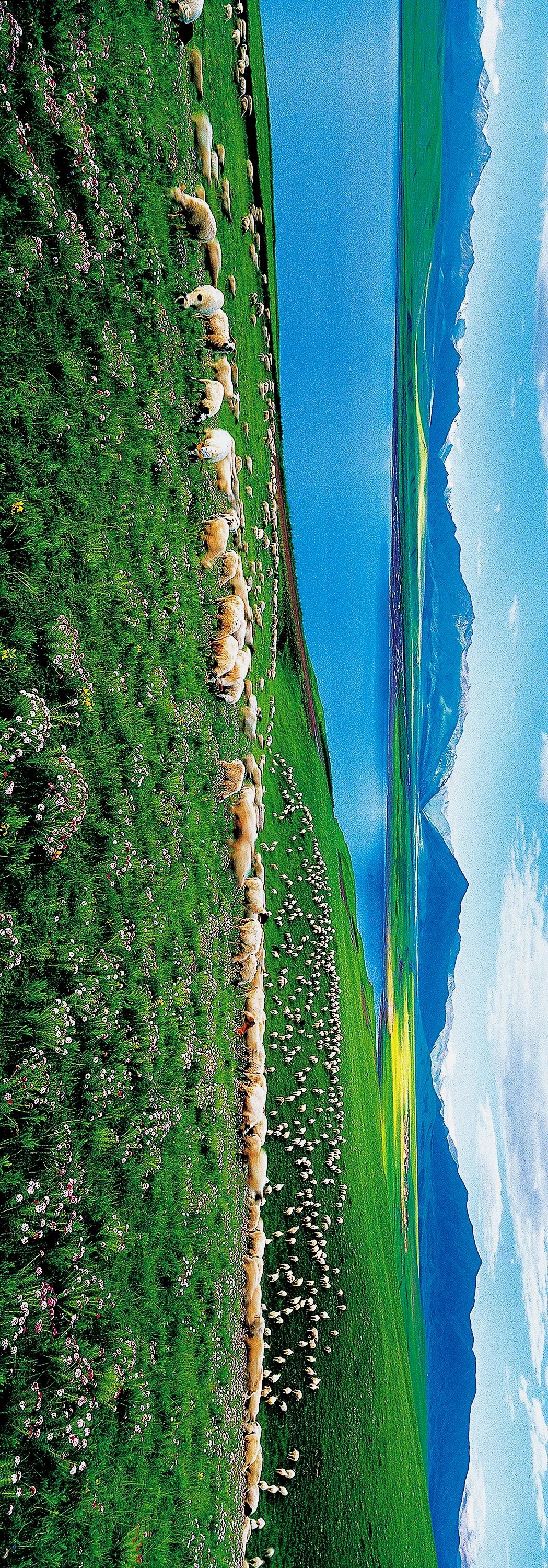
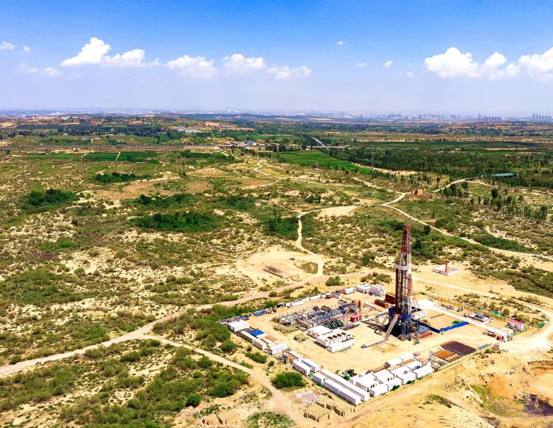
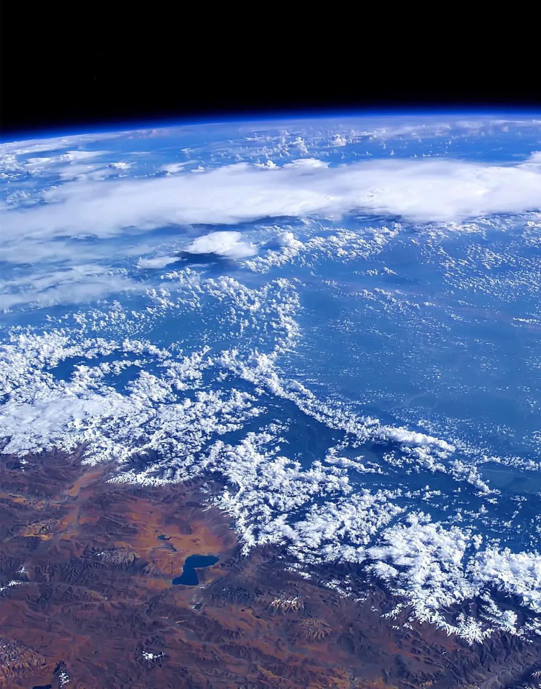
Northwest China, once lush with water and grass
The river is shrinking day by day
Guangze returns to quicksand
The only remaining ruins of the ancient city of Loulan
vaguely telling
silk road
The lushness and prosperity of those days
Time goes by
Changes in the sea
Today’s Great Northwest
Furukawa restarts
Great Lakes Regeneration
The desert becomes an oasis
The northwest becomes Jiangnan
Is this a flash in the pan?
still
The spring breeze comes to Yumen Pass again
丨
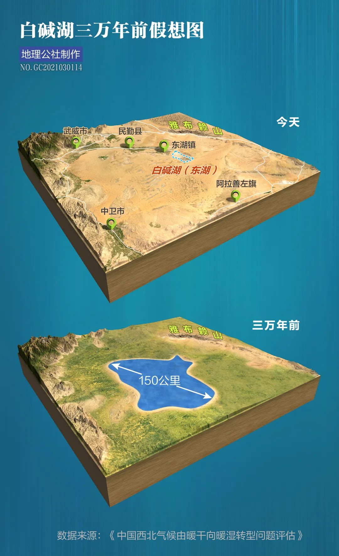
1 Great Lake Reborn
"The solitary smoke is straight in the desert, and the sun sets over the long river."
A frontier fortress poem with powerful artistic conception by Wang Wei
Not only did it amaze the entire Tang Dynasty,
It also allows future generations to have a glimpse of
At that time, there was abundant water in the northwest frontier
actually
The Silk Road from Chang'an
Crossing the Hexi Corridor
It’s not like the sky full of yellow sand in literary works
A dangerous road
On the contrary, it is full of oases
Prosperity all the way
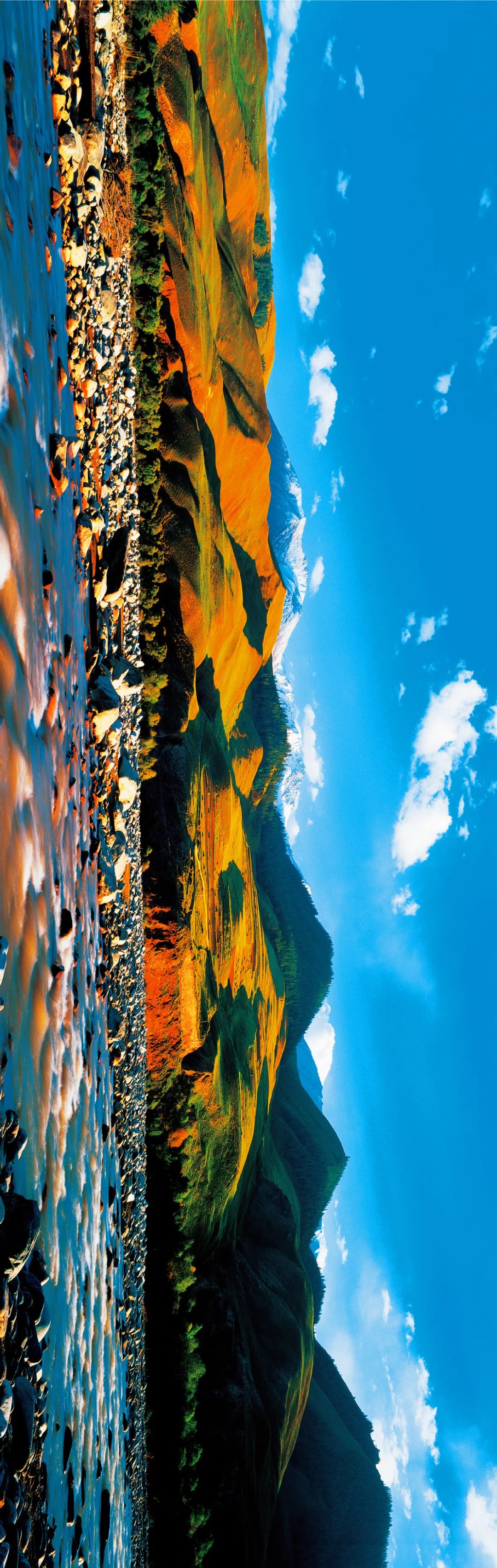
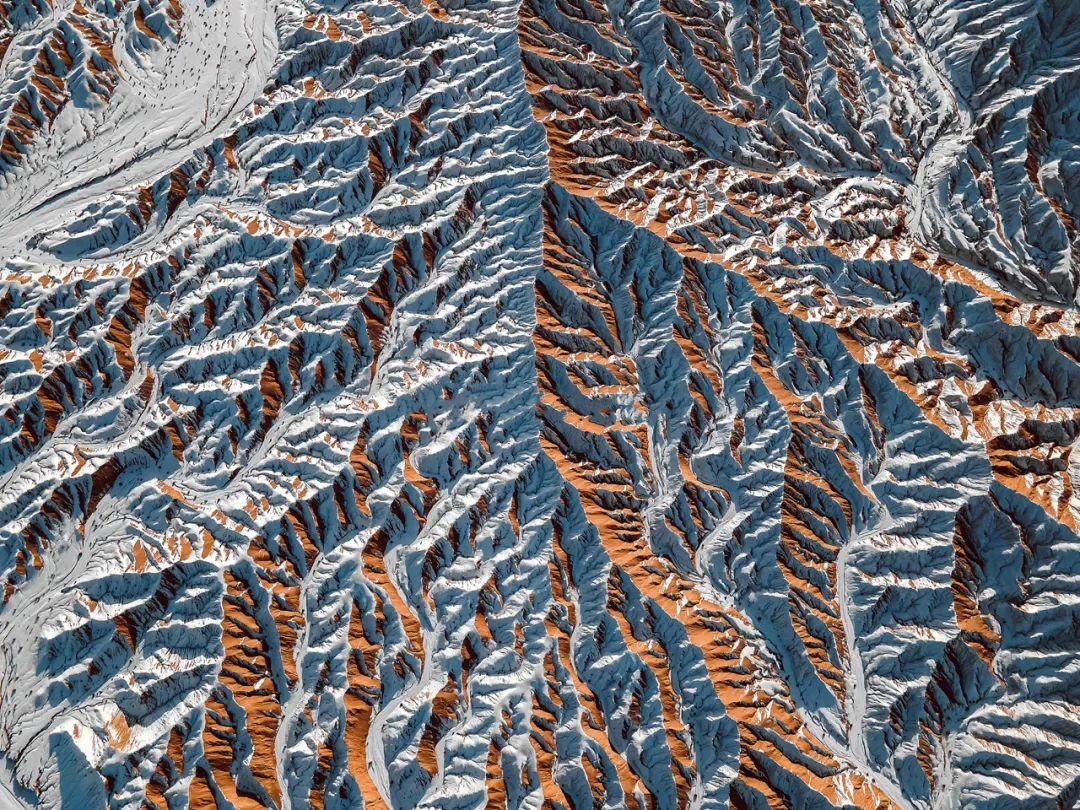
The pure white snow peaks, fiery red colorful hills , the lush green river valleys, Zhangye City in the middle of the Hexi Corridor, the charm of the Silk Road heritage is fully displayed. Photography|Lee Yongjun
Late Tang Dynasty
The climate gradually changes from warm to cold
Northwest Territories Extremely Sensitive to Climate Change
Since then
Rivers shrink
The oasis disappears
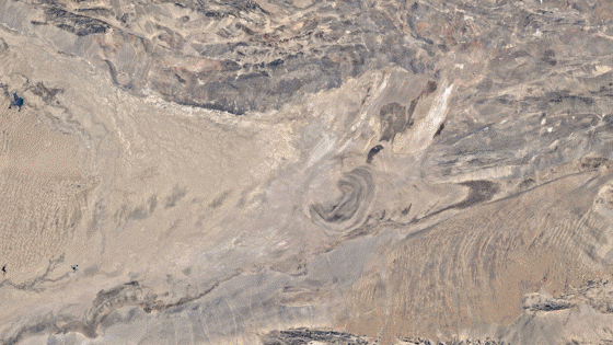
The once vast Lop Nur
Gradually disappearing in the long sand
As historians and geographers agree
Climate and the Process of Human Civilization
have a very important connection
Thousands of years to come
The prosperity of the Silk Road
Falling into silence
(Please view horizontally)
late 20th century
turn of the century
A series of changes are coming quietly
The entire northwest
The river that has passed for thousands of years has regained its youth
Ancient lake restarts
Bibo Yingying
Rongguang of Han and Tang Dynasties
Seems to be returning to the Hexi Corridor
(Please view horizontally)
For thousands of years
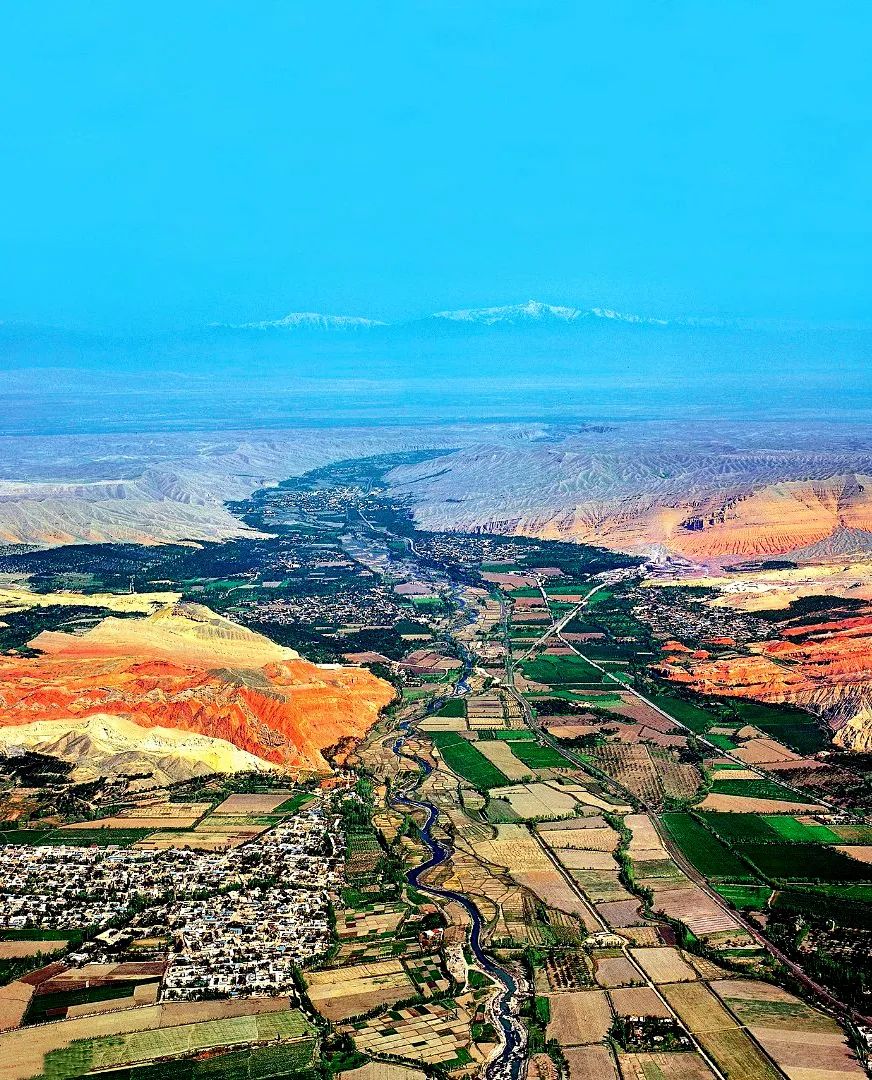
Hexi Corridor
Not only the dynasty stationed troops and guarded the border
forward position
It is also the golden channel of the Silk Road
it depends on
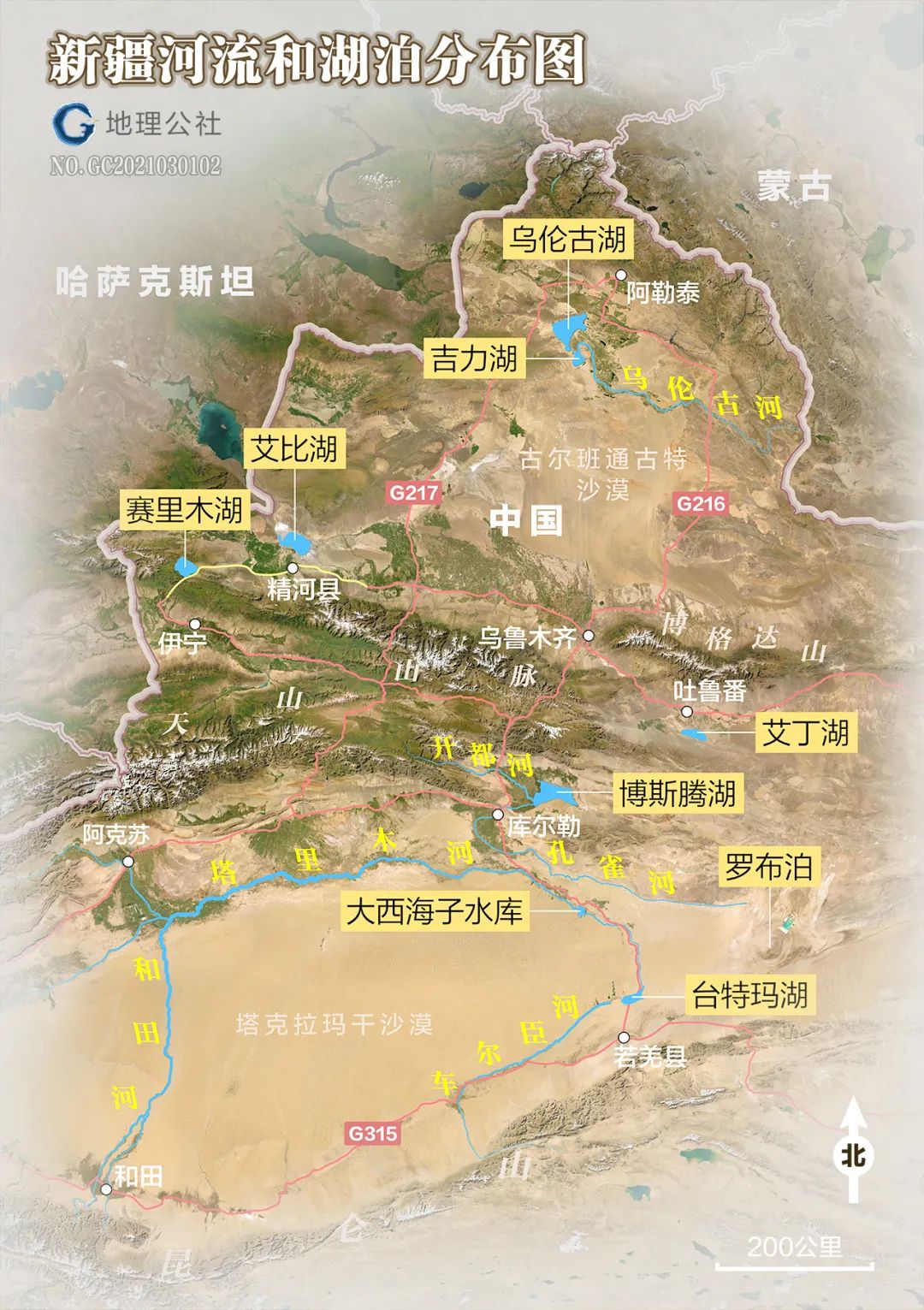
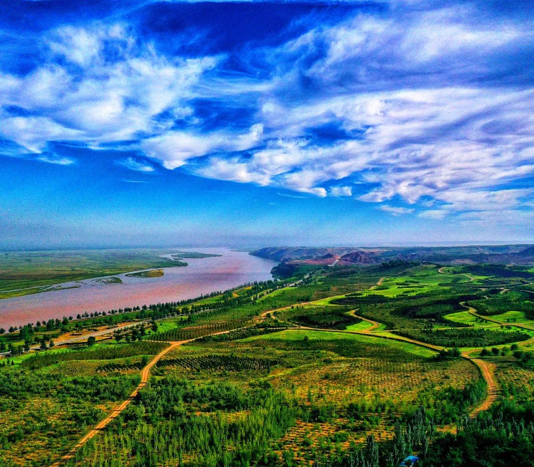
It is the nourishment of the three inland rivers Shule River, Shiyang River and Heihe River.
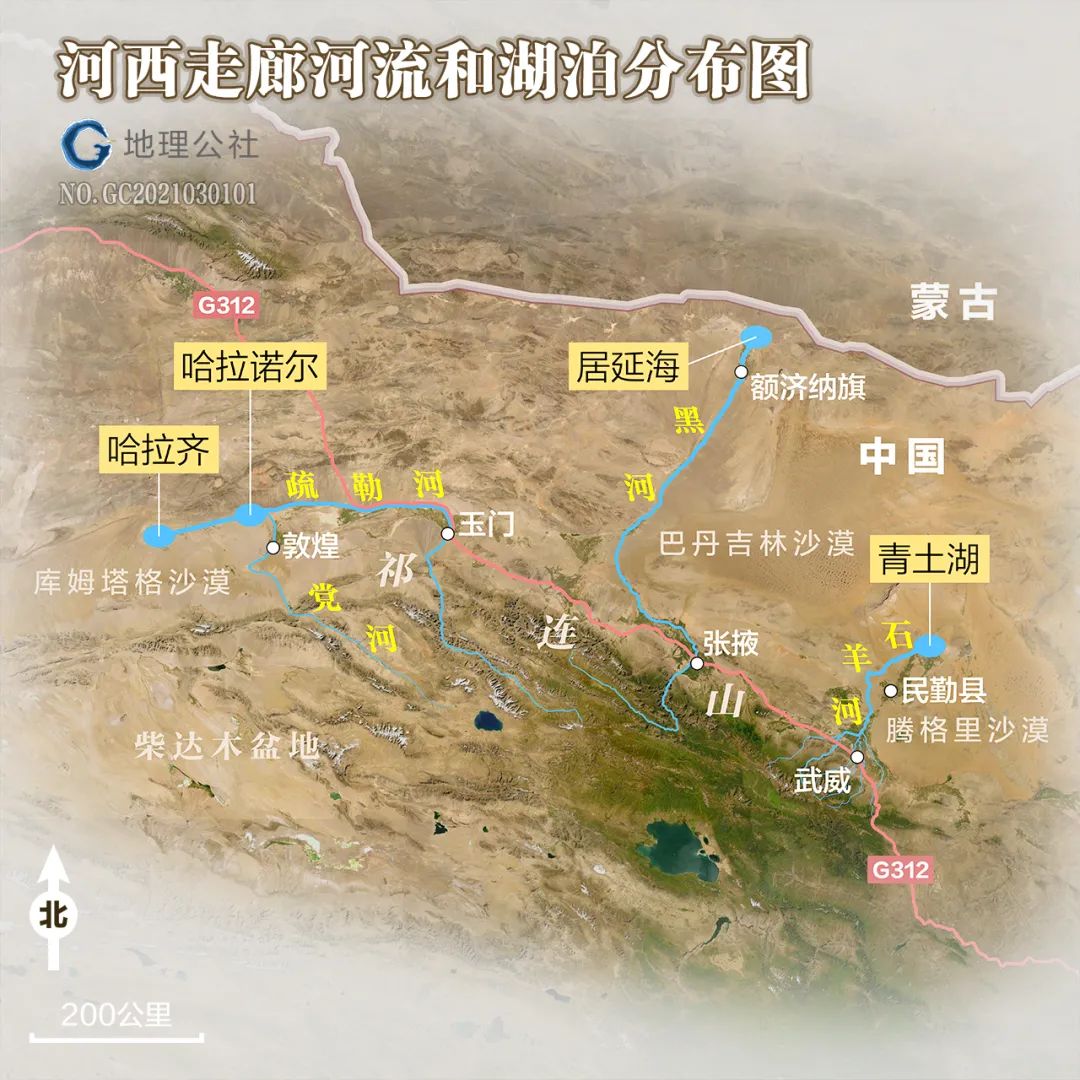
Cartography丨Geography Commune丨Du Zhuoyi
The three major inland rivers in the Hexi Corridor originate from the Qilian Mountains, and Weulu Lake is located in the desert.
Shule River
The ancient name "Ji Duanshui"
Among the three major inland rivers in the Hexi Corridor
Ranked second
The river lake formed by the intersection of Shule River and Dang River
Haranor
The largest area ever reached 70 square kilometers.
Equivalent to 12 West Lakes
Since the Qing Dynasty
The water surface begins to shrink
And in the 1950s and 1960s
completely dry
However
Fall 2016
The surface of Haranor reappears
Spring 2017
The flooded area has reached 24 square kilometers
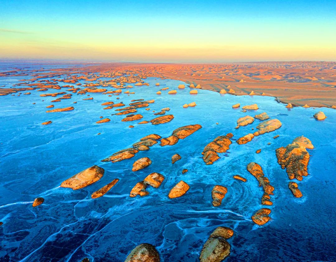
Haranor, which has been dry for more than 60 years
The blue waves are actually rippling
Recreate the beautiful scenery of Gobi sea view
omnipotent nature
As if to prove that all this is not accidental
Mid-October 2019
Overflowing Lake Haranor
all the way west
Along the old path of Shule River, which has been dry for nearly 300 years
A long drive of 140 kilometers
flows into Weilu Lake Haraqi further west.
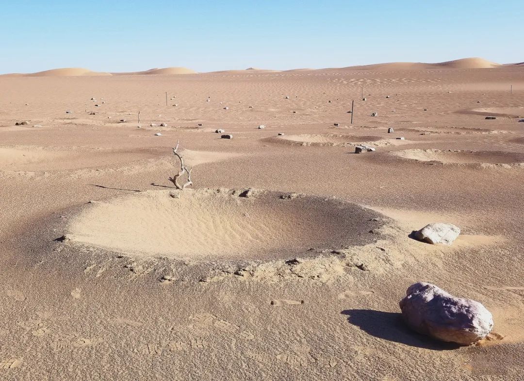
Among the dunes of Kumtag
Forming pieces of dreamlike small lakes
sparkling waves
The grass grows and the orioles fly
Become a paradise for wild camels and Przewalski's horses
Dunhuang citizens accustomed to seeing the yellow sand of the Gobi Desert
rush to go
Get a glimpse of the wonders of the inland sea view

Shiyang River
Ancient name Gushui
Ranked the third largest river in the Hexi Corridor
After winding for 250 kilometers
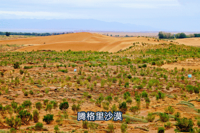
Dissipate in the Tengger Desert at Minqin Oasis
Qingtu Lake is the tail lake of Shiyang River
During the Western Han Dynasty, it was called Zunye Ze
Quanta 4000 square kilometers
The same area as Qinghai Lake
After completely drying up in 1959
Quicksand rages
Forming a 13-kilometer long wind and sand line
Minqin Oasis is in danger
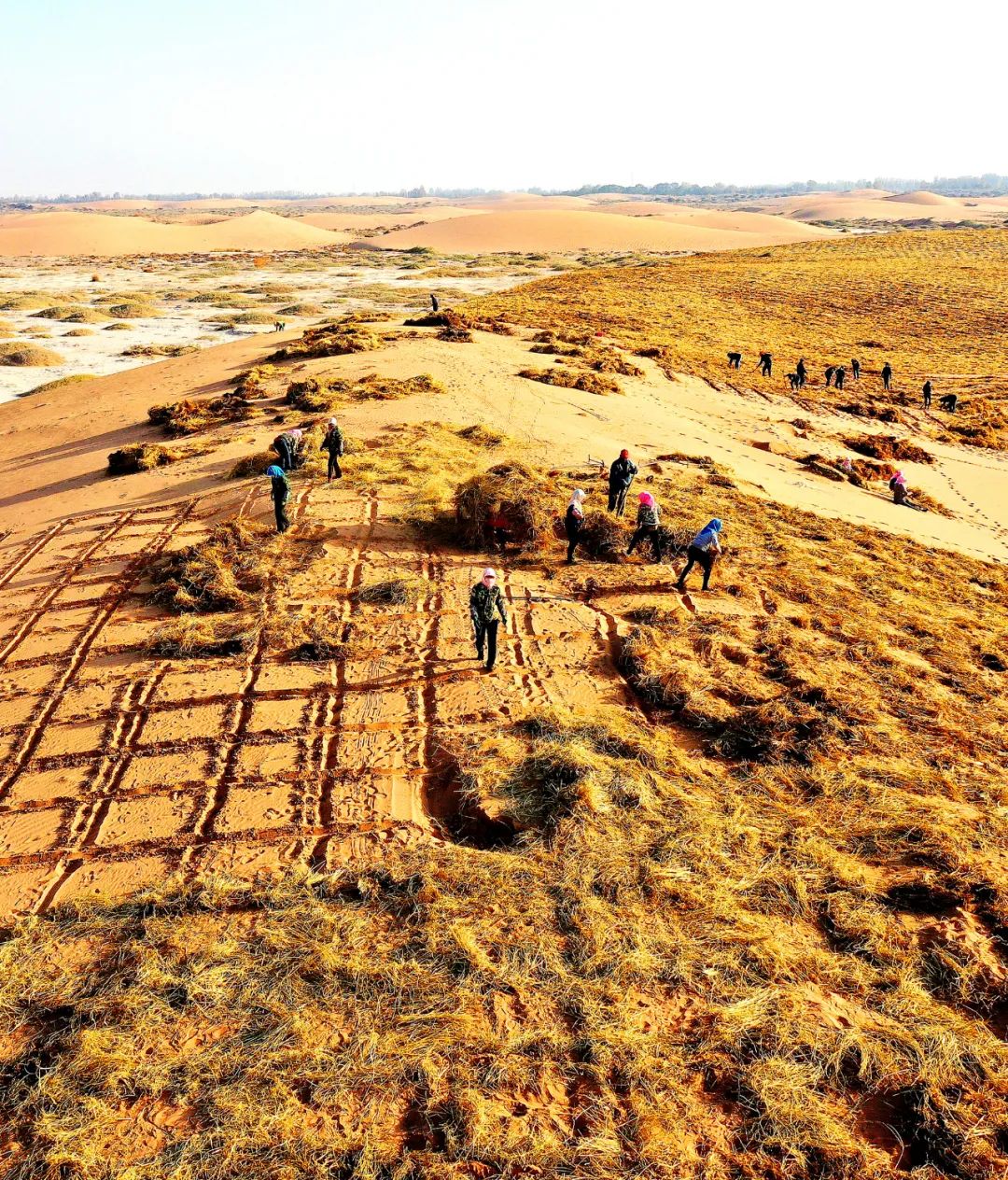
Villagers in Sifang Duntan, Minqin, use grass squares to block quicksand and protect their homes. Photo courtesy | Qingsuo Charity
In the autumn of 2010
Qingtu Lake has been dry for 51 years
a lake
Appear quietly
2020
The water surface expanded to 26.7 square kilometers
Forming 106 square kilometers of dry area wetland
completely broken
It is surrounded by the two deserts of Badain Jaran and Tengger Desert
Minqin Oasis
After all the vicissitudes of life
Survive again from desperate situation
Among the three major inland rivers in the Hexi Corridor
Heihe ranks first
A river of snow flows northward
Finally settled in Yanhai
It is translated as weak water flow sand in "Shui Jing Zhu"
It was called Juyanze in ancient times
According to legend, Lao Tzu attained enlightenment and became an immortal here.
Queen Mother of the West entertained King Mu of Zhou here
Historical records
Huo Qubing, God of War
From here, we attacked the Huns four times.
Wang Wei's Poems
"Outside the city of Juyan, the genius is hunted, and the white grass is burning in the mountains."
Such a place where people gather together
Juyanze covers an area of 3,000 square kilometers
It was actually covered up by quicksand in 1961
Beginning of 2000
The ancient river channel of Heihe River that has not received water for more than 600 years
The river surges again
Haohao Tangtang
A thousand miles away
Ju Yanze, who has gone through many vicissitudes of life
Nirvana rebirth
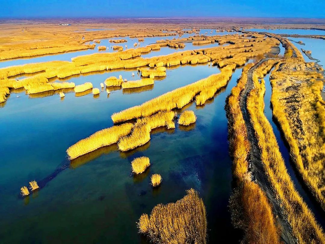
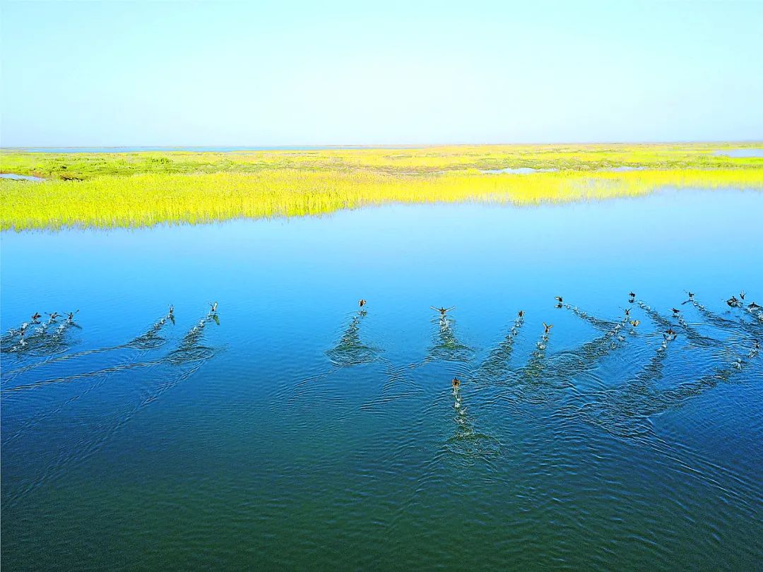
 In 2020, Juyanhai expanded to 66.3 square kilometers, equivalent to 12 West Lakes, and the largest in a century. Photography | Wang Meng
In the arid and semi-arid regions of the Northwest
The resurrection of a series of rivers and lakes
does not exist in isolation
Not only the rivers in Gansu’s Hexi Corridor
Resurrected one after another
On the broader land of Xinjiang
lakes
Has also quietly regained its youth
 Cartography丨Geography Commune丨Du Zhuoyi
Lake Aibi is located on the southwest edge of the Junggar Basin
It is the largest saltwater lake in Xinjiang
year 1987
Shrunk to 499 square kilometers
In recent years, the amount of water entering the lake has increased significantly
2020
The water area has expanded to 805 square kilometers
Increased the area of 60 West Lakes
Lake Aibi Duck Bay. Abundant water supply regenerates the surrounding wetlands. Photography | Wang Meng
Tatma Lake
Located on the eastern edge of the Taklimakan Desert
It is the tail end of the Tarim River and the Chelchen River.
mid-century
300 kilometers downstream of the Tarim River cut off
Lake Tatma has completely dried up
disappeared along with
And Lop Nur
Since 2000
Daxihaizi Reservoir
Open the gate and release water 21 times
8.43 billion cubic meters of clean water flowed into the old path of the Tarim River
Populus euphratica is dense again
Tamarisk trees are everywhere again
Still water flows deep again
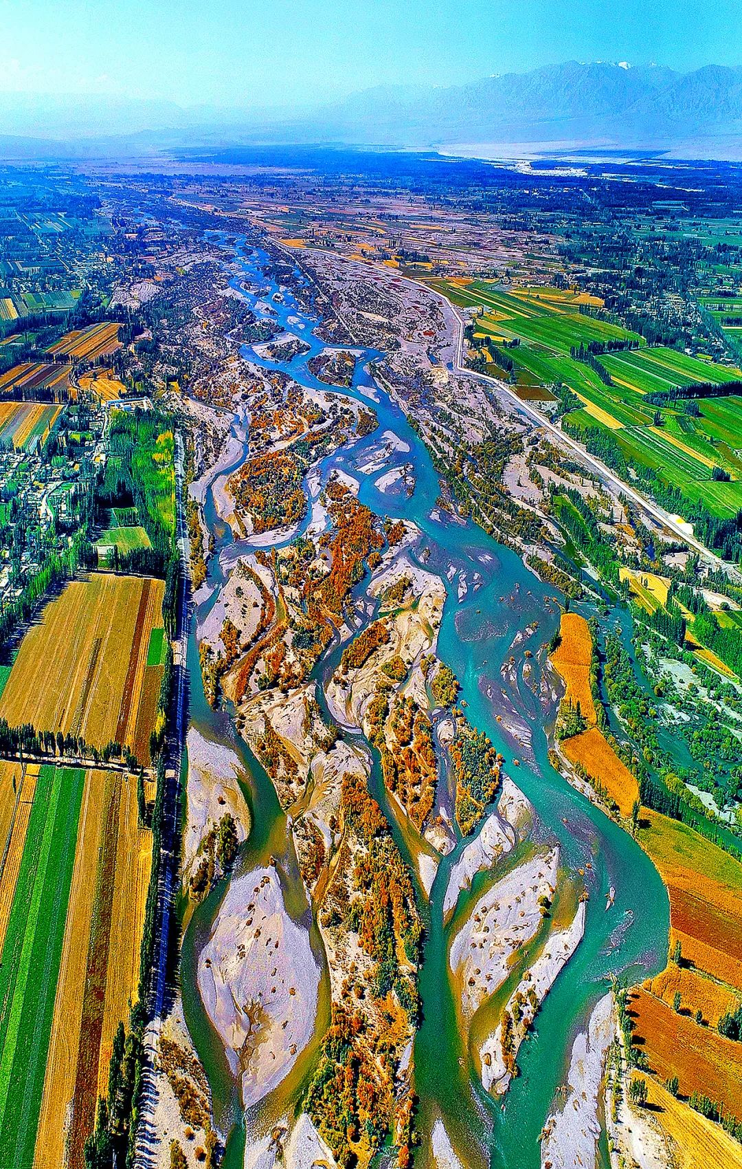
Taitma Lake returns
Just like a boy
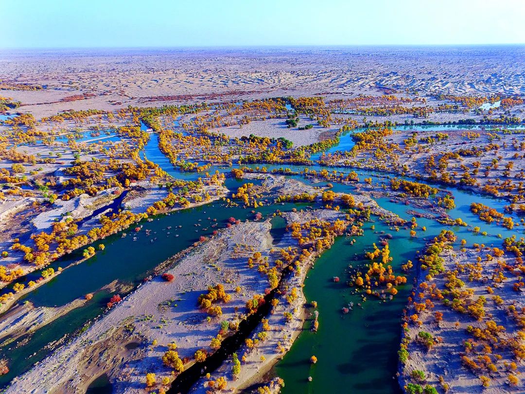
National Highway 218 crosses Taitma Lake
Driving on it
like a water highway
Manjiang Bitou
Overflowing gold
No one can imagine
once dried up lake
unexpectedly ushered in
"The falling clouds and the solitary owl fly together, and the autumn water becomes the same color as the sky."
in more arid
Qinghai Qaidam Basin
remote sensing monitoring data display
Since 2009
most lakes
The area shows a fluctuating increasing trend
Xiao Qaidan Lake in the central and northern Qaidam Basin
1976
The area is only 40.4 square kilometers
Now it has grown to 103.94 square kilometers
Equivalent to 2.5 times the original
In the Taijiner Lake area in the southwest of the Qaidam Basin
Flooding
Earth-shaking changes are taking place
 Cartography丨Geography Commune丨Du Zhuoyi
Narengrad River
The largest river in Qaidam Basin
Originating from Snow Lotus Mountain in Kunlun Mountains
Finally merged into Taiji Nair Lake area
July 2010
A huge flood occurred in the Narengrad River
Salt mining companies in East and West Taijinell Lakes
Disaster relief
Build dozens of kilometers of embankments separately
Block access to the lake
1.1 billion cubic meters of flood found another way
The area of Yahu Lake quickly expanded to 300 square kilometers.
Forming a rare water Yadan in the world
Due to the obstruction of the long embankment
Dongtai Jinair Lake lost river water replenishment
water level dropped
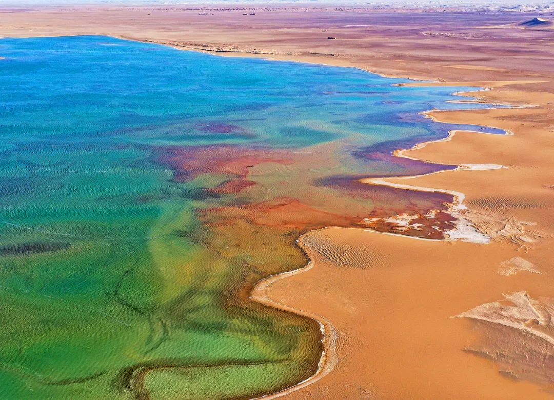
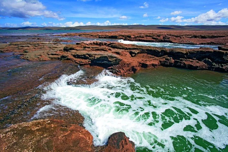
The sediment gradually settles
Seems particularly clear
This ancient magnesium sulfate subtype salt lake
Under the sunshine of the plateau
Showing different shades of blue
Independence for thousands of years
Finally broke out of the cocoon and became a butterfly
transformed into a fairy
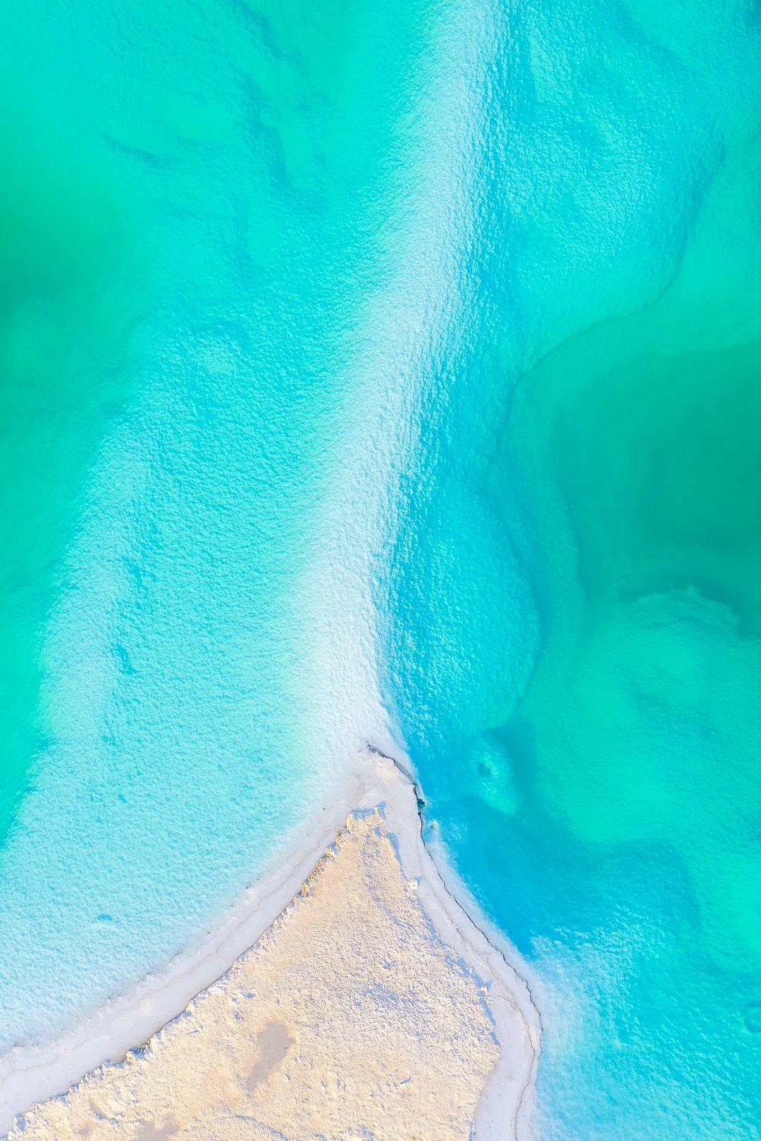
This touch of Tiffany blue from the Northwest
Not inferior to the Maldives at all
Resurrection of Dongtai Jinair Lake
After becoming Chaka Salt Lake
Another new internet celebrity check-in place
Countless people come here to admire it
Where water and sky meet
Step into the white causeway
It seems like I've arrived
dream world

just a few decades
From the Hexi Corridor to the Taklimakan Desert
From Junggar Basin to Qaidam Gobi
Water levels of inland lakes throughout the Northwest
Showing an overall upward trend
Changes in inland lakes
A mirror of climate change
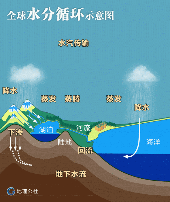
In the arid and semi-arid regions of the northwest
Expansion of lake area
Mainly due to increased river runoff
River runoff comes from precipitation and glacier meltwater
Expansion of the Northwest Lake Group
It means changing from warm and dry to warm and wet
A climate change
is happening quietly
丨
2 As it gets warmer and wetter, will the northwest become Jiangnan?
Academician Shi Yafeng
China’s “Father of Glaciers”
Deep cultivation of western glaciers for many years
Back in the 1980s
He paid attention to the changes in the increase in precipitation in the northwest
Acutely aware of the climate transition in the Northwest
and become the key to the great changes of this century
discoverer
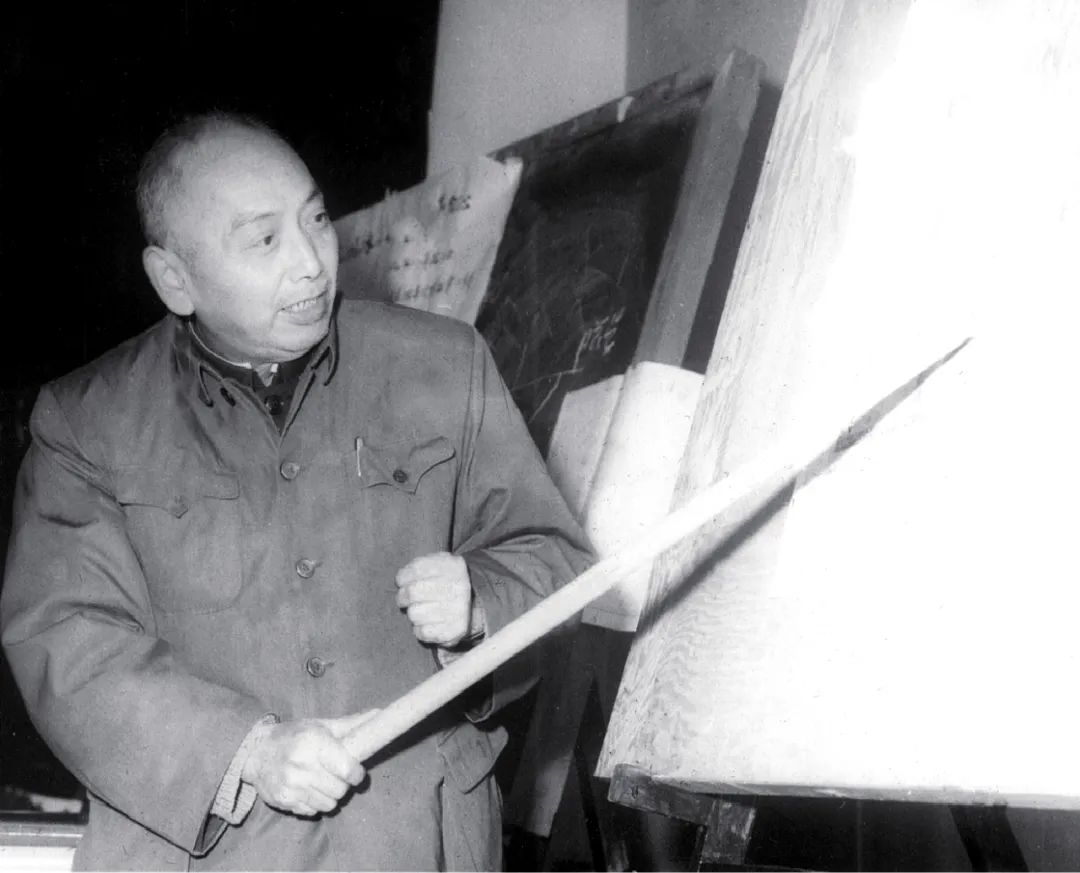
Starting in 1957, Shi Yafeng(1919-2011) traveled all over the snow-capped mountains and glaciers in the west, becoming the pioneer and founder of modern glacier science in China. Photo courtesy | Shen Yongping
1987
History should remember this special year
It was in this year
The climate of the northwest and western regions
A sudden transition to warm and humid conditions occurs
The main supply source of Bosten Lake in the central Tianshan Mountains is the Kaidu River.
Annual runoff at Dashankou Station
From 2.47 billion cubic meters in 1986
increased to 4.97 billion cubic meters in 2000
Fully doubled
The rapid annual increase in the diameter of the Kaidu River It can directly indicate the characteristics of a significant increase in precipitation and glacier meltwater in the Tianshan Mountains. Photo by Wang Hanbing
2001
Shi Yafeng learned from Professor Hu Ruji’s paper
Learned that Bosten Lake has been recorded since 1955
Water levels have been on a downward trend
The area has also been reduced by 13%
But starting in 1987
The lake’s water level is rising at an unprecedented rate
to 2001
Bosten Lake water level
has returned to the level of the 1956 wet season.
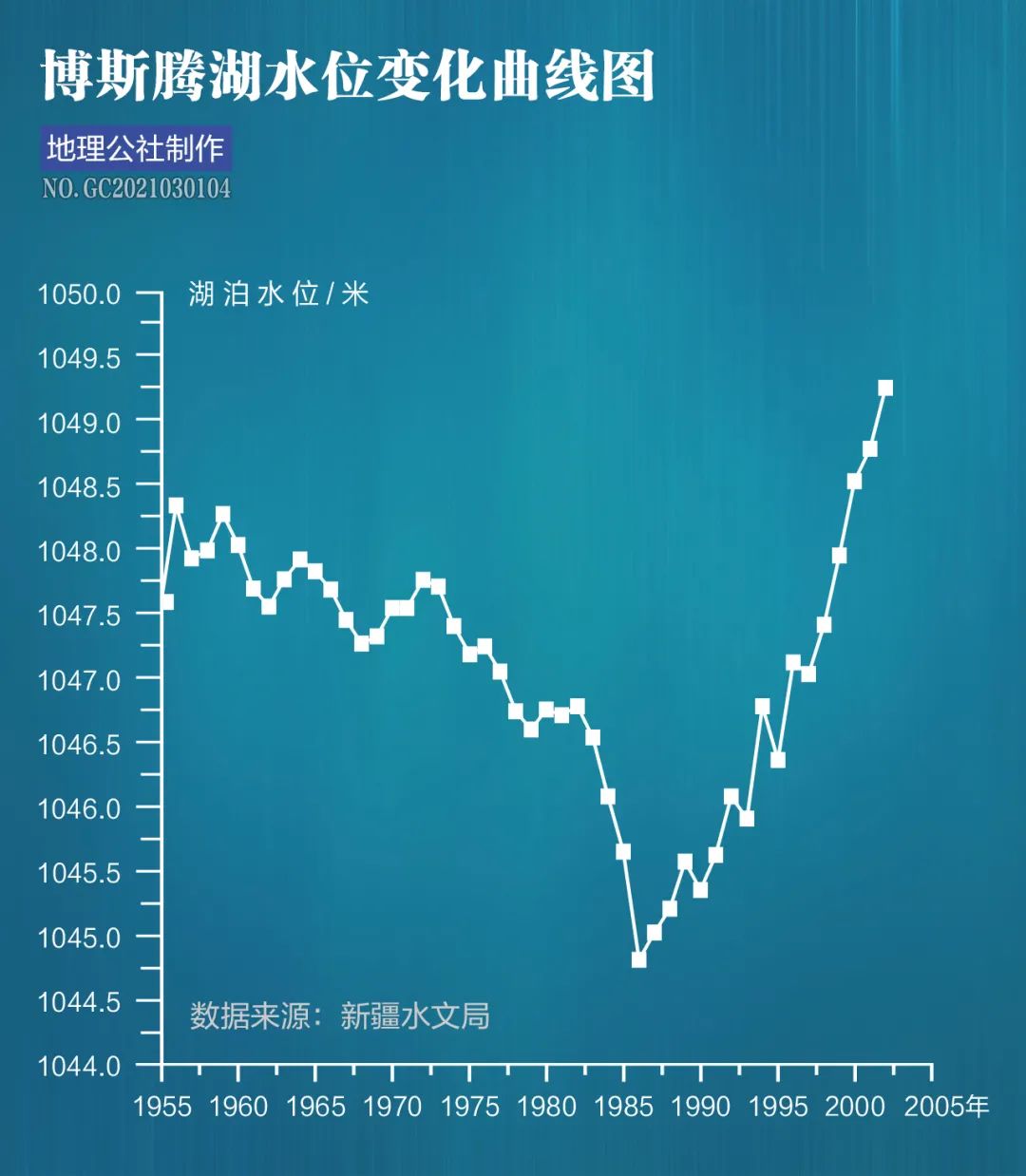
Precipitation and runoff of Bosten Lake
significantly exceeded
Sum of evaporation, output and irrigation water
The lake area has not seen any decline for 15 consecutive years
Water levels rise rapidly
Indicates the occurrence of hydrological environment in mountainous areas
major changes
Shi Yafeng inferred from this
Northwest climate
There are clear signs of a transition to warm and humid conditions
June 2002
Shi Yafeng led the team to Xinjiang
In-depth research
The outline of warm and humidification in northwest China is gradually becoming clearer
September 2002
At the initiative of Shi Yafeng
Institute of Cold and Arid Regions Environment and Engineering, Chinese Academy of Sciences
Joint China Meteorological Administration Climate Center
Xinjiang Autonomous Region Hydrology and Water Resources Bureau and other 10 units
Seminar held in Lanzhou
Scientists basically agree
Hypothesis on the climate transition from warm-dry to warm-wet in northwest China
and its impact on prospects
Make assessments and estimates
Cartography丨Geography Commune丨Du Zhuoyi
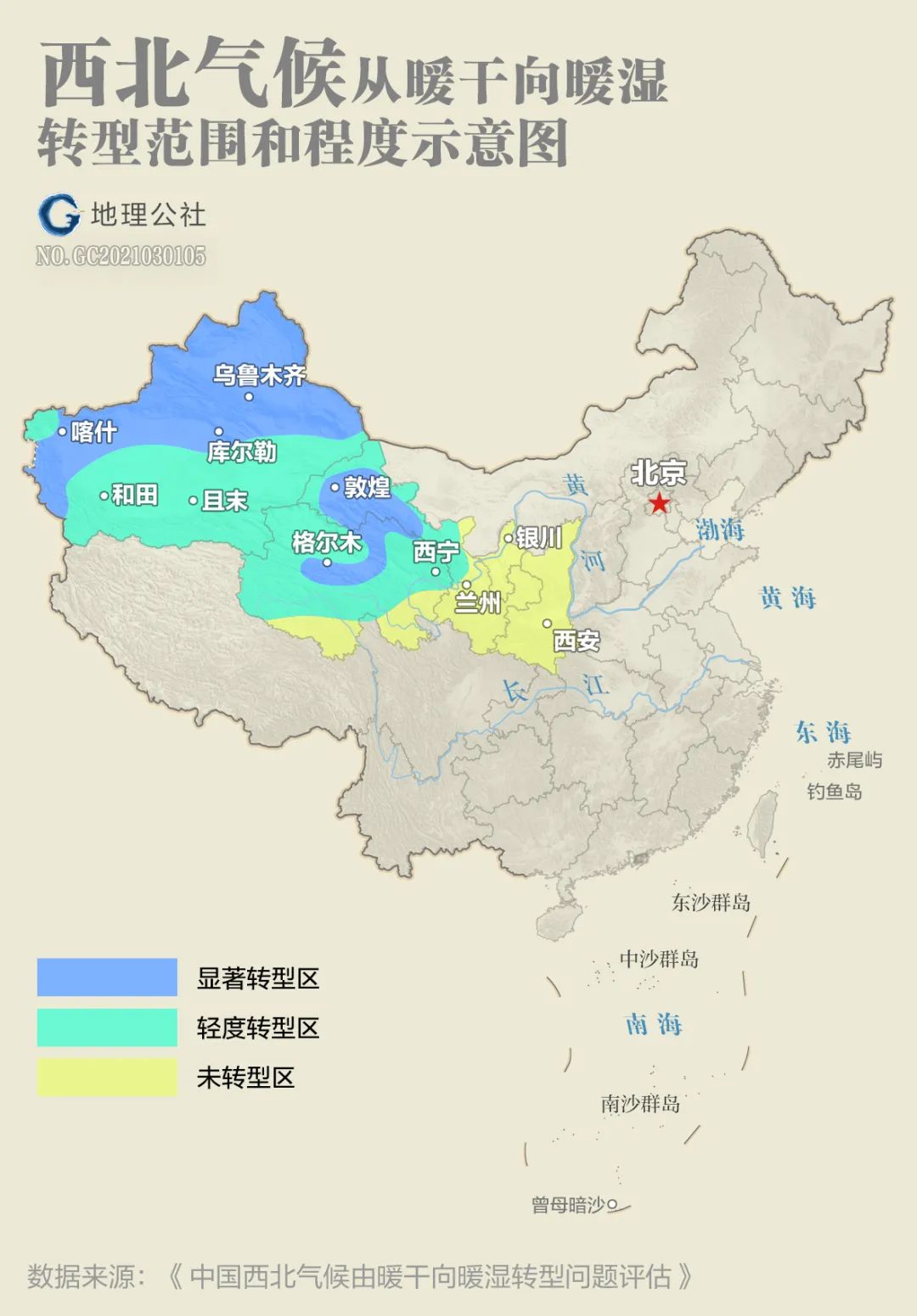
By comprehensively assessing climate transition signals such as river runoff and lake water levels, Shi Yafeng divided the climate change in the northwest region into three regions: significant transition area (significant wetting occurs), mild transition area (wetting trend occurs) and no Transition zone (sustained warm and dry zone).
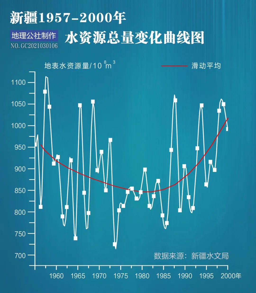
hydrological data
is a very important climate change signal
Among the 26 major rivers in Xinjiang
Average annual runoff of 18 rivers
have significantly increased
Average annual runoff from 1987 to 2000
Compared with 1956-1986
The increase is 5%-40%
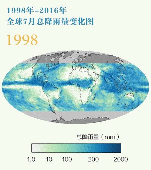
precipitation
is a more direct indicator
Average annual precipitation from 1987 to 2000
Comparison with average from 1961-1986
Northern Xinjiang increased by 22%
An increase of 33% in the South
Tianshan increased by 12%
Qilian Mountains, central and western Hexi Corridor
and parts of the Qinghai Plateau
The average increase is between 10%-20%
(Please view horizontally)
The Heihe River originates from the Qilian Mountains. Since the mid-to-late 1980s, the runoff from the mountains has continued to increase. Photography | Charlie
As precipitation increases
Analysis using NOAA/AVHAR satellite monitoring data
Discovery 1981-2001
Areas with significantly improved vegetation in the entire northwest region
Reach 13%
The main improvement areas are
Near Hotan in western, northern and southern Xinjiang
Gansu Hexi Corridor and nearby Lanzhou
Near Yinchuan Plain in Ningxia and Yulin in northern Shaanxi
Improvement of vegetation
and a reduction in wind speed
greatly reduced
Frequency of sandstorms
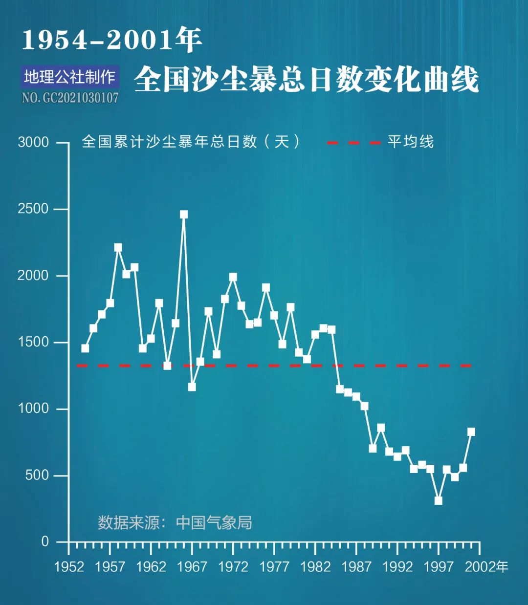
1990s compared to 1960-70s
Total number of sandstorm days nationwide
cliff fall
year 2002
When Shi Yafeng’s team assessed climate change in the northwest
The increase in precipitation is mainly in
Northwest Territories Midwest
Including Xinjiang, Gansu Hexi Corridor and parts of Qinghai
And predicted the eastern part of the Northwest Territories
It will also change to warm and humid conditions
Verified by more than ten years of changes
Monitoring data display
after 2004
Precipitation in eastern Shaanxi and Gansu is as expected
start to increase slowly
Precipitation has increased more significantly in recent years
And ground vegetation
It also gradually recovered at a speed visible to the naked eye.
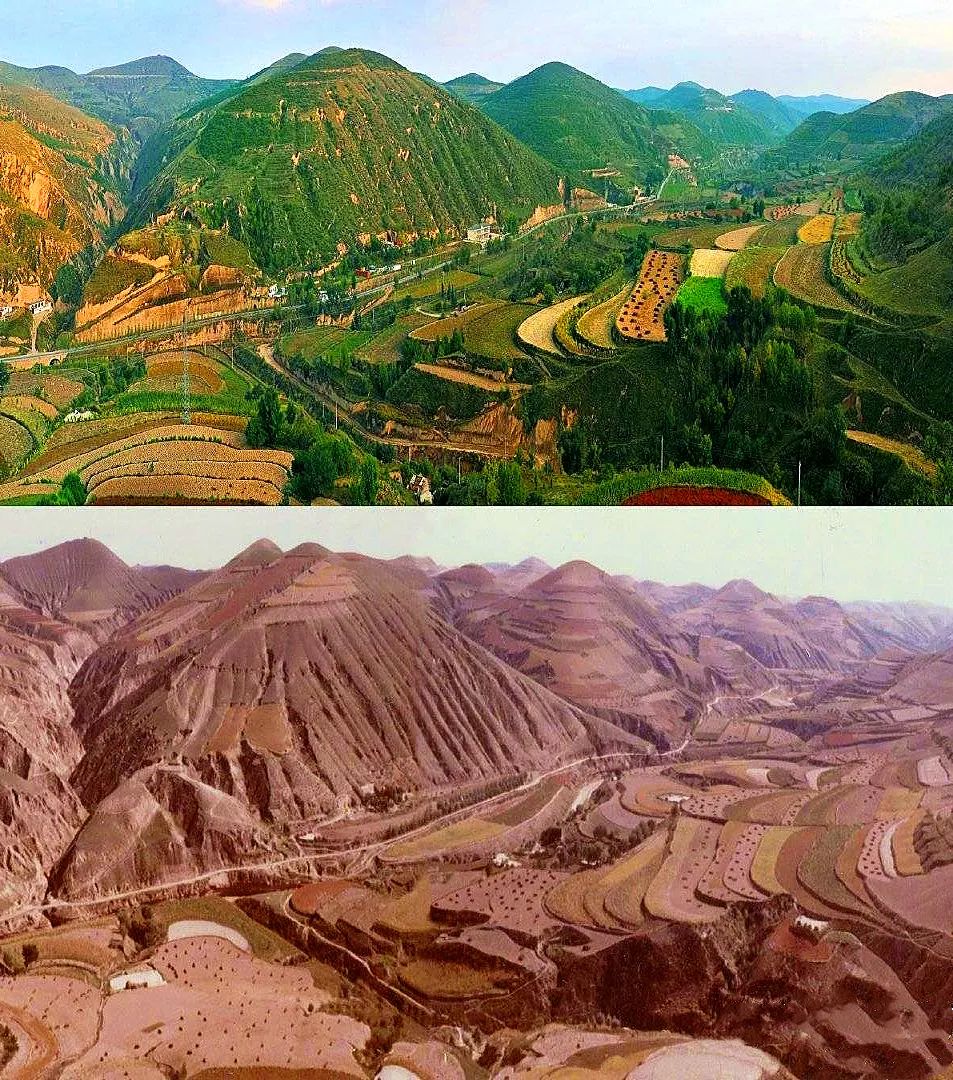
Sanguyao Village, Tiebian Town, Wuqi County, Yan'an City, Shaanxi Province is located on the Loess Plateau. The picture shows a comparison of the scene in 2012 (top) and 1984 (bottom). Photo courtesy | Xinhua News Agency
Mu Us Sandy Land is one of the four major sandy lands in my country.
Located between Yulin City, Shaanxi Province and Ordos City, Inner Mongolia
The total area is 38,000 square kilometers
It is about the same area as Taiwan
in recent years
The ecological condition of the sandy land has improved overall
The desertification land control rate in Yulin City has reached 93%
Mu Us Sandy Land as a noun
will become history
People retreat from the sand
Go to green and retreat to sand
The historical transformation of Mu Us Sandy Land can be attributed to
70% are alive
Thirty percent is in the sky
after 2000
Local precipitation increases by an average of 5.7 mm per year
nearly 50 years
The average annual precipitation in the southern edge of Mu Us Sandy Land is 425 mm.
In 2017, it increased to 637 mm
Equivalent to
Beijing’s annual rainfall
after 2000
Warming and humidification trends in northwest China
more obvious
and began to expand to the Qinghai-Tibet Plateau
nearly 20 years
With the increase in precipitation
Lakes on the Qinghai-Tibet Plateau are expanding significantly
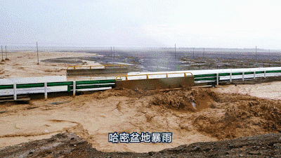
Extreme precipitation events have also increased significantly
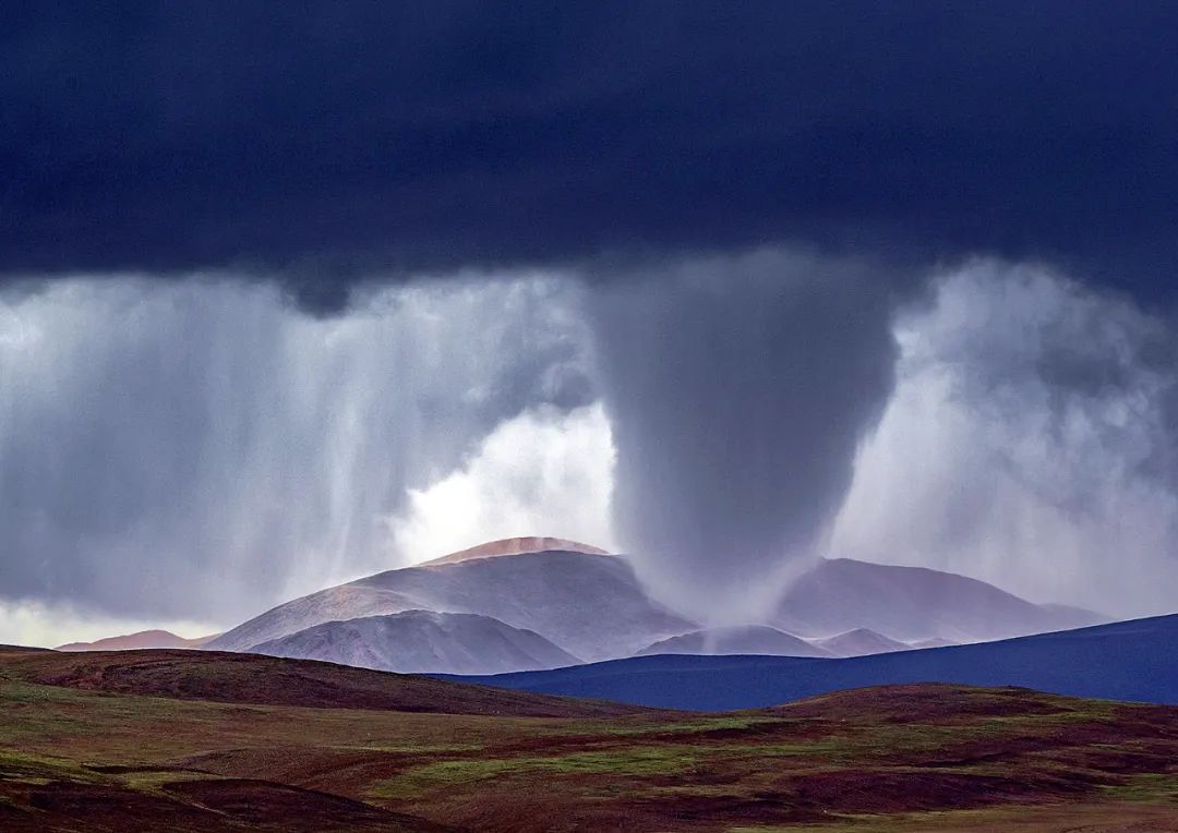
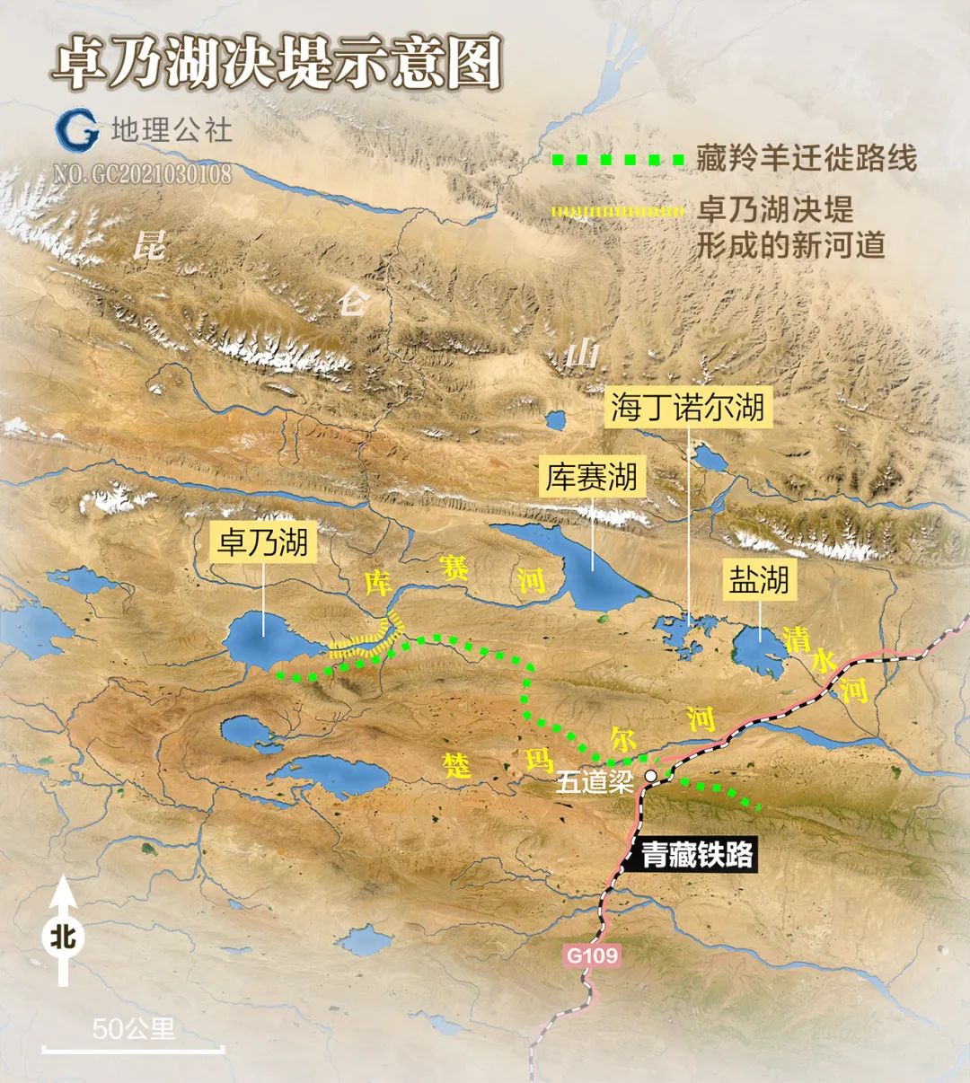
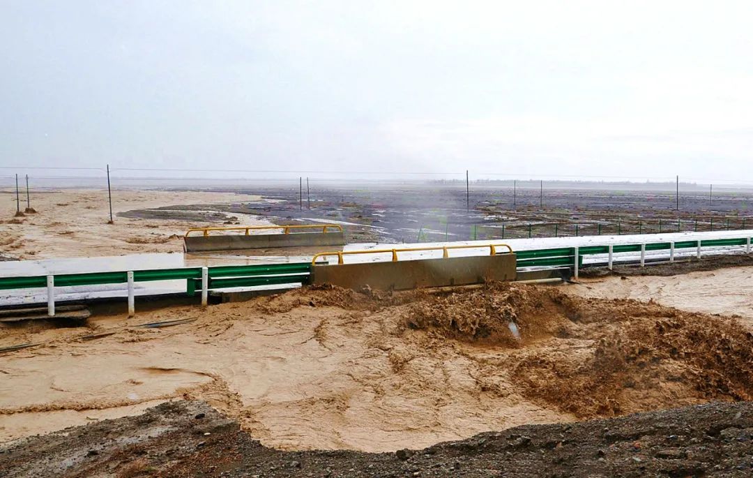
Mid-August 2011
Rain continues in the hinterland of Hoh Xil
The water level of Zhuonai Lake rises rapidly
September 14
triggered the East Coast Rout
Overflowing flood water on plateau surface
Breaking out of a deep and wide ditch
More than one billion cubic meters of lake water
galloping down
Flows into Lake Kusai in the east
trigger a chain reaction
Then the water of Lake Kusai overflowed
It is connected to Lake Hedinauer and Salt Lake to the east
July 2020
The area of the salt lake expanded to 200 square kilometers
The lake level is only 4 meters lower than the lowest point on the watershed
once collapsed
The lake water finally passes through Qingshui River
It flows into the Chumar River, the northern source of the Yangtze River.
Becomes the northernmost source of the Yangtze River
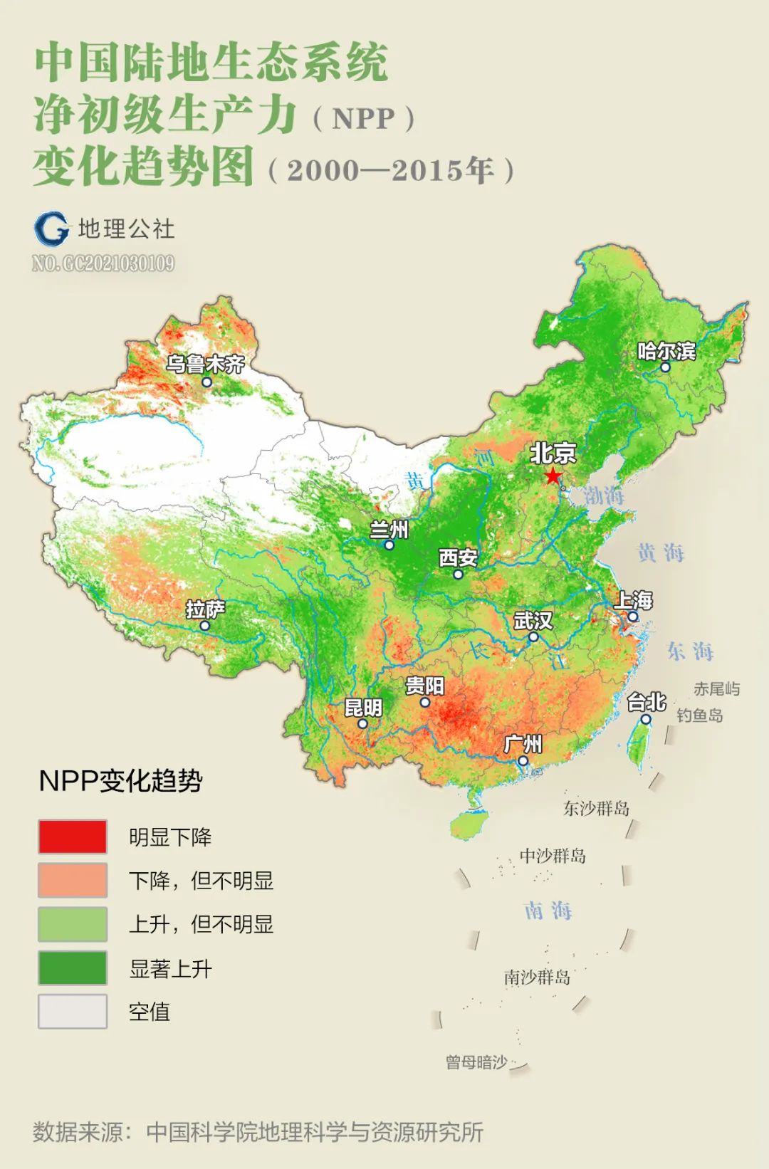
The entire six northwest provinces
due to increased precipitation
Vegetation growing season NPP
plant net primary productivity
Overall, there is an increasing trend
And in 1999
mutate
From an insignificant increase to a significant increase
 Cartography丨Geography Commune丨Du Zhuoyi
Various monitoring data display
The warm and humid period speculated by Shi Yafeng
Appear early in the northwest and east
the entire northwest
Already showing a comprehensive trend of warming and humidification
But this trend belongs to
Generations
centenary
Or is it climate change on a longer time scale?
The scientific community has not yet reached a conclusion
丨
3 Warm China, the changes of the century are still short-lived
Northwest China is located within the Asian continent
Stay away from ocean water vapor sources
Deserts and Gobi are widespread
Replenishing the air with local water vapor is severely restricted
thereby reducing the precipitation increase rate
for hundreds of years
Excessive groundwater development
vegetation destruction
Soil moisture decreases
These also increase the difficulties of climate transition
 Cartography丨Geography Commune丨Du Zhuoyi
in recent years
River runoff increases in northwest China
In addition to increased precipitation
Increasing glacier melting is an important factor
There are modern glaciers in the northwest arid region
22240 items
Area 27974 square kilometers
As climate warms
Glaciers melt and expand
Estimated period 1960-1995
Northwest glaciers have reduced by 1,400 square kilometers
Equivalent to a reduction of 8%
(Please view horizontally)
Glaciers in the Qilian Mountains are retreating more seriously
According to China’s Second Glacier Inventory Statistics
there are 2,684 glaciers in the Qilian Mountains
Area 1597 square kilometers
Compared with the first glacier catalog
The glacier retreated by 420.81 square kilometers
From 1956 to 2010
One-fifth of the glaciers have disappeared
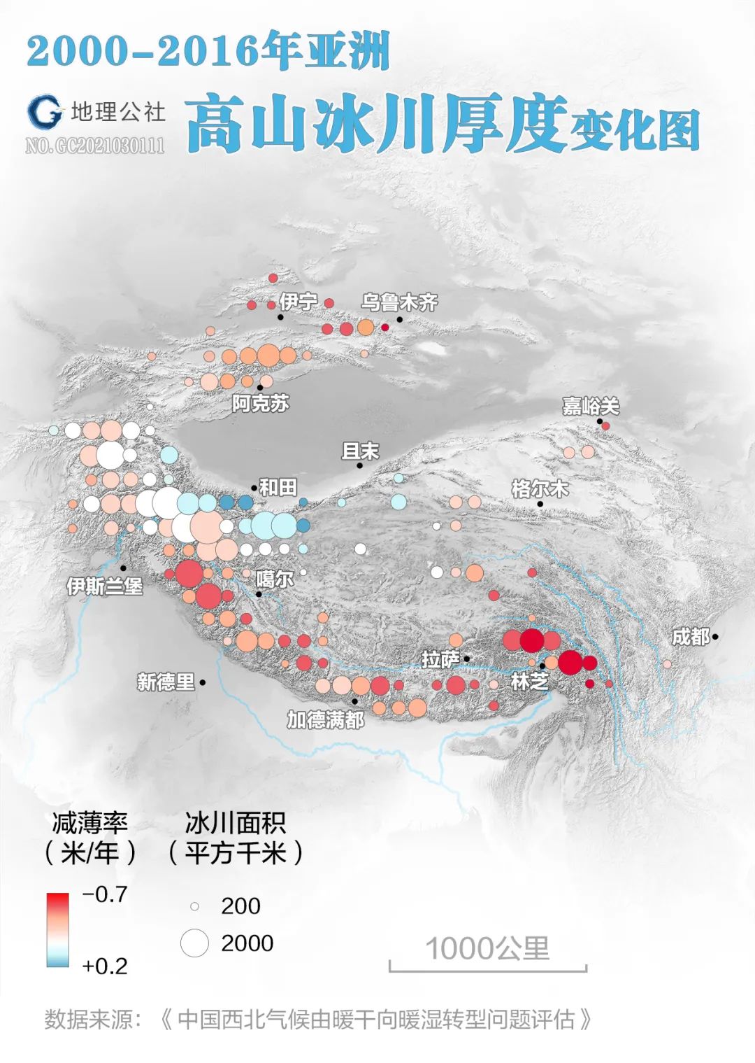
Cartography丨Geography Commune丨Du Zhuoyi
When the thickness of the glacier becomes seriously thinner and the ablation amount reduced by rapid retreat at the tip exceeds the increased ablation amount on the surface, the glacier melt water will decline rapidly.
Prospects for water resources in northwest China
Jiang Tong, chief researcher at the National Climate Center
not optimistic
As the glacier retreats to a certain extent, it will
No ice to melt
He believes that by 2050-2070
River runoff in the Northwest Territories is likely to
no more increase
The climate and geography pattern determines
Northwest China will not become Jiangnan
(Please view horizontally)
Academician Ding Yihui
Deputy Director of the National Expert Committee on Climate Change
His views on the prospects of warming and humidification in the northwest
cautiously optimistic
Through water vapor source analysis
Ding Yihui discovered
Contribution of external water vapor to precipitation efficiency and precipitation amount
Far greater than the contribution of local water vapor
Therefore, the increase in external water vapor causes the northwest to become humid.
main reason
Even if glacier melt water decreases in the future
As long as the external water vapor does not decrease,
Northwest river runoff by mid-21st century
It is still possible to increase
in particular
External water vapor in the northwest mainly comes from
Pacific Ocean
arabian sea
indian ocean
As the Arctic warms
Rapid melting of sea ice
Water vapor from the Arctic Ocean is also increasing
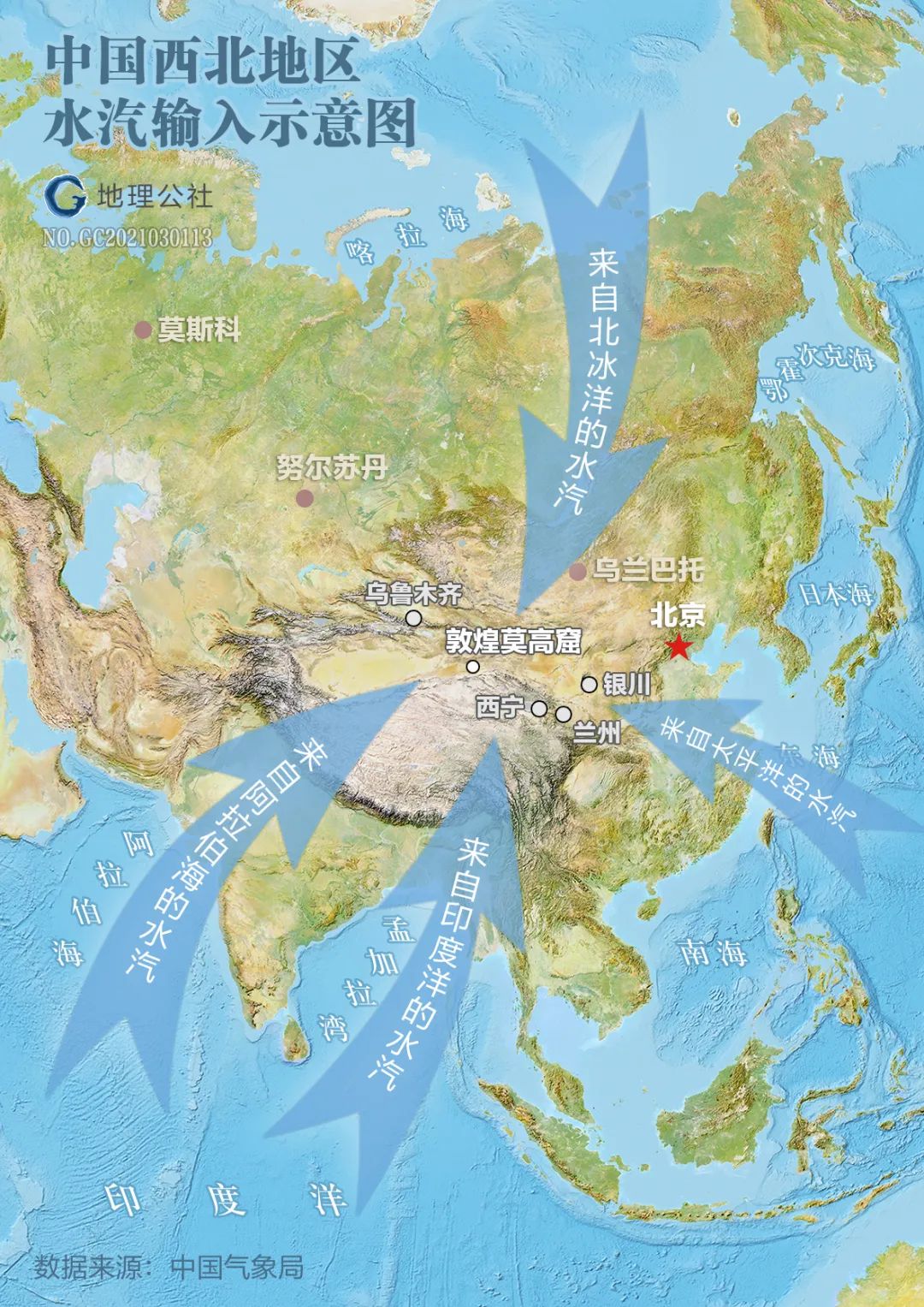
Water vapor transport in the northwest region
not only from the Atlantic and Arctic oceans
The influence of westerly airflow
There is also the invasion of the South Asian monsoon and the East Asian monsoon
At the same time, it is also affected by the topography of the Qinghai-Tibet Plateau.
profound influence
By analyzing seasonal differences in wetting in the northwest
Ding Yihui thinks
The main cause of warm and humidification in the northwest
It is not a local or regional reason
It is mainly caused by changes in large-scale circulation
Global warming drives water cycle intensification
It may be due to the warm and humid climate in the northwest
root cause
Animation丨Geographic Commune丨Du Zhuoyi
According to Bengtsson L (1997), when greenhouse gases double, the amount of water vapor transported from the ocean to the land will increase by 11%, the evaporation on the land will increase by 5%, and the precipitation on the land will increase by 8.5%, returning from the continent to the ocean. The amount of runoff will also increase by 10.3%. His estimated doubling time for greenhouse gases occurs between 2030 and 2040. Data source: "Assessment of the climate transition from warm-dry to warm-wet in northwest China"
2019
The global average temperature is higher than before the industrial revolution
1.1 degrees Celsius higher
2009-2018
The warmest 10 years in the past 1,700 years
influenced by
Since 1980
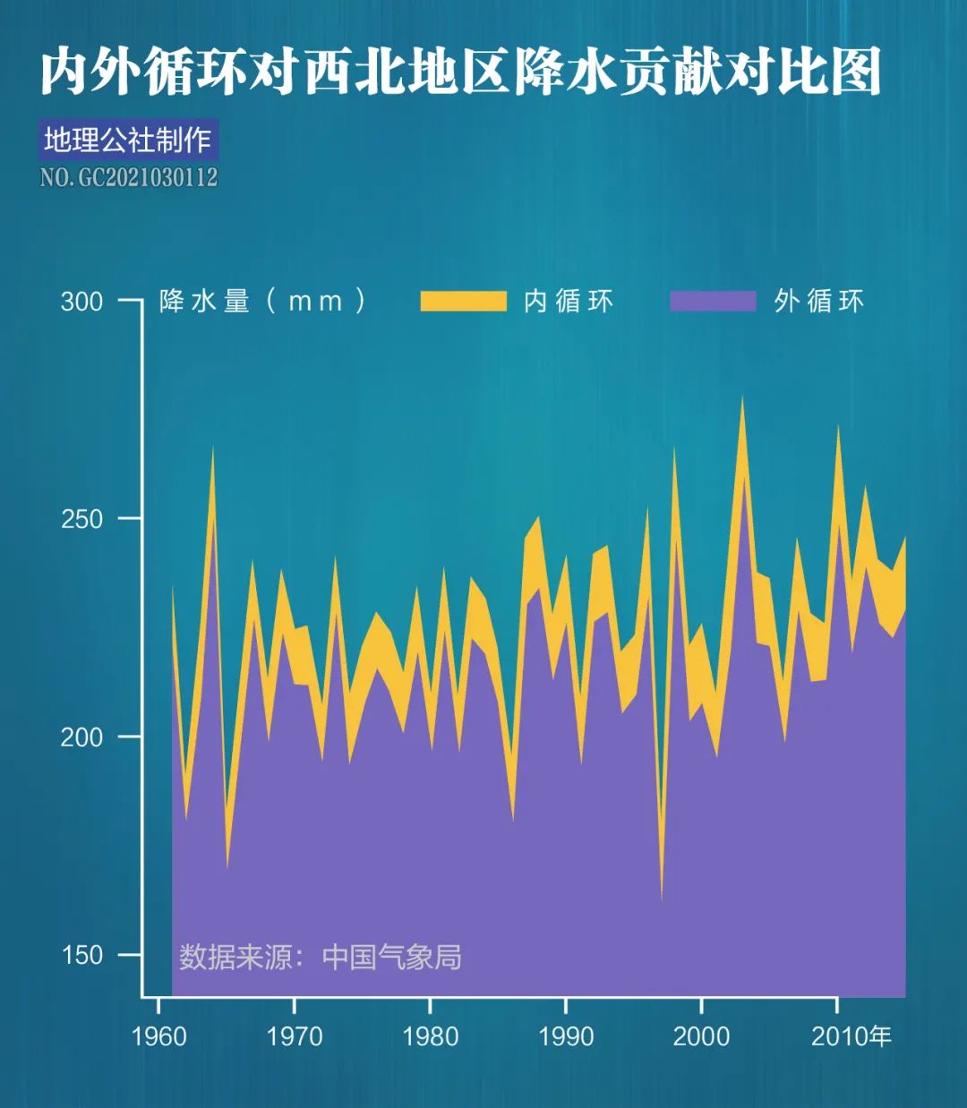
The global water cycle is intensifying
Global land precipitation since 1950
are increasing
After 1990s
There is a rapid increasing trend
Animation丨Geographic Commune丨Du Zhuoyi
Data source: NASA’s Global Rainfall Monitoring Satellite
In the context of global warming
Northwest China
Since the end of the Little Ice Age from the 1860s to the 1880s,
Basically developing towards warm and dry conditions
Since the 1980s
Temperatures are rising more strongly
Actual measurement records show
Western China temperature
Rising with a trend of 0.3℃ every 10 years
1987-2000 compared with 1961-1986
The average temperature in the northwest region increased by 0.7℃
past 30 years
These are the 30 warmest years in the past 1,400 years
The rising temperature
is approaching
Temperatures during the interglacial period 30,000 to 40,000 years ago
then
China has a special warm and humid climate
There are many rivers and lakes in the west
Rich broadleaf tree species
Qinghai-Tibet Plateau precipitation
40-100% higher than modern ones
The lake area of the Qaidam Basin reaches
25,000 square kilometers
The lake level is 50-60 meters higher than modern times
Shi Yafeng’s report on climate transition in northwest China
Evaluation report in progress
Comprehensive consideration of changes in sunspot cycle length
and changes in greenhouse gases and aerosols
Forecast to the end of the 21st century
The temperature increase in northwest China may reach 2.67℃
According to the records of Guriya ice core
This temperature is equivalent to
The heyday of the Holocene Warm Period 6000-7200 years ago
at this time
At the time of Yangshao culture period
China's agriculture and population have developed greatly
The annual precipitation in Qinghai Lake is 70%-80% higher than in modern times
Inland lakes are at high water levels
The desert is shrinking

Animation丨Geographic Commune丨Du Zhuoyi
The Yangshao Culture is an important Neolithic painted pottery culture in the middle reaches of the Yellow River, which lasted from about 5000 BC to 3000 BC.
Forecast to 2050
The average temperature in the northwest provinces and regions will rise by 1.94℃
This temperature is equivalent to
The Qin-Han Warm Period around the 3rd century AD
at this time
The Zhuye Ze in Minqin, Gansu Province covers an area of more than 4,000 square kilometers.
There are 1.09 million soldiers and civilians living on the Ordos Plateau
Lop Nur is a large lake with abundant water and grass.
Nourished the 14,000 population of the ancient Loulan country
"The vastness is three hundred miles, and its water pavilions are inhabited. It does not increase or decrease in winter or summer."
Become the throat of the Silk Road
Similar studies on paleoclimate show that
Warm period from hundreds to thousands of years
Usually characterized by a warm and humid climate
Increased precipitation
Rich runoff
Lush vegetation
Meteorologist Zhu Kezhen published in 1972
"Preliminary Research on China's Climate Change in the Past Five Thousand Years"
This supports the conclusion
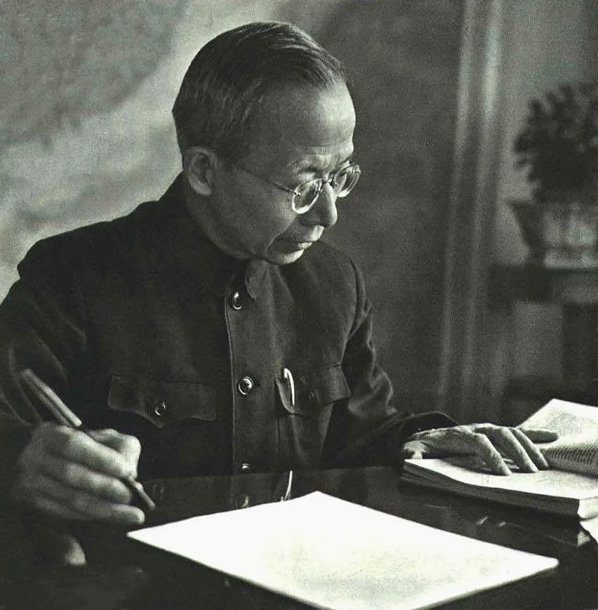
Zhu Kezhen (1890-1974), As the founder of modern meteorological science in China, his series of foundational studies on climate change have basic scientific significance for today's understanding of this major global issue. Photography|Ao Enhong
Combining history, phenology, local chronicles and instrumental observations
Zhu Kezhen summarizes climate change over the past 5,000 years
It is roughly divided into 4 warm periods and 4 cold periods.
Between 3000 B.C. and 1100 B.C.
first warm period
Both sides of the Yellow River are covered with green bamboos
Wild elephants run in the Central Plains
The second warm period corresponds to
Spring and Autumn Period, Warring States Period and Qin and Han Dynasties
Qilu area can produce two crops a year
The third warm period was the Sui and Tang Dynasties
There is no ice or snow in Chang'an City in winter
Can grow plum blossoms and tangerines
The fourth warm period corresponds to the Northern Song Dynasty to the middle Yuan Dynasty
The degree of recovery is not high
The northern boundary of the elephant herd has moved to the south of Nanling
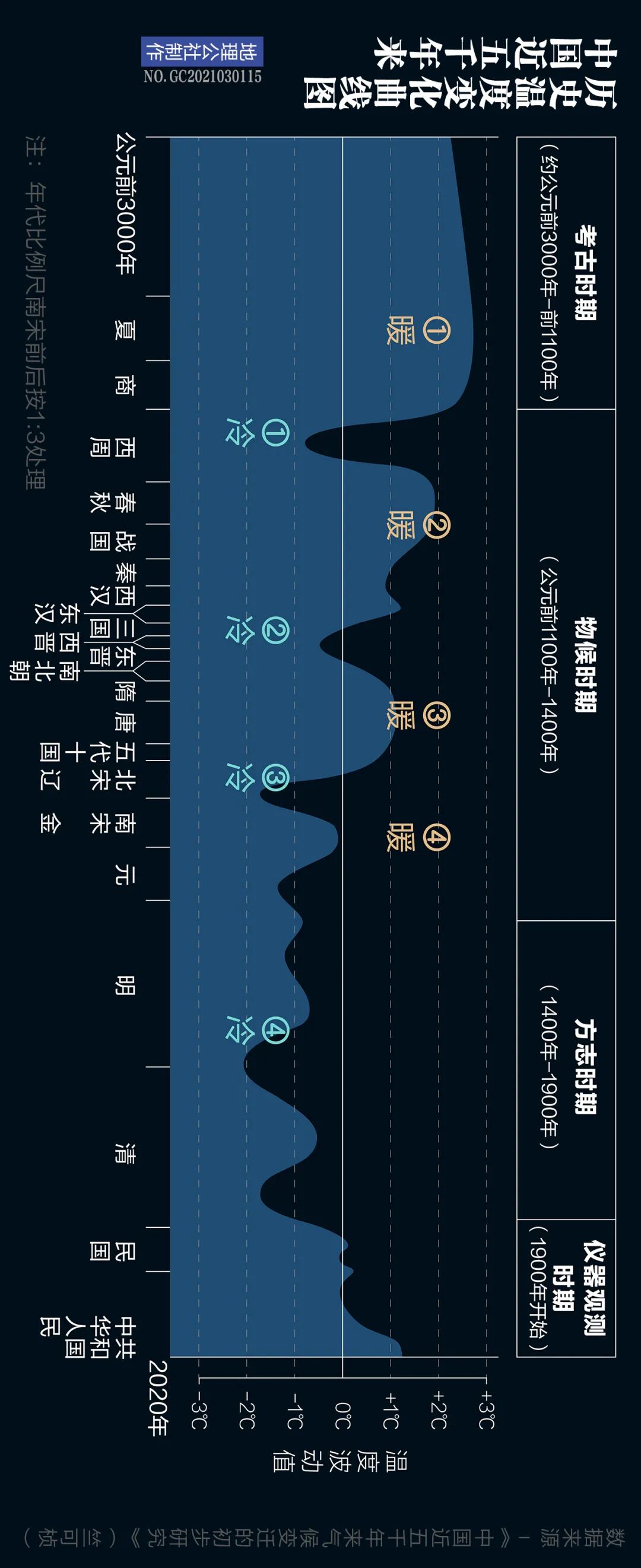
Cartography丨Geography Commune丨Du Zhuoyi
From the analysis of the temperature change curve, China's current average temperature is similar to that of the third warm period in the Sui and Tang Dynasties.
Warm China
ongoing tense
This is not global warming
a small interlude
It’s not that far removed from our lives.
After dinner
climate
This hand that changes everything
in the present and the foreseeable future
It is bound to have an impact on the world as well as our country and nation
produce immeasurable impact
Mr. Zhu Kezhen’s paper was published in
1970s
Although it was not clear at that time whether to enter the next
warm cycle
But it revealed the tip of the iceberg of China’s warming
Laying a solid foundation for the theory of cold and warm cycles
Mr. Shi Yafeng started from the northwest warm and humidification
bold hypothesis
Be careful to verify
The relay is completed
A blueprint for China’s fifth warm cycle
"In old age, I dare not forget to worry about the country, but I am determined to rejuvenate the nine states."
Chinese older generation scientists
With their serious academic attitude
Invincible courage and perseverance
The road is blue
I just want to do something for the country and nation that have gone through vicissitudes of life
Identify the direction
escort
People often because of scientific rigor
and labeling scientists as stereotypes
But actually
The feeling of taking the world as one's own responsibility
It is often the more valuable character of scientists
for them
Guided by a sense of contribution
Exploration and sacrifice regardless of gain or loss
both happy
More free
Auspicious snow in Qaidam Basin. Photography | Master
"The lush green summer and colorful autumn
Seems like a distant past
The desert land will lie under the snow-white cloak
Close your eyes and recall the passing days and months
The earth will not age
Winter is just a peaceful dream
It will wake up in the warm spring breeze
Make yourself young again”
——"The Ordinary World" Northern Shaanxi writer Lu Yao
Comments
No comments yet