On the evening of the 27th, we checked into the Liancheng Ecological Hotel on Xinyuan Zexin Road. When we checked in, the sun had not yet set. Xiaoxia told us that this was the "most luxurious" hotel we stayed in on this trip. It covers a very large area. The hotel's yard is like a park, with many big trees. The houses are shaded by the big trees, and the environment is very good. After a day of running around, everyone was a little tired. I was confused for a while just after coming out of Kalajun. In the afternoon, I passed Tekes, and it was flat. I asked the two ladies to talk to Xiaoxia. Xiaoxia said, no, we can be confused if we want to be confused, he can do it. We think it's better to have someone to talk to the driver for a long drive. I was confused for about half an hour, and I didn't squint anymore after waking up. The sleep I lost while taking pictures of the stars was not replenished. I don't know how many times my eyes fought on the road, so I felt very tired.
After we settled in, Xiaoxia took us to a restaurant just across the street for dinner. The restaurant was at the street corner, which seemed to be Qingnian Street. The row of shops on the ground floor were all for building materials, ceramics and car repairs, and this one was the only restaurant. The restaurant was quite large, occupying at least 2 storefronts. The owner was a Uyghur, although most of the people in Xinyuan were Kazakhs. There were four or five waiters in the restaurant, and we could understand the Mandarin they spoke. We sat in the inner room and ordered some food, including pilaf, barbecue, yogurt, etc. There must have been more than one staple food, but I have forgotten what they were.
After dinner, I went back to my room to wash up. I didn't want to wash clothes because I had enough clean clothes to change into. I had just finished washing when Xiaoxia came back after filling up the car with gas. She told me that today, the window of our room faces east, so we can take pictures of the sunrise in the room tomorrow morning.
Xinyuan County is located at the eastern end of the Yili River Valley. Gongnaisi River Valley , Surrounded by mountains on three sides, embracing the Gongnaisi River and open to the west, it has the Gongnaisi Grassland, one of the four largest river valley grasslands in the world. The Nalati Mountains in the south of the Gongnaisi Valley start from the Erkenda Pass in the east and are connected to the Kutao Mountains in the west. To the north are the Andir Ulu Mountains, the Arshan Mountains, and the Awurele Mountains. The entire mountain range is high in the east and low in the west, steep in the south and gentle in the north.
New source, Formerly known as Gongnaisi, It was the land of the Sai people before the Qin Dynasty. From the Han Dynasty to the Jin Dynasty, it belonged to the Wusun territory. It was soon the Yueban Kingdom. During the Sui and Tang Dynasties, it was dependent on the Western Turks (and changed its name to the Shihana Kingdom). In the Song Dynasty, it belonged to the Eastern Karakhanid Dynasty. From the Liao Dynasty to the Yuan Dynasty, it was under the jurisdiction of the Alimali Province. In the Ming Dynasty, it belonged to the Weiwuerd. All of them were nomadic lands. After the Qing Dynasty unified Xinjiang, Gongnaisi was assigned to the Eleuth Camp Ranch.
The eighth year of Guangxu In 1882, the Kazakhs were allowed by the Qing government to move to Gongnaisi to live as herdsmen. The following year, the system of 1,000-household chiefs was established. When Ningyuan County was established in the 14th year of the reign of Emperor Guangxu (1888), it was part of Ningyuan. In the 19th year of the Republic of China (1930), Gongliu County was established, and Gongnaisi was its eastern pastoral area. Gongnaisi was separated from Gongliu County in 1939 and the Qiakeman Administrative Office was established. In 1942, it was renamed Xinyuan Administrative Office. In 1946, the county government was implemented. , that is, Xinyuan County.
Gongnaisi, which means "green valley" in Oirat Mongolian (it was the pastoral area of the Oirat tribe during the Yuan, Ming and Qing dynasties), means the place where the sun rises in Kazakh. Because it is located in the upper reaches of the Gongnaisi River, it is also named "Xinyuan", which means newly reclaimed grassland or newly opened wilderness. I had a sound and comfortable sleep all night. I woke up before sunrise and opened the curtains a little. The light was a bit dazzling and there was no morning glow, so I just continued to sleep.
On the 28th, our itinerary was relatively simple. We went from Xinyuan to Bayinbuluke, and then visited the winding and zigzag paths of Bayinbuluke Scenic Area. We stayed in Bayinbuluke Town. This was the only day of the entire trip when we didn't need to rush. To get to the restaurant, we had to walk a long way under the tall trees. Just like the courtyards in the mainland back then, there were big trees planted on both sides of the wide road, but the trees here were not in a row, but in a forest. The architectural style of the restaurant was also the same as the courtyard buildings in the 1950s and 1960s, with brick walls and sloping roofs. I guess this was originally the location of military reclamation or the government, and now it is used for civilian purposes. I asked Xiaoxia, and Xiaoxia said he didn't know the original purpose either. Because we were not in a hurry to get on the road, after dinner, we took a walk around the yard.
Not far from the county seat, I found a road sign for Nalati Airport, and then I learned that there is an airport in Xinyuan. Nalati Airport is 12 kilometers away from Xinyuan County Highway, 16 kilometers away from Yeguolin Scenic Area, and 16 kilometers away from Nalati Scenic Area. 58 kilometers , which can guarantee the full take-off and landing of all ATR and Boeing 737 series aircraft. Having an airport will greatly facilitate travel .
Nalati Grassland, also known as Gongnaisi Grassland, is located on the northern slope of Nalati Mountain, south of the Gongnaisi River. G218 passes through the north side of the river, so transportation is convenient. Nalati Grassland is a mid-mountain grassland developed on the ancient alluvial layer of the Tertiary Period . It means "White Sun Slope" in Turkic language. It is located in the east of Nalati Town, Xinyuan, about 110 kilometers away from Xinyuan County. Nalati Grassland is a subalpine meadow plant area, one of the four largest grasslands in the world. It has been a famous pasture since ancient times. Legend has it that during Genghis Khan's Western Expedition, a Mongolian army marched from the depths of the Tianshan Mountains to Ili. It was spring, but the mountains were filled with wind and snow. Hunger and cold made the army exhausted. They did not want to cross the mountains, but in front of them was a tapestry of flowers. The vast grassland, densely covered with springs and gurgling water, seemed to have entered another world. At this time, the clouds opened and the sun rose, and the setting sun was like blood. People couldn't help shouting "Nalati (there is the sun), Nalati" and so they stayed got this place name.
The Nalati Grassland is on our way today. The sun is shining brightly in Nalati today, with white clouds and snow-capped mountains in the distance. It is very beautiful. We have fully enjoyed the grassland scenery and did not include Nalati as a destination for this trip. A large white yurt appeared on the side of the road. I couldn't see where it was. Xiaoxia said that it was the first village in Kazakhstan and was home to the largest number of Kazakhs in the world. However, I later checked the information and introduced that it was built by Xinyuan. Nalati Folk Culture Tourism Scenic Spot, with the theme of promoting Kazakh national culture and positioned in folk customs tourism, is a Kazakh national cultural industry base integrating tourism, vacation, leisure, entertainment, national cultural display, performance, exhibition, etc., with the purpose of It is to enable tourists to fully feel and experience the charm of Kazakh national culture. Whether this is the case or not, you can only experience it yourself. If we don’t go there, we don’t know. 
Not far after Nalati Town, the mountains in the north and south closed together. After about ten kilometers, there was a road going north. The road signs pointed to Dushanzi and the bank of Gongnaisi River. There is a parking lot, there is a small river that flows into the Gonnasi River, and there is a gas station and a checkpoint on the north side of the road. This place is called "Kilometer 0", but I didn't figure out which road starts from it.
The water in the river is not big, the water in Gongnaisi River is slightly turbid, but the water from the mountain stream just now is very clear. Since we had been driving for nearly 2 hours, we stopped here to take a rest. I took a leisurely walk by the river and enjoyed the tranquility. Set off again, after traveling less than a kilometer, the car turned right across the Gongnaisi River and entered another valley that merged into the south. The road sign indicated that there were still 57 kilometers to Bayinbuluke and 318 kilometers to Kuqa.
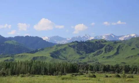
The road became more twists and turns, and the gradient also increased significantly. A lady asked if we were entering the G217 Duku Highway, and Xiaoxia said that we were. The hillsides on both sides of the valley are covered with tall spruce trees, and the scenery is very beautiful. As the altitude rises, the scenery also changes. The river valley cuts deep at the foot of the mountain, and piebald pastures gradually appear on the hillside. Finally, we came to the top of the mountain that we saw from the bottom of the mountain. There was still a thin layer of snow on the hillside. From time to time, a long snow wall appeared on the mountain side of the road, leaning against the slope protection wall.
As we get closer to the top of the mountain, the deep valleys become softer and gentler, and the large pastures are really eye-catching. Turanshala at 2700m is the highest point to Bayin. In fact, this point is not obvious. At the top of the slope, the grassland is endless. We have entered the Bayinbulak Grassland. The vast green carpet in front of us gives people a sense of enlightenment, like suddenly encountering a peach blossom garden.
Bayinbulak Grassland was formerly known as Yuledus Grassland, Zhuledus Grassland, and Yuludus Grassland. Because it is mainly located in Bayingolin Mongolian Autonomous Prefecture and Bayinbuluk District in the northwest of Jing County, Xinjiang, it is also called Bayinbulak Grassland. . Bayinbuluk means "never-ending sweet spring" in Mongolian (it means "star plain" in Turkic). As far back as 2,600 years ago, Gushi people were active here. During the Ming Dynasty and the early Qing Dynasty, the Huite tribe of Mongolia in the desert nomadically roamed the Bayinbulak grassland. In the 39th year of Qianlong's reign in the Qing Dynasty (1774), the Torgut Mongolian tribe led by Wobasi who returned to the east was settled.
Bayinbulak Grassland is located in an intermountain basin at the southern foot of the middle section of the Tianshan Mountains. It is a natural scenic area integrating mountains, basins, and grasslands. It is surrounded by snow-capped mountains. It has an altitude of about 2,500 meters and an area of 23,835 square kilometers. It is the second largest grassland in China. , is also the largest alpine grassland in China. The grassland has flat terrain and abundant water and grass. It is a typical grass meadow and one of the most important animal husbandry bases in Xinjiang. The mountains surrounding the grassland are all above 3,000 meters above sea level. It is a typical alpine steppe grassland, alpine meadow grassland, alpine swamp grassland and mountain meadow grassland. The grassland water supply is mainly a mixture of ice and snow water and rainfall. In some areas, there is groundwater supply, forming a large number of swamp grasslands and lakes. Since Bayinbuluke Prairie is less affected by human activities, it has preserved a variety of rare species in the world and has become an ideal breeding habitat for swans and other wild animals. It is a swan reserve with the largest wild swan population in China. The landscape is basically in its original state and is monopolistic and irreplaceable.
Erbin Mountain stretches 170 kilometers from east to west and is about 50 kilometers wide from north to south. It divides the Bayinbulak Prairie into two, forming two basins. More than a thousand springs are distributed throughout the grassland, and merge with the trickle of melted ice and snow into the basin to form the Kaidu River, the mother river of Bazhou. The ancient Kaidu River crosses between the two basins, forming large and small oxbow lakes and swamps on the grassland. The Kaidu River nourishes the prairie and nurtures generations of life on the prairie.
Bayinbuluk National Nature Reserve is located in the bottom swamp of the Longludus Basin, with a total area of 1,369 square kilometers, a core area of 452 square kilometers, a buffer zone of 698 square kilometers, and an experimental area of 219 square kilometers. The climate in this area is cold and humid, with spring and autumn, lots of rain and snow, dense mountain springs, wide natural pastures, and abundant aquatic plants. The annual average temperature is -4.6°C, the extreme highest temperature is only 25.4°C, and the extreme lowest temperature reaches -40.5°C. There is a lot of natural precipitation and snowfall all year round. There is a lot of snow and heavy fog. The frost-free period is very short, and the longest frost-free period is only 28 days. Bayinbuluke Nature Reserve has nearly 140,000 hectares of waters covered with lakes and swamps. It is the southernmost limit of wild swan breeding in the world and is known as the "Swan Lake".


Xiaoxia asked us to pay attention to the sheep here for a while, saying that the sheep here are different from other places. The black-headed ones are particularly beautiful. After seeing the sheep here, we want to see the sheep in other places. Just as we were talking, on the hillside ahead, a large group of sheep were walking towards us on the green grass. They were like a white cloud floating on the green land. The area that had bypassed the ridge and entered our field of vision was no smaller than a football field. There were thousands of them, and there was a puff of dust on the other side of the ridge. A few friends were taking pictures in the bay of the parking island. A herdsman wearing a thick Chinese tunic and an ordinary hat passed us on horseback with two dogs. The dogs were not impressive at all.
After crossing the ridge, there were several yurts in the gentle valley. Xiaoxia told us that Kazakhs like to call these yurts and don’t want to call them yurts. On the hillsides on both sides, there are large groups of sheep grazing, and some tourists are playing. As the car moves forward, flocks of sheep appear in the field of vision, often all over the hillside. It is difficult to tell how many flocks there are, let alone how many there are. From a distance, they look like a white patch, and from a close distance, they look like white. You can see that different parts of the sheep are dyed with many colors, which should be used to distinguish the owners.
At first, the two ladies shouted in surprise: "Sheep, sheep, sheep, there are some here too," but after a while they couldn't see them anymore and stopped shouting. I was sitting in the passenger seat, so I could see where the sheep were early on, so I took photos easily. The two ladies asked me to take more photos, and just ask me for photos when I get back. There is a small ditch on the side of the valley. There is no water in the ditch, and the sheep are on both sides of the ditch. A large group of sheep is walking down the hillside, and its forward has reached the road. We stopped the car and let the sheep pass in front of us. An oncoming car came towards us. It seemed a little impatient and honked a few times, trying to squeeze a way out of the sheep. As a result, the sheep stood stunned on the road for a while, and then stopped directly. Some of the people running across the road were in a daze, while others ran back a few steps and slowly crossed the road again. The road became more lively.


I saw the Kaidu River ( Kaidu describes a graceful and gentle curve, the river is the legendary "Tongtian River" in the mythical novel "Journey to the West"), the scenery is even more beautiful, the grassland It is more open, and there are not as many sheep now as before. Maybe they have rushed to other places. The Kaidu River is winding and the valley is very wide and gentle. Xiaoxia parked the car on the roadside near the river and said, this is beautiful, you can go and take pictures.
The parking place is on a filled flat land, which is five or six meters higher than the river bed. You can go down directly from the slope, but the slope is a bit steep, or you can go down slowly around the road. I stood on the top of the slope and watched the river flow calmly from the foot of the mountain. The water surface was about a hundred meters away from me. Because the water flow was gentle, the river surface was divided into many islands, with small islands in between. The islands were full of green grass. On the other side of the river, The grass is glowing pink and must be filled with flowers. The scenery in front of me is already more charming than the nine curves and eighteen curves of Kalajun. There are a few tourists coming in a hurry. One of them is telling the other about the nine curves of Bayin. I can't think of it for a moment. , I think it’s just like this.
There was a man with a horse on the grass by the river. Later he sat down by the river. He liked this feeling very much. So I went straight down the slope and walked slowly forward on the grass as soft as a carpet. The grass is also full of yellow flowers. If you look closely, you can see that the flowers are of various colors and dazzling. The colors seem to be different when you look at them from the meadow and from the top of the slope in the distance.
The man is still there holding the horse, sometimes lying down and sometimes sitting, with the reins in his hands and the horse standing beside him. I don’t want to destroy this peaceful scene, so I use various compositions from a distance: Frontal, forward light, backlight, near, far...
When I was still at the top of the slope, a group of sheep came. According to the direction they were heading, they should have rushed to the river to drink water. Unfortunately, they were killed by the shepherd. He rushed to a place far upstream. After taking the photo of the man leading the horse, he walked back. The blue sky and white clouds were very beautiful. It would have been even more beautiful if there was a woman in red standing there at this time. Unfortunately, there was no one there, let alone the woman in red. .
At 12:30, we checked in at Bayin Town. The hotel was less than 1 km away from the scenic area service center. Now is the peak tourist season, and for some unknown reason, the company did not reserve a room for us in advance. The front desk service told us that there were no houses available at this time yesterday, and all the houses in the next few days have been booked. There are still three or four houses available today, so we are lucky. We only need 2 rooms, that’s all.
After 15 minutes, we decided to go to eat. Not far away, there was a Sichuan restaurant, but there was not a single customer inside. We didn’t want to leave, so let’s eat here. The owner of the shop is a Han Chinese from out of town. He told us to hurry up if we want to eat. There will be a group meal soon, otherwise we will not have time to cook. Sure enough, before our dishes were served, a few more customers came, and the shop owner regretfully told them that he couldn't make it anymore. The people who were having a group dinner came directly without calling in advance, and the store opened in a hurry. There were 4 tables for the group dinner, and there were 5 tables in the store. It seemed that we were lucky. 


Since there was still quite a long time before sunset, Xiaoxia told us that there was no need to rush into the scenic spot. It would be too late to go in at 6 o'clock, so we decided that everyone should take a good nap first and then go sightseeing. Before going to bed, I took a shower, washed all the dirty clothes, hung them to dry by the window, and then fell asleep soundly.
I had a good sleep, about two hours, and all the laundry was dry, which shows how dry the air is. Soon, two ladies came knocking on the door and asked if they wanted to leave now and spend more time in the scenic area.
Xiaoxia said that she would drive us to the visitor center. It was so close, so we said, forget it, it would be better to walk there, and it would be troublesome to drive there. It was about 5 pm, the sun was shining directly outside, and there was a blue sky overhead. The clouds on the top of the distant mountains were a bit thick, and they did not look so white. There are very few pedestrians on the street and almost no vehicles. It is really easy to take pictures of street scenes. There is a small river next to the service center, and a small pool is formed 2-3 meters below the bridge head, like a mirror. There are some white yurts on the bank, which are reflected in the water, which is very beautiful.
There were not many tourists in the visitor center. I wanted to find some introductions to grasslands and scenic spots, but I didn’t get what I wanted. There was a picture of Torgut's return to the east painted on the wall, and the playback screen also played a program about his return to the east. Only then did I know that Torgut's return to the east ended up here, and I learned knowledge inadvertently. Bar.
Torhut is one of the four ancient Mongolian tribes. According to historical records, the ancestor of the Torhut tribe was Wang Han (the same person as Genghis Khan's adoptive father, who later turned against Wang Han?) and was led by Ke. Liet tribe, the "Guard Army" in Torgut dialect is also called Torgut. During the Tang Dynasty, Chinese historical records contained records of the Mongolian people in the Desert. In the Yuan Dynasty, there were records of the Mongolian people, and they were known historically as "Oyilati", "Waila", and "Wailahai". In the Ming Dynasty, they were called "Wala". In the Qing Dynasty, it was called "Elut", "Elut" and "Oirat", and foreign language books were also called "Kalmyk", "Kilmyk" and "Gormyk".
With the changes of history, the "Four Oirat Alliance" emerged in Mongolia during the Ming Dynasty. The Torghut tribe was one of the tribes. They have lived in the Lake Baikal area since ancient times. At the end of the Ming Dynasty (AD 1628), in order to find a new living environment, most of the Turhut people left their homeland of Tarbahatai in Xinjiang, crossed the Kazakh grassland, crossed the Ural River, and came to the country that had not yet been discovered at that time. The lower reaches of the Volga River and the coast of the Caspian Sea occupied by Tsarist Russia. On this sparsely populated grassland, the feudal regime of the nomadic people, the Torgut Khanate, was established to develop their homes and work for a living. For more than 100 years, the Torgut people always maintained relations with the Qing government.
The Torguts lived in the Volga River Basin for more than 140 years. In the 1760s, they were determined to return to their homeland. The main reason was the huge pressure from the Tsarist Empire, which made it impossible for them to live any longer: Torgut was the Khan The king decided everything, and there was an organization called "Zargu" under the Khan. In the twenty-sixth year of Qianlong's reign (1761), Don Roblash died and was succeeded by his 19-year-old son Ubasi. Tsarist Russia took advantage of his youth and took the opportunity to interfere in the internal affairs of Jalgu in order to divide and disintegrate the internal affairs of Turgut. power, and then control the Torhut; at the same time, the Tsarist Russian government allowed a large number of Cossack immigrants to expand eastward, constantly shrinking the nomadic land of the Torhut, and the development of the Torhut animal husbandry was restricted; the Torhut people believed in Tibetan traditions The Gelug sect of Buddhism, and Tsar Peter I even personally issued an edict to carry out large-scale religious persecution against the Torgut tribe in an attempt to eliminate Tibetan Buddhism and force the tribes to convert to Orthodox Christianity; as Tsarist Russia's aggressive power continued to expand, the war became more and more As the number of soldiers increased, the massive conscription also led to a sharp decrease in the number of young adults in the tribe, placing a heavy burden on the Torhut people. The population of the Torhuts decreased and the economy declined, which could no longer satisfy Russia's frequent conscription. At that time, the Turhuts The Turks said that if the war continues like this, there will be no Torgut; another very important reason is that when the Torgut tribe was strong, their khanate and Russia had equal status, and Tsarist Russia After becoming strong, they were asked to surrender. Summarizing the above reasons, under such a situation, the Turgut people faced a severe test and choice in how to decide their own destiny.
In 1767, Torgut, under the leadership of Wobasi, held a small top-secret meeting and decided to return to his homeland eastward. The Turgut people have lived in the Volga River Basin for nearly a century and a half. They have left their footprints and sweat on the grasslands and pastures there. They are about to give up that land and leave at any time. Among the common people Not everyone can figure it out at once. In the autumn of the thirty-fifth year of Qianlong's reign in the Qing Dynasty (AD 1770), Wobasi hosted a top-secret meeting for the second time in a secret location on the grasslands of the lower reaches of the Volga River. At the meeting, they solemnly swore to break away from Tsarist Russia and return to their motherland. On January 4, 1771, Obasi called a general mobilization of all soldiers and proposed that if the Turgut people did not resist and leave Russia, the entire tribe would become slaves of the Tsar. This mobilization ignited the Turgut movement. People's hearts run towards the flame of light. They originally planned to return to their homeland with more than 10,000 compatriots from the left bank. Unfortunately, it was a mild winter that year, and the river had not frozen yet, so people on the left bank could not cross the river. Although Wobasi and others tried to keep it secret from the Russians, the news was still leaked. The situation changed drastically. Forcing Wobasi to act in advance. We had to make a temporary decision, and more than 30,000 households on the right bank took immediate action.
In the early morning of the next day, when the cold wind was biting and the sun shone on the snow-covered Volga grassland, more than 33,000 Turgut households on the right bank of the Volga River set out, leaving the foreign land where they had lived for nearly a century and a half. , in their words: Go to the east, to the place where the sun rises, to find a new life. Wobaxi led 10,000 Torgut soldiers to cut off the rear. He took the lead in setting fire to his wooden palace; in an instant, countless villages were also ablaze. This tragic and heroic act of burning the boat showed the determination of the Torgut people to never return and to completely break with Tsarist Russia.
The news of Turgut's return to the east quickly reached St. Petersburg. Empress Catherine II believed that it would be a shame for the Tsar Romanov family to let the entire tribe leave the country under her nose, so she immediately sent a large number of The Cossack cavalry went to chase the Turghuts heading east. At the same time, measures were taken to strictly monitor the more than 10,000 Turgut households remaining on the left bank of the Volga River.
The Torgut team quickly crossed the grassland between the Volga River and the Ural River. A Turhut team walking on the outside was overtaken by the Cossack cavalry. As the livestock advanced, there was no time to gather the troops scattered across the vast wilderness to resist, and nine thousand soldiers and villagers died heroically. Afterwards, many fierce battles took place. In addition to brutal battles along the way, the Torguts were also constantly attacked by severe cold and plague. Due to battle casualties, diseases, and starvation attacks, the population of the Torhut people was greatly reduced. Some people have lost confidence in whether they can return to their homeland. At this most difficult moment, Wobasi held a meeting in time to boost morale. He said: We would rather die than look back!
The Qing government had no idea about the return of the Torguts to the east. The Torgut people were unable to communicate with the Qing government, and they were even less likely to receive any assistance from the Qing government. The brave Turgut people still had no choice but to cheer up again and walk step by step towards the established goal. In March of the thirty-sixth year of Qianlong's reign (April 1771 AD), Russia sent someone to notify Turgu's special troops of returning eastward. Only then did the Qing government learn of the news.
News of the return of the Torguts aroused debate in the Qing court, with disagreements over whether to repel them or bring them back. Qianlong made the final decision: Since the Torgut tribe came to submit, they should be accepted and should not be rejected out of fear of trouble. When the Torgut Tribe had just arrived in Ili, Russia negotiated with the Qing government through diplomatic means, demanding that it not accept the Torgut Tribe into the country and threatening Qianlong to start a war if he did not hand over the Torgut Tribe. Qianlong The emperor was furious when he heard Russia's words and immediately replied: "If you want to pursue Iraq, you can pursue it in Russia. We will never interfere. However, if it has entered our territory, you can't." If you don't follow my instructions, you will definitely not succeed and we will fight with you."
In order to properly resettle the returning Turgut tribe, the Qing government assigned officials to survey the abundant water and grass. Land, Bayinbuluk, Wusu, Khovd and other areas were allocated to the Turhut people as pastures so that they could live and work in peace and contentment. The Turghut people fought bloody battles without hesitation. It took nearly half a year and traveled thousands of miles. They defeated the constant pursuit and interception by Tsarist Russia, Cossacks, Kazakhs and other armies, overcame unimaginable hardships and hardships, endured great national sacrifices, and finally achieved the feat of returning eastward. However, Wobaxi, the leader of the heroic return eastward expedition, became ill due to overwork. Shortly after returning to his motherland, he contracted malaria and died of the disease in 1775 at the age of 33. Before he died, he told the tribesmen to be diligent in production, keep their duties, and avoid causing trouble.
The heroic feat of Torgut's return is indeed tragic. There were about 170,000 people when he set out to return to the east, but only 66,000 people arrived at the Ili River Basin. The sacrifice was huge. Torghut returned b and created the world-famous miracle of the Great Migration, which shocked China and the Western world at that time. The Torgut people created heroic feats and glorified the annals of history. (The other part of the Mongolian Turghut people who remained in Russia live in the Republic of Kalmykia.)


A little after 5:30, we got on the Jingjiao bus smoothly. We thought it was not far away, but unexpectedly, the bus drove southwest for about 2-3 kilometers on the national highway, then turned left onto the scenic road and bypassed The western foothills of Erbin Mountain then turn to the southeast.
The grassland is beautiful. From time to time, twists and turns of water appear on the grassland. I didn’t know it at the time, but it was the Kaidu River that also bypassed the Erbin Mountains and accompanied us as we moved forward. Finally, it flowed into Bosten Lake. The snow-capped mountains in the distance form a line, which is very spectacular.
After driving for half an hour, we were still on the Jingjiao bus. There was a large black cloud slowly drifting towards the east from the west. The clouds were light, the wind was gentle, and the sky was blue to the east. When we arrived at Swan Lake, there was no sunshine above our heads, the wind was very strong, and there were signs of heavy rain, so we just walked around in a hurry and went back to the parking spot to take the bus. During the tour, we only saw a few Swans, a type of gull that are numerous, I can’t identify.
Swan Lake is an alpine lake with an altitude of 2500-3000 meters. It is actually a large swamp composed of many small lakes connected in series. This is the first in the country Swan Nature Reserve. Continuous snow ridges and icy peaks towering into the sky form the natural barrier of Swan Lake. Spring water, streams and Tianshan snow water flow into the lake. The water is plentiful, the grass is luxuriant, the food is plentiful, and the climate is cool and humid, suitable for the growth of swans. Whenever spring comes, the ice and snow melt, everything revives, and there are nearly ten thousand whooper swans and little swans. , Mute Sky Geese fly in groups from India and southern Africa over the mountains and come to the Swan Lake to live and breed. They live in the Bayinbuluke Grassland Swan Lake Nature Reserve for up to 8 months. For a long time, there are nearly 10 species of rare birds such as greylag geese, bar-headed geese, bald harriers, terns, eagles, vultures, etc., which are national first- and second-level protected animals. The reserve is the largest habitat and provenance source of Chinese swans. It has five major characteristics: wide variety, large number, concentrated habitat, rapid growth and development, and long residence period.


Before returning to the car, there were still a few drops of rain falling in the sky. The dark clouds had already pressed against the mountain ridge not far away. The white raindrops were still trailing far behind. The clouds were also much brighter, and I felt in my heart. I was both comforted and a little disappointed. The consolation is that we won't get wet. If it rains heavily, our rainproof equipment is not enough to withstand it. If we can't hide in the car, getting wet in this cold place is not a child's play. What is disappointing is that the rainbow after the rain on the grassland is no longer visible, and a beautiful scenery has just slipped away.
The car drove forward for more than ten minutes, and at about 7:30, we arrived at the parking lot with nine twists and turns. At this time, the black clouds were far behind us. There are still about 2 hours until sunset. It is about 2 or 3 kilometers from the parking lot to the observation deck. It requires a continuous slope. There are battery cars connecting the two places. So I decided to walk up and then take a battery car back. First, I could slowly appreciate the scenery and save time on the return trip. In order to avoid the inconvenience caused by getting separated, all tickets were distributed to individuals and kept by themselves.
After leaving the service hall, we came to the square where the battery car was shut down. Perhaps it is more appropriate to call this "Donggui Square" because there is a huge Donggui statue here. Let’s film it again when Qu Shibawan comes back.
Brazil The slope of Mount Rico (which I later found out after checking the information) is not very steep, and there are not many tourists on foot. The route of the battery car is blocked by a small hillside and cannot be seen. . After walking along the wooden plank road on the hillside for a while, I found that there is a cliff not far away on the south side, with a wide water surface below, and a vast grassland on the north side, gently undulating like waves, continuing to the edge of the mountain.
The cliff has twists and turns, one or two headlands, and a large indented bay. The two sides of the bay are several hundred meters apart. There are several tourists playing on the edge of the cliff, and a few people close to me are there. Taking photos, there is a man taking photos on the cliff opposite the bay.
I came to the edge of the cliff. The wide water surface below was a large lake. The cliff was made of stone walls, and the upper part was almost vertical. As I approached the water surface, there were many rolling boulders on the shore, piled up in disorder, forming a An excess. The cliff is slightly gentle at the innermost part of the notch, and you can find your way down among the rocks. I continued walking along the edge of the cliff. I felt that this was a good place to take pictures of the sunset. The shoreline was very long and hundreds or even thousands of people could find a place. Moreover, the view from the cliff was wide and the water surface was unobstructed. The only thing is that we must pay attention to safety. There is no enclosure. Of course, if there is an enclosure, it will damage the natural scenery.


The dark clouds stopped in the west of the sky, and the other three sides were covered with blue sky and white clouds. When we walked to the small hill, we had a panoramic view of the surroundings. The road for battery cars and the walking plank road were like dancing across the green grass, and there were several small pavilions. Dotted among them, there are rolling hills in the distance. There was a lady in red hurriedly walking on the top of the slope, maybe chasing her companions. This time she gave me a shot, but the clouds were not as good as they were at noon, and her posture was not what I expected. I don’t know who she is. Not even knowing that I was using her to compose the picture, everything seemed like nothing happened.
Along the walking plank road, we slowly reached the viewing platform at the top of the headland. The platform is at the protruding end of the ridge. The slopes in the circle are very large, forming a good view. The Kaidu River meanders. , walking slowly from the western horizon. The water surface is very gentle. In the illusion, I feel that the upstream is lower than the downstream. The river has made countless twists and turns. One bend has two bends. Nine in ten thousand is a big number, so nine Let’s make eighteen bends.
The sun was still high, and I was a little worried because there were some clouds in the western sky. Although they were not close to the top of the mountain, it was not good news. There is a higher hilltop to the east, and you can walk up the grassy slope to get there. I don’t want to waste time here, so I decided to walk there.
The wind has picked up and the temperature is dropping rapidly. I have already put on a jacket, a thin woolen sweater, and the hat of the jacket. The river flows slowly under the cliff, and is blocked by a hill. It goes around and turns the hill into an island. The island is actually very big and beautiful. It is called Tongxin Island. What I am interested in is the western end of the island. Those high points have really good photo angles, but it’s a pity that we can’t pass them.
When we reach the highest point, there is also a viewing platform here. It is actually called Tongxin Island. It is good to take pictures of the sunset here. I plan to take pictures here and also plan to take a time-lapse. To shoot time-lapse, you need to find a place where no one will disturb you and is not blocked. A small stone outside the plank road is good. I ran over and set up my mobile phone. I lay down and took a look. Oh my god, there is a layer of black on the grass and ground. It's a numb-footed mosquito. This guy bites people very hard. I had a taste of it when we were in Swan Lake. This mosquito was suppressed by the strong wind, otherwise it would be so rampant.
The dark clouds in the west are getting lower and lower, and finally merged with the mountains. They are very thick, except for a crack like a sharp sword on the north side. The clouds are slowly moving south. At the current speed, the possibility of the sunset appearing in the cracks is extremely small. The wind is strong and the temperature is getting lower and lower. Most tourists are not prepared enough and may not care about taking pictures of the sunset. , slowly dispersed.
I was also a little disappointed. I had stopped taking time-lapse photography because my phone couldn’t be held up, so I slowly walked towards the observation deck at the headland, hoping for a miracle to happen. There were not many people at the observation deck. Only the railing around the platform was full of people, and half of it was occupied by tripods. If you had to squeeze in, you could still get to the front. Ms. C was taking pictures and told me that W was already there. Went down and said the cold was unbearable.
The drift of the clouds seemed to speed up, a ray of golden light came out from the crack, and the sunset finally appeared in anticipation. About ten minutes later, the golden sun appeared at the southernmost corner of the crack, dyeing the entire circle of the crack red, and the water surface also dyed a red...


The sun entered the clouds again, the glow on the water disappeared, and the large sky was not staged again as expected. Ms. C also went down the mountain a few minutes before me. When I arrived at the square, she was taking pictures of the statues and was waiting for me to walk over. , the sky is already too dark.
W returned to the tourist service center in town twenty minutes earlier than us. It was already 11:30. Xiaoxia said she would pick us up, but we declined. We wanted to take pictures of the grassland sunrise tomorrow and planned to leave at 6 o'clock. , don’t go back and forth. The restaurant at the entrance of the hotel was still open. We ordered a large portion of wild mushroom porridge and some barbecued meats. It tasted really good.