
I have been hiking outdoors for more than two years and have climbed many mountains, large and small. Mountains with the same landform and climate feel similar, lacking a bit of freshness. The mountains in Zhejiang are the most visited. If there is one route that must be visited, it is "Qianba".
"Qianba" is a classic hiking route located in Longquan and Qingyuan, Lishui City, Zhejiang Province. It connects the highest peak Huangmaojian in Zhejiang, the second highest peak Baishanzu, and a total of 11 surrounding peaks above 1,800 meters above sea level, hence the name "Qianba". These 11 peaks and their altitudes are:
Fengyang Mountain North Peak (1828 meters), Fengyang Mountain South Peak (1848 meters), Huangmaojian (1929 meters), Huangmaojian South Peak (1917 meters), Huangfengyangjian (1854 meters), Shaoxiangyan (1832 meters), Tiantang Shan (1811 meters), Datiantang (1822 meters), Baishanzu (1856 meters), Niulujian (also known as Xinlanjian, 1828 meters) and Huangcunjian (1810 meters). Most people often choose to hike the first nine peaks starting from Renkeng Village.
The route includes a variety of landscapes including primeval forests, alpine lakes, meadows, streams, steep cliffs, ancient villages, barren mountains, rocky slopes, etc. Walking on the roof of Zhejiang, you will have a broad vision, changing scenery and full of wild fun. What is more well-known is its intensity as the "most brutal hike in East China" - the total distance is more than 50 kilometers, the total climb is nearly 4,000 meters, and it goes up and down among the peaks all the way, requiring two to three days of high-intensity continuous hiking.
In November last year, my companion and I tried to walk the "Qianba" with heavy equipment. Due to weather conditions and a tight schedule, we only completed one-third of the route before descending . This winter vacation, we once again embarked on a journey to explore the "Qianba".
DAY 1
Renkeng Village—Fengyang Mountain—Huang Maojian
about 7h
Overnight at the top of Huangmao Peak
After lunch, we set off from Hangzhou and arrived at Renkeng Village, the starting point of the mountain climbing, at eight o'clock in the evening. There is a farmhouse in Renkeng Village that provides accommodation and dining. We will stay here tonight. The weather has been fine these days. I looked up at the sky and saw countless stars. I haven't seen such a pure night sky for a long time.
▼ In the early morning in Renkeng Village, you can see the mountains when you open the door.

▼ The mountains are rich in water resources, and rice can also be grown on the mountainside (photographed in November)

▼ The Hin Creek that flows through Yan Hang Village is much more turbulent during flood periods (photographed in November)

▼ A lonely and comfortable old dog is also the owner here (photographed in November)

After having breakfast at the farmhouse in the morning, at about 8:30, we embarked on the route of reloading Qianba from Renkeng Village. Renkeng Village is about 600 meters above sea level. From Renkeng Village to Wushiku Forest Farm, you can walk all the way up the river in the dense forest. Senba's route is very mature, and there are colorful ribbons tied to the branches to guide you along the way. There is basically no risk of getting lost in this section.
▼ Before arriving at Wushiku Forest Farm, you need to cross a double wooden bridge. During dry season, you can cross the stream under the bridge.

▼ The stream along the way is clear and shallow (photographed in November)

Not long after passing the Shuangmu Bridge, you will see an abandoned Wushi Cave Forest Farm. If you have a tight schedule, this is a good place to camp. After that, the altitude rises sharply along the steep mountain, and finally reaches the south peak of Fengyang Mountain with an altitude of 1848 meters. This is the first mountain above 1800 meters that Qianba has passed.
After coming down from the south peak, you can choose to climb to the north peak of Fengyang Mountain with light equipment and return the same way. We skipped the north peak and continued forward. After descending for a while, we arrived at a resort villa, which has entered the Fengyang Mountain Scenic Area. Usually, the villa has a canteen for supplies. But it was the Chinese New Year, and there was no one in the scenic spot. We visited the scenic spot for a while and visited the "Precipice and Strange Pines" scenic spot, and then continued to the top of "Huangmaojian", the highest peak in Jiangsu and Zhejiang.
There are stone steps all the way from the villa to Huangmaojian. When approaching the top, the vegetation changes from broad-leaved forest to sparse coniferous forest and alpine meadow. After walking through the last step, a stone tablet with the words "The highest peak in Jiangsu and Zhejiang" came into view. After about 7 hours of climbing, we finally reached the highest point in Zhejiang!
▼ Huangmao Pinnacle is covered by rock layers with sparse vegetation.

▼ The stone monument on the summit is a landmark building

There are several viewing platforms on the top of the mountain, one of which is a loft with a glass wall to block the mountain wind outside. There are also wooden floors inside. It would be perfect to use this place as a camping spot tonight. Today's trip ends here. Apart from the big climb, this day is generally relatively easy.
▼ A house on the top of the mountain surrounded by glass is an excellent camping spot tonight


▼ Open the tent and enjoy the sunset

After sunset, the temperature dropped and the mountain wind gradually picked up. I could hear whistling in my ears in the tent. I was almost woken up in the early morning. I could even feel the strong wind shaking the attic. The peak, which looks like spring in March during the day, changes its appearance at night, making people in awe of nature. Fortunately, with the glass wall as a barrier, the tent was still safe.
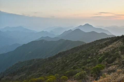
▼ The view from the top of Huangmaojian Mountain is wide


▼ At night, the stars at the top are bright and the Milky Way is clearly visible.

▼ Standing on Huangmaojian in the morning light the next day and looking into the distance


DAY 2
Huangmaojian—Datiantang—Nanxi Village—Chamuyu Forest Farm
About 11h
Overnight at Chamuyu Forest Farm
After watching the sunrise in the morning, we broke camp and set off at 8 o'clock. From the beginning of today, we basically followed the ups and downs along the ridge, with a wide view. However, the distance was long and the climb was large. This day's journey was a test.
Ten minutes later, we passed Huangmaojian South Peak, then entered the woods and began a continuous descent to Fengyang Lake Scenic Area. Fengyang Lake is a Tianchi at an altitude of about 1,400 meters. There are alpine meadows around Tianchi. After walking a gentler distance, we saw the stone monument at the source of Oujiang River standing beside the stream.
▼ Oujiang River—the largest river in Lishui and Wenzhou, originates from the foothills of Baishanzu Mountain


▼ Walk through the dense forest along the transverse line. The ecology here is well protected, and you can even see white pheasants passing through it.

Gradually we walked out of the forest and reached the fire road. The several-meter-wide fire road was exposed to rocks and soil, with almost no vegetation. The fire road leading to Shaoxiang Rock is extremely steep. You need to be more careful on the steep slope. This section is the most difficult journey this morning. Finally, we reached the top of Incense Rock around 12 o’clock.
▼ The top of Shaoxiangyan is a huge rock with a gentle slope on one end and a cliff on the other.

The view from Shaoxiang Rock is wide and unobstructed on all sides, so there is a lot of mountain wind blowing at noon on a sunny day. After finishing lunch here, we continued towards Tiantang Mountain and Great Paradise.
▼ The fire road extending along the ridge ahead is the distance we are going to walk.

▼ Climb up a section of the fire road in the Great Paradise. The relative height difference is as much as 100 meters, almost straight up and down, like a ladder to heaven.

Passing through Tiantang Mountain and Grand Paradise in turn, the tops of these places are covered with rocks, and you can see many piles of rocks piled up by hikers. After descending sharply from the fire road at the top of Datiantang Mountain, we climbed over another mountain and entered the jungle again. After descending for a while, we came to a stone monument of "The Source of Oujiang River".
▼ View from the top of Grand Paradise Mountain

▼ Depart from Datiantang to Nanxi Village

▼ The stone monument at the source of Oujiang River. From here, turn right and follow the Fengbai Ancient Road towards Nanxi Village.

We finally arrived at Nanxi Village at 4 pm, which was already more than half an hour later than our scheduled time. After replenishing water at Nanxi Village Farmhouse, we took a short rest and continued on our way, trying to reach the campsite before dark.
▼ Nanxi Village, surrounded by mountains, is 1,100 meters above sea level. There are more than a dozen houses, but there are only a few residents. People traveling through Qianba often come here for supplies or accommodation.

▼ As Qingyuan is China’s Shiitake Mushroom City, Shiitake Mushrooms can be found everywhere

After passing Nanxi Village, we entered the dense forest again, climbed up the steep mountain, and finally crossed a fire road. There was a continuous climb of more than 400 meters from Nanxi Village to here. We almost didn’t rest in order to rush for time. This was the most tiring section of the day. .
After crossing the fire road, descend along the stone road to the foot of the mountain. After crossing the stream, enter the cement road. Turn left and walk about another kilometer until you finally reach the Chamuyu Forest Farm. It was already past 6 o'clock at this time, and the sky was almost invisible. Fortunately, we finally reached our destination tonight! This forest farm is a management station of Baishanzu Nature Reserve. Even a few days before the Spring Festival, there were people stationed there. The forest farm staff came to register our information, and we lay down to rest in exhaustion.
DAY 3
Chamuyu Forest Farm—Baishanzu—Baishanzu Scenic Area Gate
About 4.5h
We broke camp at 7:30 in the morning, walked along the road for more than four kilometers, and turned left into the jungle of Baishanzu. As a national nature reserve, the ecological diversity here is very rich. Ancient paths covered with moss, fallen and rotten dead trees, and you can feel the vitality around you when walking in the forest.
▼The watershed between Oujiang River and Minjiang River

▼ The ancient road covered with moss

In about 2 hours, we arrived at an abandoned lookout station on the top of the mountain. We could see a higher mountain not far away, which is Baishanzu. Considering that we need to turn back the same way after reaching the summit of Baishanzu, we unloaded our equipment and walked lightly to climb Baishanzu.
▼ Standing at Baishanzu overlooking the watchtower

▼ The top of Baishanzu Peak, 1856.7 meters above sea level

▼ Viewed from the top of Baishan Zu Peak, surrounded by mountains, it is worthy of being the "ancestor of Baishan Mountains"

From Baishanzu to the management station, there is a steep descent all the way. After passing a forest farm management station, and then walking along the winding mountain road, we gradually enter the scope of the scenic spot.
▼ The scenic tour plank road is built in the valley. Along the plank road, you can enjoy many waterfalls of Baishanzu.

There are almost no tourists in the huge scenic spot, and there is even no one on duty at the gate of the scenic spot. At about 12 noon, we walked out of the gate of the scenic spot, contacted the chartered taxi driver, and took the bus to Qingyuan County. At this point, we finally successfully completed this crossing and fulfilled a wish. Only then did I realize that I was exhausted, especially my hips and calves, and I couldn't move any more - it seemed that the reputation of "the best torturer in East China" was not in vain.
In general, "Qianba" has rich natural landscapes and is representative of the hilly landforms in Zhejiang's Zhongshan Mountains. The route is indeed quite intense, so you need to plan your itinerary accordingly. This time the weather was sunny and the climate was mild, which made hiking much easier. However, it was difficult to see the sea of clouds in this weather, which was also a pity. After completing "Thousand Eights", I went home to prepare for the New Year. I look forward to new scenery in the new year!