Day 25
- August 15, 2020
- Starting point: Ranwu Lake
- Destination: Kangyuan Holiday Hotel, Mangkang County, Qamdo, Tibet
- Main attractions: Wild scenery on National Highway 318 (Nujiang River Gorge, Qi Erguai, Yela Mountain, Dongda Mountain, Jueba Mountain, Lancang River Gorge)
- Height: The accommodation site is 3868 meters above sea level, and the highest point is the Dongda Mountain Pass at 5130 meters.
- Weather: Cloudy to overcast to heavy rain
This spring we went to Tibet to see the peach blossoms, and we also stayed at the Ranwu Lake International Self-Driving RV Campground. At that time, because the epidemic had just come to an end and the hotel had not yet fully opened, there was only one type of room provided - containers.
Living in a container that night, I experienced the extreme cold of Ranwu Lake and couldn't sleep well all night (if you are interested, you can read this official article).
When I booked the hotel this time, I repeatedly confirmed that it was not a container room. Although it is summer, I still dare not make mistakes.
Fortunately, the room wasn't cold last night and I slept fairly well.
When we got up in the morning, as usual, we first went to the lake for a walk.
Although the lake water this year is clearer than last summer, it is still turbid and yellow-green. It's much uglier than in spring.
I asked the locals and everyone said that winter is the most beautiful season in Ranwu Lake.
winter? Forget it, it's too cold. It seems that in recent years, we have no courage to see the beauty of Ranwu Lake.
Regarding today’s route, my original plan was to take Bingchacha – a route I had been thinking about for several years. However, there has been continuous rainfall in Linzhi area recently, and it is still impossible to get a definite answer as to whether Bingchacha is accessible or not.
Until 11 o'clock last night - when the deadline I set for myself came - I still didn't get any clear answer.
I asked Lao Chen, the owner of Bingchacha's "cross-country crossing base" - Sichuan Hotel, but there was no reply; I asked about the local hotel in Chayu, but I didn't get a timely reply; I found two posts on Weibo The bloggers of Bingchacha photos, judging from their Weibo posts in the past two days, it seems that they traveled through Bingchacha without success. I asked both of them about the road conditions, but did not get a timely reply...
There are various signs that Bingchacha is in danger.
To ensure safety, I decided to take National Highway 318 to Mangkang, and then take National Highway 214 to leave Tibet from Yunnan. Choosing the Yunnan-Tibet line to go out of Tibet means that this section of the road has not been traveled; secondly, the 318 National Highway has been raining continuously in recent days, and the possibility of landslides and mudslides is very high.
So at 11:30 last night, I booked a hotel in Mangkang and decisively gave up on Bingchacha.
At 9:30 in the morning, we carefully collected all the room cards and checked out (in the spring, we were detained for 200 oceans because we lost 2 room cards). After that, we drove towards Mangkang.
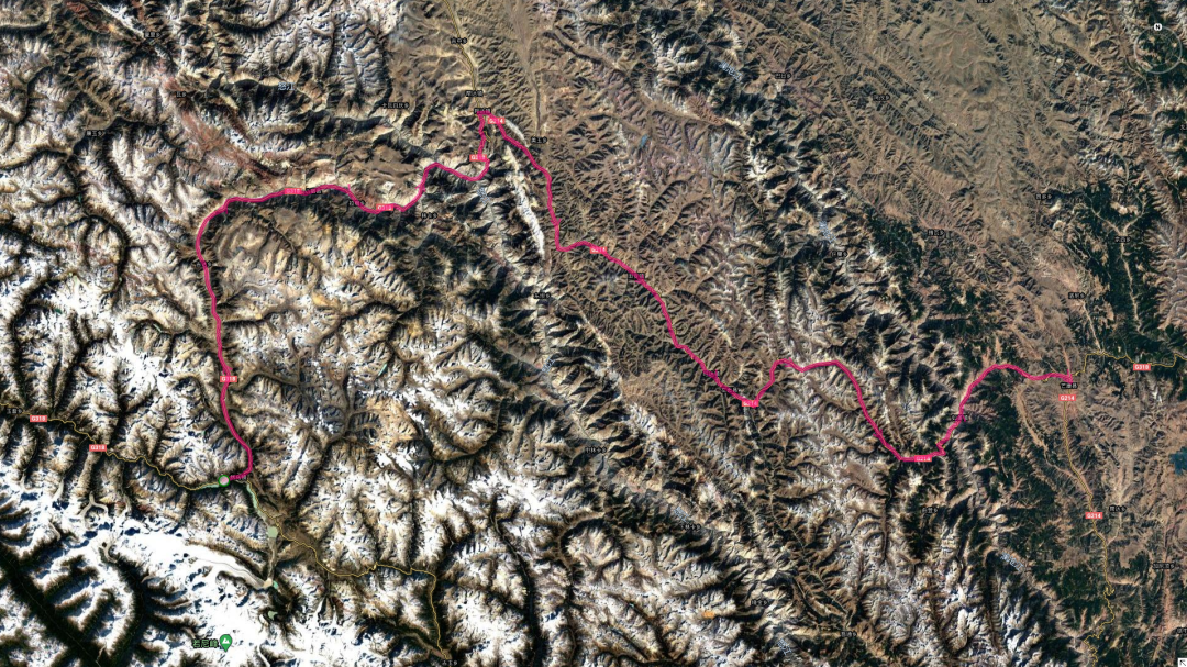
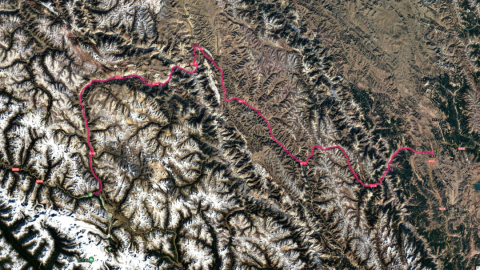
This is today's trajectory

The trajectory on the way is to take National Highway 318 to Mangkang, and the red line is the direction to Chayu

Although Ranwuhu is a bit ugly, since she lives here, I still want to take a photo of her that makes her want to delete it.

After coming out of Ranwu Lake, head all the way north. After walking for an hour, we came to the blue circle. The scenery here is not bad. We plan to "shoot wildly" for the camera.


A stream flows in the valley ahead, and smoke rises from the village

The highland barley next to it has matured and is waiting to be harvested.

After staying for a few minutes, we continued forward to the Nu River Bridge (blue circle). In fact, the road from Ranwu Lake to Mangkang is quite dangerous. Coming out of Ranwu Lake and heading north, you will first enter a section of "Mingdong". The so-called open cave is a building made of reinforced concrete that is "covered" on the highway. It is mainly used to prevent landslides and rockfalls. The tops of these buildings were already filled with fallen rocks. If it weren't for this open hole, I don't know how many cars would have suffered. After that, we walked in the high mountain canyon until we reached the Nujiang Bridge. The road here is winding and narrow, the mountain is vertically steep, and rocks fell constantly on the road (last year I was "lucky" to be hit by a falling rock here). After passing the Nujiang Bridge, there is the Nujiang Gorge and the Seventy-Two Turns. Then there are the winding trails in Dongda Mountain and Jueba Mountain... In short, this section of the road today is quite dangerous. Of course, the advantage is that the landforms along the way are varied and the scenery is rich and pleasant. It is far from comparable to the section from Linzhi to Bomi.


We knew that due to the road conditions on this section of the road, many places were unable to stop and enjoy the scenery, so we did not hesitate to stop and take photos at places where the road conditions were relatively good and the scenery was not bad.

There are actually residents on this seemingly barren mountain.


The colors of the mountains are also richer


Finally crossed the Nujiang Bridge and arrived at the Nujiang Gorge


The rushing Nu River

Who can give me a title?

As a competent photographer, a SLR phone must be used together; as a competent photographer, when everyone is getting in the car and about to leave, they have to take a picture secretly.

After leaving the Nujiang Bridge and walking along the Nujiang Gorge for a while, we came to the 72nd Turn of the Nujiang River. The previous two times we walked from top to bottom, all the way downhill; this time we walked from bottom to top, climbing from an altitude of 2900 meters to 4300 meters in a short distance of 27 kilometers. It was really hard on my right leg.

I took photos at this observation deck the first two times, and there doesn’t seem to be much difference between spring and summer. This time, I plan to fly and see

Flying to 100 meters, this perspective seems to be similar to standing on the side of the road and shooting with a wide-angle lens.


The advantage of an airplane is that it can fly farther and see it from different angles

You can also take selfies. Well, that's me holding the aircraft controller.

Not long after leaving 72guai, as you expected, we came to Yela Mountain

Since it was my third time to come to Yela Mountain, I didn’t take many photos. I just took a picture of a cow in a daze on the roadside.

Since it was my third time to visit Yela Mountain, I didn’t take many photos, so I just took a picture of the mountain next to it. It’s been a year, but nothing has changed in this Tianmen.


Since it was my third time to come to Yela Mountain, I didn’t take many photos, so I just took a picture of the valley in the distance. In spring, I took a snowy photo here, which was hailed as a "blockbuster" by everyone.

After coming down from the mountain, everyone was hungry, so we drove to a gentle hillside and started cooking.

While waiting for the rice to be cooked, everyone was studying the "cow dung" wall of the Tibetan house next to it.


I also took advantage of the rice to cook and took a few random photos.

After eating a good meal, putting away the garbage, and preparing to leave, a group of horses walked carelessly from not far away.

This couple is a perfect match. The man is so handsome and the woman is so beautiful.

After eating, we continued on to a long stretch of flat road with little elevation change (the river valley in the photo just now). After walking out of the valley, we climbed all the way up the mountain, heading towards the Dongda Mountain Pass (blue circle), the highest point of National Highway 318. After arriving at Dongda Mountain, they all went to check in, but I was too lazy to get off the car.

After leaving Dongda Mountain, we headed towards Jueba Mountain. Although the altitude of Jueba Mountain is not high, it is extremely steep and the mountain road is narrow and winding. The Lancang River Canyon on the east side of the mountain is an abyss. My second aunt rated this as the most dangerous road on the Sichuan-Tibet line. Although I don't think it's very dangerous, judging from the bridges and tunnels under construction there, the road administration department at least thinks it is very dangerous. After the tunnel and bridge are opened to traffic, National Highway 318 will lose a lot of fun.


After coming down from Dongda Mountain, we decided to take a rest by the river, so I tried my old trick of taming the river again.


Standing on the top of Jueba Mountain and looking at the valley in the distance

These three people didn't seem scared at all

The mountains in the distance are quite colorful

After leaving Jueba Mountain, we went down the mountain along the only remaining bad road of National Highway 318. Soon we came to a place where we could see the magnificent S-bend of Lancang River from a distance. Fortunately, there was a relatively spacious road bed at the blue circle, and we quickly stopped the car. I walked this section of the road twice in the past. I wanted to take pictures of the Lancang River Gorge but couldn't find a place to park. This time, did this parking spot grow on my own?

The sexy S-curve of Lancang River


Unlike the Nu River, the color of the Lancang River is very bright red, which is probably related to the red soil in Mangkang

After leaving the S bend and continuing forward, you will reach Rumei Town. There is a Lancang River Bridge here. We took pictures on the bridge this spring and my sister's wig almost blew off.


Continue to stand on the bridge and take a few pictures. Fortunately, it's not windy today and my wig is still intact.

It was already 7pm when we left Rumei Town, and we still had 47KM to go. In order to have a good meal, we decided to drive on without stopping. As a result, not long after we started, it started to rain heavily. It seems that God is trying to help us strengthen our will. As soon as it rains, the sky immediately becomes dark. Along the way, we were driving on a winding mountain road. Once, my right front wheel almost slipped into a ditch on the side of the road, scaring everyone into a cold sweat. So I quickly lowered my speed and cheered up, and then I arrived at Mangkang smoothly.