10month15day
Crossing the Dangjin Pass
Early in the morning, it's still dark. Departing from Dunhuang, we will go to Delingha in Qinghai today, visiting several scenic spots on the way, covering a journey of more than 900 kilometers.

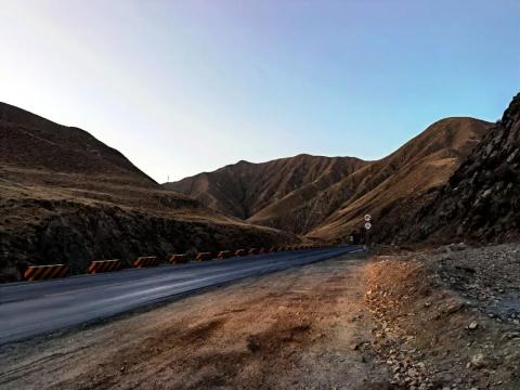
After driving 140 kilometers, at a mountain pass, there was a small open space on the roadside with a low wall, and the car stopped.
The driver Xiao Peng said that this is the Dangjin Mountain Pass. When Jinshan is 3800 meters above sea level, here it is probably 3600 meters above sea level. There is a long way to go and there is no convenient place. If you need convenience, you can solve it here.
After getting off the car, a chill hit the mountain pass 3600 many meters away, making people shiver. Both sides of the road are lined with tall ocher-brown steep rocks, and there are no scattered green plants.
Dangjin Mountain is located at the junction of Gansu, Qinghai and Xinjiang provinces (regions), with the main peak 3800 meters. In the past, it was a place that was inaccessible to people and where birds did not stay. After crossing the Dangjin Mountain Pass, you enter Qinghai and Qaidam Basin, the cornucopia of Qinghai.
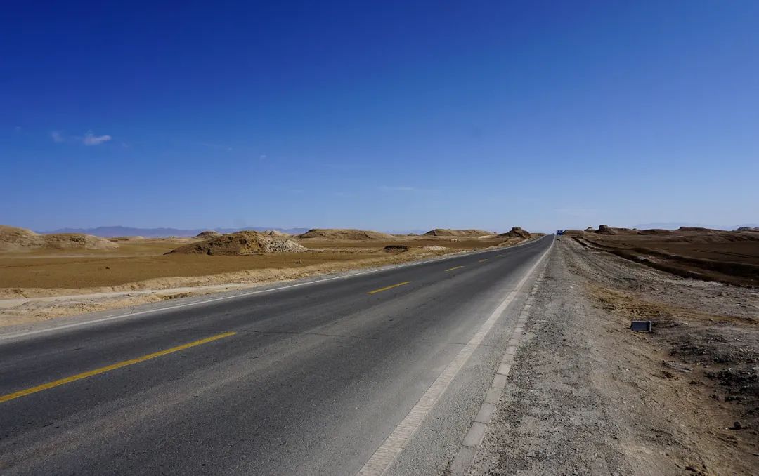
Maybe it was still early in the morning, but there were almost no cars on this road.


The mountains and fields on the plateau are surrounded by such tranquility. The roads are smooth and without potholes. Our car slides quickly through the mountains, with only the mountains and tall iron towers accompanying us. Although the sky was bright, the sun did not appear.
Suddenly, some gold flashed outside the car window. Looking carefully, behind a row of high mountains on the right, there was a peak protruding from the peaks, which seemed to be plated with gold. Oh, the sun is out, and the golden color is painted by the light of the rising sun. This golden luster is slightly darker, and the sunlight seems to have been absorbed by the brown rocks, making it look a bit simple and unpretentious, although it is not as spectacular and breathtaking as the sun shining on the top of the snow-capped mountains, which is like the "Sunshine Golden Dome". The breathtaking landscape, seeing such a scene on this plateau, was enough to make me excited for a while. My eyes were staring out the car window, and the camera was capturing the wonderful scenes that flashed by.


A mountain peak, a row of peaks, a touch of golden light, a piece of gold, the car is moving forward, the sun is rising, and as the sunlight gradually covers the earth, the sight in front of you suddenly opens up. After crossing the mountain pass, the car drove out of the mountain and went down the slope. In front of it was a straight road with no end in sight.

The surrounding mountains are gradually getting further away, and the Qaidam Basin welcomes our arrival with its vastness.
The "Eight Southern Immortals" in the Qaidam Basin
I remember when I was in elementary school, the senior geography textbooks talked about China’s four major basins: the Tarim Basin, the Junggar Basin, the Qaidam Basin and the Sichuan Basin. The Qaidam Basin is rich in mineral resources, especially the beautiful salt lake, which left a deep impression on me. It is still fresh in my mind when I think of it. Today, I finally came to Qaidam Basin, and I was very excited.


However, the "treasure pot" that appeared in front of us seemed to be the desolate desert Gobi.
"Qaidam" is Mongolian, meaning "vast". Perhaps because there are many salt lakes here, some scholars later translated it as "salt lake". The Qaidam Basin, with an altitude ranging from 2600 meters to 3000 meters, has mostly arid desert natural landscapes due to geological formation and climate effects. Looking around, there are few people and the surface is deserted. However, the beautiful Qinghai has its unique beauty waiting for us to see it.


Our car drove through the Gobi Desert and went to the "Southern Eight Immortals Yadan", which is also a must-visit place for the Grand Ring Tour.


"Yadan" is a geological name for a landform. "Yadan Landform" is a typical wind-eroded landform. The ground formed by earthy sediments from rivers and lakes has undergone weathering, intermittent water erosion and wind erosion to form wind-eroded mounds and wind-eroded mounds arranged alternately in parallel to the prevailing wind direction. Depression (trough) landform combination. According to the information: From 1899 to 1903, Swedish explorer Sven Hedin visited Lop Nur, Xinjiang, China. He discovered clusters around the ancient lake, which were several hundred meters long and more than 2-3 meters high. From the northeast to the southwest, the landforms of various shapes formed by water erosion and then wind erosion are called Yardang (originally meaning "hill with steep walls") according to the local Uyghur language. Later, as his book "Central Asia and Tibet" spread widely in academic circles at home and abroad, it was transliterated as "Yadan" in China. Since then, the term "Yadan" has been officially accepted by the scientific field.
Legend has it that whenever the wind blows at night, and in this landform group will make sounds that sound like the devil in mythology. Therefore, people also call this landform group the "Devil City" .


Among the Yadan landform groups, the Yadan landform group in the west of the Qaidam Basin is the longest extending Yadan landform in the world. "Nanbaxian Yadan" is located on the northwest edge of the Qaidam Basin. This is a large no-man's land. The small mounds of high and low can be described as strange. People call this Yadan landform the "Eight Immortals of the South" because there is a magnificent and touching story.
In 1955, the first batch of developers were welcomed here, and they wanted to bring life to this ancient and desolate place. Among the developers, there are eight female geological team members from the south. They settled here in search of oil, carried out work, and spent their youth and sweat. During a field exploration, eight female team members got lost on their way back and sacrificed their young lives for the construction of the motherland and the development of the Northwest. In order to commemorate them, people named this place "Southern Eight Immortals".
Now, although there is a highway passing through "Southern Eight Immortals Yadan", the terrain is complicated and the communication signal is not good. When traveling here with a group, the tour guide will remind you not to leave the highway too far, otherwise it will be troublesome if you get lost. Everyone who travels by car knows that they don’t dare to take too many risks in this place and drive too far.

The car stopped in an open area on the side of the road. When I got off the car, I saw that there was no end to the straight road. There are several mounds more than ten meters high on both sides of the road. When you climb to the top, you will see a vast desert with countless mounds on it. Some of these mounds have similar shapes, like an array; some have different shapes and are scattered scattered. The ground is yellow and not a blade of grass grows. If it weren't for the long strip of highway and the cars on it, it would have been like drifting to an alien planet.
Standing on the top of the mound, I naturally felt emotional again. The creative ability of nature is unimaginable.