Arriving at Erdaobaihe, I rested in the town for two days and prepared to enter the core scenic area and go to the top of the main peak of Changbai to see Tianchi. Today is September 9th. The local temperature ranges from -1 to 17 degrees and the air quality is excellent.
Changbai Mountain refers to the entire Changbai Mountains, which is the general name for the eastern mountains in East Asia. It starts from the northern foothills of the Hulin Wanda Mountains in Jixi, Heilongjiang in the north, extends to Laotieshan in the Qianshan Mountains in Dalian, Liaoning in the south, starts from Hadal Ridge in Jilin in the west, and reaches the Korean Peninsula in the east. It is composed of multiple northeast-southwest parallel mountain ranges, basins and valleys, covering an area of approximately 310,000 square kilometers. It is about 1,300 kilometers long and 400 kilometers wide from east to west, and is slightly spindle-shaped.

The Changbai Mountain we are going to today refers to the main peak area of the Changbai Mountains. There is a volcanic cone (Tianchi) surrounded by 21 peaks such as Baitou Peak with an altitude of 2760 meters, the lava plateau around it, and the ridges composed of many surrounding mountain systems. . Changbai Mountain is a giant compound dormant volcano with an irregular oval shape on the outside, with a long axis of about 140 kilometers and a short axis of about 120 kilometers, extending from the northeast.

The main peak area of Changbai Mountain is under the jurisdiction of the Changbai Mountain Protection and Development Zone Management Committee of Jilin Province, which has three scenic area management committees: the northern slope of Tianchi is Chibei District, and in Erdaobaihe Town, Antu County, the Changbai Mountain Protection and Development Zone Management Committee also Located here; Manjiang Town, Fusong County on the south slope is Chinan District; Songjianghe Town, Changbai County, on the west slope is Chixi District. The main peak of Changbai Mountain also has an east slope, which is located in North Korea and belongs to Samjiyuan County, Yanggang Province, North Korea. It was demarcated later.

Changbai Mountain Tianchi Scenic Area has many famous attractions: Divine Beast Tianchi, Golden Toad Crouching Peak, Changbai Waterfall, Ambergris Hot Spring, Ice Valley Grand Canyon, Green Water Pond, Xiao Tianchi, Underground Forest, Underground River, Pumice Forest, Ice Shuihan Spring, Erdaobai River Migratory Birds, Meirensong Park, Hetu Luoshu Cultural Park, etc.

01
The history of Changbai Mountain
On the morning of the third day after arriving at Erdaobaihe, Chen Ping and I were preparing to enter the 5A scenic spot. Chen Ping saw an online introduction saying that she had to go out at around six o'clock in the morning and come back at around seven o'clock in the evening. So we got ready early and looked forward to climbing up Changbai Mountain to see Tianchi.

Changbai Mountain is the highest mountain system on the eastern edge of the Eurasian continent. It is located in the southeast of Jilin Province and adjacent to North Korea. It is named for its main peak with white pumice and snow. It is the birthplace of the Manchus in China and the holy mountain of Manchu culture. It is also an ancient volcano. Its rich resources have nurtured the primitive peoples of Northeast China and nurtured Northeastern culture. It is known as the "No. 1 Mountain in Guandong".

Changbai Mountain has its own establishment. In the Western Han Dynasty, it was under the jurisdiction of "Juli County", in the Eastern Han Dynasty, it was occupied by the "Goguryeo Kingdom", in the Tang Dynasty, it was the settlement of the Mohe Su tribe and the seat of the "Bohai Kingdom" in the Tang Dynasty, and in the Liao Dynasty, it was the "Dongdan Kingdom" In the beginning, it was the separatist territory of the "Ding'an Kingdom" in the Liao and Bohai Seas, and in the "Xingliao Kingdom" in the Liao and Bohai Seas. In the Jin Dynasty, it was the territory belonging to the Haolan Road, in the late Jin Dynasty, it was the territory of the "East Xia Kingdom", and in the Yuan Dynasty, it was the territory of the Kaiyuan and Liaoyang 2nd Roads. Ming Dynasty was divided into three areas.

At the end of the Yuan Dynasty and the beginning of the Qing Dynasty, the Changbai Mountain area was banned as a dragon vein. Later, due to the epidemic in the Central Plains, there was an upsurge of people from the Central Plains and Shandong entering the Guandong region in the late Qing Dynasty. The Korean Peninsula also saw an increase in the population coming from the Korean Peninsula due to famine and forced immigration by Japan. The Qing Dynasty established Antu and Fusong counties in 1909, which governed Changbai Mountain and were under the jurisdiction of Changbai Prefecture in Fengtian Province. The main peak of Changbai Mountain and Tianchi area are mainly concentrated in the two counties of Antu and Fusong. During the Japanese occupation, Antu County was placed under the jurisdiction of the Jiandao Province of the Puppet Manchu Empire.

After the founding of New China, the Ministry of Public Security established the Changbai Mountain Forest Public Security Team. In April 1960, the "Jilin Province Changbai Mountain Nature Reserve" was established, and later the Jilin Province Changbai Mountain Nature Reserve Management Bureau was established, under the direct leadership of the Provincial Forestry Department. In July 1986, the Ministry of Forestry submitted a request to the State Council for approval, and Changbai Mountain Nature Reserve was listed as a national forest and wildlife nature reserve.

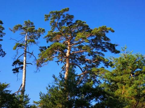
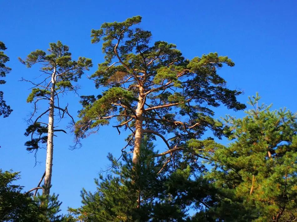
In 2005, Jilin Province established the Changbai Mountain Management Committee, which was upgraded to the department level in 2006. The Provincial Forestry Department entrusted the Changbai Mountain Management Committee with the reorganization of the Changbai Mountain Protection Bureau. (The picture below shows the famous "Beauty Pine" in Changbai Mountain)

The Changbai Mountain area has a total area of 196,400 hectares, with a core area of 75,800 hectares. The highest peak of the Changbai Mountain system is General Peak (formerly known as Baekdu Peak) in North Korea, with an altitude of 2,749 meters. Baiyun Peak, the highest peak in China, is 2,691 meters above sea level and is the highest peak in Northeast China.

There is a crater lake on the top of the volcanic cone - Tianchi, which is the highest and deepest lake in Northeast my country. The crater walls around Tianchi are steep and form 21 ring-shaped mountain peaks, all with an altitude of more than 2,500 meters. There is a road on the north slope that reaches the top of the mountain, overlooking Tianchi.

Changbai Mountain is one of the first batches to enter the "National Natural and Cultural Dual Heritage Preparatory List", one of the first batch of national nature reserves, the first batch of national 5A tourist attractions, the United Nations "Man and the Biosphere" nature reserve and an international A-level nature reserve. The world-famous "Species Gene Bank" and "Museum of Nature". Changbai Mountain and its Tianchi, waterfalls, snow sculptures, forest seas, etc. have been selected into the "Guinness" world record for many times. It is also known as one of the top ten famous mountains in China, the five most beautiful lakes in China, and the top ten most beautiful forests in China.

The average altitude of Erdaobaihe where we stayed is 800 meters, and the climate is cold in winter and cool in summer. From the foot of the mountain to the top of the mountain, Changbai Mountain has four vertical landscape zones: coniferous and broad mixed forest, coniferous forest landscape, alpine birch forest, and alpine tundra. There are 1,558 species of wild animals and 2,008 species of various plants.

In 1979, Professor Poole of UNESCO visited Changbai Mountain and said: A well-preserved forest ecosystem like Changbai Mountain is rare in the world. She is a valuable asset not only to the Chinese people, but also to the people of the world.

Wu Zhaoqian of the Qing Dynasty wrote a poem about Changbai Mountain:
Changbaixiong is in the northeast, and Saga overlooks Saizhou.
Far away from the dawn of the sea, standing alone in the wild autumn.
White snow spreads across thousands of mountains, and the blue sky pours down.
If Dengfeng can be done, he should wait for Cuihua Tour.

We drove to distant places and traveled around the country. We felt that Changbai Mountain indeed has beautiful scenery, pleasant climate, rich local specialties, and standardized scenic management. It is a rare summer resort worth visiting again.

02
Ride to Changbai Mountain Tianchi
Go to the tourist transfer center and park the car next to the Hetu Luoshu Cultural Park where we visited yesterday.

Take a bus from the transfer center to the gate of the scenic spot and it costs 20 yuan per person for a round trip. At the foot of Tianchi Mountain in Changbai Mountain, there is a transfer center up the mountain. The transportation fee for this more than 20 kilometers is 85 yuan, which is a bit expensive!

Take the minibus dedicated to the scenic area and circle up the mountain to the top of the mountain with an altitude of more than 2,500 meters. The transportation fee for this mountain climbing road is 80 yuan, and the entrance fee is 125 yuan.

I rode at the front on the minibus and had a very good view when going up the mountain. The traffic in the scenic area was in order and every car consciously kept to the right in its own lane. Although the climbing roads in Changbai Mountain are rugged, tourists are comfortable riding due to good management. ,Safety.

Starting from Erdaobaihe, which is only 800 meters above sea level, the team meandered all the way up the hill. At 2,300 meters, we could still see that there was no forest on the roadside, and only some moss grew on the hillside.

Looking back at the bottom of the mountain, there is a green onion. Before I knew it, I was above the clouds.

Insert video: Ride to the Long Daytime Pond

It was almost 12 o'clock when we got off the bus at the Beipo Management Station beside Tianchi Lake. It felt very cold after getting off the car. It snowed heavily two days ago, and the wind was howling and it was biting.

Ice had already formed on the windowsills of the wooden houses, and the eaves were hanging down with ice. We were curious.

Although there is ice and snow around the high-altitude Tianchi, the crowds of climbers are bustling and lively, which dilutes the cold feeling.

I saw tourists all around wearing cotton coats or down jackets. There are no trees or turf on the hillside, only white snow covering the tops of the mountains around Tianchi. On the road we walked, there was unmelted ice and snow, which made a clicking sound when we stepped on it. The whole scenery was like winter. This gave us southerners a strange feeling that winter had entered early in early September.

Tianchi is just east of the mountaintop management office, and a wooden plank road leads to the edge of Tianchi. Together with the tourists, we walked carefully on the slippery ice and snow.

Beside Tianchi is the "Tianchi" stone tablet inscribed by Deng Xiaoping, who visited here in the summer of 1983.

The railings by the pool have been crowded with tourists for a long time. Fortunately, the temperature is too low. The tourists who come in front will take photos and watch for a short time before they freeze and leave automatically, and they will be replaced by the tourists who come after us. Noon is the peak time for tourists, and in the afternoon there are not many people.

Tianchi is surrounded by cliffs. Visitors may be squeezed out of Tianchi if they are not careful. Therefore, the scenic area has laid strong steel bars and steel wire ropes around Tianchi for safety precautions. In dangerous places, there are security personnel wearing red armbands reminding and persuading tourists to pay attention to safety and not to exceed the safety rope. I saw a young man wearing a coat and sunglasses whose eyes were darkened by ultraviolet rays. He tied his body to a steel railing and stood on the edge of the cliff, facing tourists. As long as someone exceeded the rope slightly, he would endanger his own safety. Regardless, do your duty quickly and dissuade people from crossing the line.

They also took out the beautiful scenery of Tianchi they took during their spare time and proudly showed it to tourists.

03
Tianchi, a backdrop of white snow and blue waves
The circle of people surrounding Tianchi retreated, and it was our turn to approach Tianchi. Touching the railing with our hands, we were finally able to overlook the blue water at close range. We were a little excited.

Changbai Mountain was formed by the geological orogeny 12 million years ago. Tianchi is located at the top of the volcanic cone of the main peak of Changbai Mountain. It is a crater that accumulated water over time and became a lake. Changbai Mountain Tianchi is 2189.1 meters above sea level, 4.4 kilometers long from north to south, and 3.37 kilometers wide from east to west. The water surface area is 9.82 square kilometers, the water surface circumference is 13.1 kilometers, the average water depth is 204 meters, and the deepest reaches 373 meters.

Insert video: We saw the beautiful long day pool

According to local people, midsummer is the best time to view Tianchi. There are relatively few clouds and fog, so there is a greater chance of seeing the true beauty of Tianchi. The sea of clouds is hazy and illusory, beautiful and moving. It often appears on the top of the mountain in the midsummer morning. Looking at the bottom of the mountain, there is a sea of clouds and undulating waves. Looking at the mountains, there are surging winds and endless clouds. Sometimes during the day, the sky is clear on the mountain. Looking down the mountain, there are patches of white sails, reflecting the distant forest sea.

Tianchi has more than 270 windy days throughout the year, with an average wind speed of 11.7 meters/second, making it a huge wind outlet. The top of Changbai Mountain has 179 foggy days throughout the year, the highest in the country.

The Chinese tourists who come up from the north slope are very religious and regard going to Tianchi as a major event in their lives. They say that if you can see Tianchi once, you will be lucky in your life. If you don’t see it the first time, you will come again, or even a third time. On the bus, we met the couple who were coming for the third time. We were lucky. The first time we came up, the sun was shining brightly on the top of the mountain and the whole view of Tianchi was displayed in front of us. It seemed that our next journey would be smooth. Of course, when we were still in Hunchun, we were optimistic about the weather forecast and counted the days to come to Tianchi.

Since the main peak of Changbai Mountain is close to the Sea of Japan and the Yellow Sea of China, it has abundant rainfall. Many unique rivers, waterfalls, hot springs, mineral springs and lakes have developed on the volcanic cones and lava plateaus of Changbai Mountain. There is a narrow channel between Tianhuo Peak and Longmen Peak, from which the water overflows and flows through the Chengcha River, which is 20 to 30 meters wide and 1.5 kilometers long. It falls from the cliff with a height of 68 meters and falls into a white waterfall. Note: Erdaobai River, which flows all year round, is the main source of the Songhua River. The Tumen River and Yalu River originate from the east slope and west slope respectively.

Changbai volcano is in a dormant period, but there are still many hot springs overflowing from the ground on the slopes of the main peak, indicating that there is still huge energy underground. According to modern earthquake observations, the crust in the Changbai Mountains is relatively stable and there are no signs of volcanic eruptions.

The main peak of Changbai Mountain has a vertical height of more than 2,000 meters. The vertical climate is divided into mid-temperate zone, cold temperate zone and alpine sub-arctic zone; winter is long and cold, summer is short and cool, and spring and autumn are long.

Vegetation types in Changbai Mountain are also distributed vertically. Below 550 meters on the north slope is the Mongolian oak forest; below 1100 meters is the Korean pine broad-leaved mixed forest belt; from 1100 meters to 1700 meters is the spruce fir (dark coniferous forest) forest belt; from 1700 meters to 2000 meters is the subalpine birch forest belt; 2000 Meters above 100 meters all the way to the top of the mountain is the alpine tundra zone.

The Changbai Mountain Area adopts the Chinese Academy of Sciences’ daily average temperature classification method for four seasons. That is, the daily average temperature is 0-18℃ as spring and autumn, 18℃ or above is summer, and 0℃ or below is winter. Spring at the foot of the mountain is from late March to late June; summer is from late June to late August; autumn is from late August to late October; and winter is from early November to late March.

It is said that there are cultural monuments around Tianchi such as the Tianchi Stone Pile, the Bagua Temple and the Jurchen Altar. We followed Zhongba down the mountain and did not have time to see them.

04
The legendary long daytime pool monster
Tianchi freezes in late November every year and thaws in mid-June of the following year. The freezing period is 243 days, and the ice thickness is 1.25 meters. It is said that the maximum ice thickness was 3 meters in 1930, and the snow on the ice was 1 meter deep. In addition, under the cliffs of Baiyun Peak, Huagai Peak and Jiangjun Peak, the lake water is not frozen in winter due to the influence of the hot springs at the bottom of the lake. During the thawing period from mid-June to mid-October every year, the waves on the lake surface can exceed 1 meter when the wind is level 5, and the lake water is like a mirror when there is no wind. In such an environment, there are endless rumors of water monsters in the lake.

There are several versions of the theory that there are water monsters in Changbai Lake.
First, there seems to be ancient mythical beasts in Tianchi. It is recorded in the Qing Dynasty's "Changbai Mountain Jianggang Zhilue": "A monster emerged from the water in Tianchi. It was golden yellow, with a head as big as a basin, a square top with horns, a long neck and many beards. The hunter thought it was a dragon.”

Second, one noon in August 1976, by the deep blue Tianchi Lake under Tianwen Peak, a group of tourists from Beijing, China, were sitting on the ground and having a picnic. Suddenly, a girl let out a sharp scream: "Look, water monster!..." Everyone looked back in shock and saw a ferocious water monster with dark fur, like a brown bear, lying on a piece of land beside Tianchi. Behind the jagged and strange rocks, his eyes were glaring at the crowd nearby. When it heard the scream, it jumped up in horror, jumped into the water with a splash. A herringbone ripple suddenly surged in the calm Tianchi, and the water monster disappeared instantly. Many witnesses unanimously confirmed this fact? Is this an otter that came upstream from the Chengcha River? unknown.

There are no primitive fish inhabiting Tianchi. In 1988, North Korea tried to throw red trout seedlings into the lake. Every spring, they can occasionally be picked up at the foot of the waterfall, but the individuals are not large.

Third, from August 21st to 23rd, 1980, Tianchi experienced rare sunny skies in the mornings for three consecutive days. In the morning, Chinese writer Lei Jia and other six people discovered a water monster in the middle of Tianchi. Looking from a distance, sometimes a basin-sized black spot was revealed, shaped like a head, and sometimes a long spindle-shaped body was revealed, shaped like a ridge. It circled back and forth in the water and then disappeared. The next morning, five or six water monsters appeared on the lake in the distance again, and it took about 40 minutes to dive into the water one after another. At 8:30 a.m. on the third day, someone spotted two water monsters emerging from the water. They first looked at the witness, then turned around and swam toward the center of the lake one after another until they dived one after another four to five hundred meters away from the shore. , which lasted about 10 minutes. A comrade at the Tianchi weather station refused to give up and waited patiently. More than an hour later, he saw a huge head, a neck more than 1 meter long and part of the chest exposed on the water forty to fifty meters in front. He clearly saw that the water monster had dark brown hair, a white ring under its neck, about 5 cm to 7 cm wide, and round eyes as big as a table tennis ball. Seeing the water monster swimming towards him, he panicked and quickly raised the gun he brought to aim. At this time, the water monster suddenly turned around and swam toward the center of the lake. There were two gunshots, but it didn't care at all. It swam a certain distance and then dived into the water.

Fourth, on June 17, 1981, strange animals were discovered again in Tianchi. At noon that day, Li Changyou, director of the Hengshan Police Station in the Changbai Mountain Reserve, and five other people were taking photos above. Suddenly, someone pointed at a blue water strip in the Tianchi and shouted: "Look, a white thing is coming out!" Following the sound, a white thing appeared. The spots are particularly eye-catching in the blue lake water. Through the telescope, I found that this is a water monster about two meters long. The head is big and round like a leopard's head. Except for the forehead and top of the head, which are pure white, the rest of the visible part of the body is egg yellow. , its body is slender, and the body floating on the water is shaped like an anchovy. It drags a tail and is floating on the water, as if basking in the sun. Six people took turns observing the water monster with binoculars and saw it swimming in the water and crawling onto the ice for a while.

Fifth: There is also a saying that it is an ocean "sunfish". Tianchi in Changbai Mountain is an active volcano and is close to the Sea of Japan. It is very likely that there is a tunnel leading to the Sea of Japan, so the sunfish enters Tianchi through the tunnel. Tianchi in Changbai Mountain is an active volcano. There is volcanic activity deep in the lake bottom, which is rich in minerals and provides food for sunfish. At the same time, volcanic activity makes the lake water warm, so it is suitable for sunfish to survive. In addition, the water monster has the habit of spinning and jumping out of the water, which is very similar to the sunfish. This statement is rather bizarre.

Sixth, some people believe that the rocks in Tianchi that often appear and disappear are like animals, sometimes emerging from the water and sometimes sinking into the water. There are also large pieces of pumice ejected from the volcano, which float in the water and move when the wind blows. From a distance, they look like animals swimming in the water. Perhaps these are the answers to the mystery of the Tianchi water monster.

According to statistics, from 1962 to 1980, a total of more than 20 people witnessed the Tianchi water monster five times. Their descriptions of it were summarized as follows: the head is bigger than a bull's head, the mouth is protruding, the neck is long, and the body is huge (more than 3 meters). .

Tianchi is a crater lake. Its formation history is very short. It is impossible for a new species to form in such a short period of time. The water surface of Tianchi in Changbai Mountain is 2189 meters above sea level. It has 258 snow days per year and a freezing period of 8 months a year. The water temperature is only about 11°C even in midsummer. It is also an alpine lake formed by a volcanic eruption and is surrounded by peaks. There are no fences, vegetation, and a dangerous natural environment. There are very few organic matter and plankton in the water. Only a few types of cold-water fish can survive in the water. Scientists believe that "monsters" cannot exist.

Although there are living creatures found in the Chengcha River below the waterfall, the individuals are not large. How they survive at the top of the biological chain is still a mystery.

05
North Korea calls Changbai Mountain "Baekdu Mountain"
We followed the crowd moving around Tianchi and came to the north of Tianchi to watch. From the top of the mountain, you can clearly see the eastern part of Tianchi. There is a sightseeing trail extending downward from the top of the mountain. This is the sightseeing trail built by Dongpo North Korea to go down to Tianchi Lake.

Although they have built buildings by the lake, the east slope of the neighboring country is deserted. Even though there is a plank road going down to the lake, there are no people. The situation there is in huge contrast with ours on the north slope of Tianchi.

There are 21 peaks surrounding Tianchi, 3 of which are boundary peaks between China and North Korea, and 3 peaks are in North Korea.

It is said that all of Tianchi in Changbai Mountain was originally within Chinese territory. In September 1963, under Kim Il-sung’s repeated requests to “establish a sacred place for the Korean revolution,” the Chinese government and the North Korean government signed a non-public treaty, and China’s national boundary was retreated in the eastern section of Tianchi. Thirty kilometers away, the border turned a corner at Changbai Mountain, and the eastern slope of Tianchi was assigned to their country. Changbai Mountain changed from being unique to China to becoming the boundary mountain between China and North Korea, and Tianchi became the boundary lake. Under the historical circumstances at that time, this was an intimate witness to the friendship between China and North Korea.

Adjacent to Changbai Mountain is North Korea's Samjiyon County. Kim Il Sung's parents lived there before moving to China. It was also the birthplace of Kim Jong Il. This area was where Kim Il Sung and the Northeast Anti-Japanese Alliance fought against the Japanese. At the main battle site, his wife was from Nanyang on the other side of Tumen. North Korea calls SamchiYonjun the holy land and cradle of the Korean revolution.

The map of China published in 1957 clearly shows that Tianchi Lake in Changbai Mountain is entirely within Chinese territory. Even during the Japanese rule of Korea, Tianchi Lake was also on Chinese territory; this was also recognized when North Korea was founded. The day after North Korea took over the land in Changbai Mountain, it called Changbai Mountain "Baektou Mountain" and Baektou Peak was renamed "General Peak" to commemorate Kim Il Sung.

The current situation of Tianchi being owned by two countries can be seen on the map as a corner recessed toward China.

It was too cold on the mountain, it was estimated to be around minus 10 degrees Celsius. We didn’t rent a coat, so we couldn’t bear it anymore. We took transportation down the mountain early to see the hot springs, Tianchi Waterfall, underground forest and other scenic spots on the mountainside.