
Today's itinerary is starting from Jiaju Tibetan Village, passing through the plateau grassland, which is the Tagong Grassland area, and finally arriving at the magical town of Xinduqiao at the entrance of the Sichuan-Tibet Line . Taking into account the little-known temple and the magical Xindu Bridge encountered on the Tagong Grassland Road, today’s travelogue was happily divided into two parts.
Moshi Park is an "Internet celebrity geological landscape park" that has been hailed by Little Red Book and some news. In the past two years, I have hated the word "Internet celebrity" so much that I can't express my feelings about this park. I have a very tangled mentality. But what can I do? My itinerary planner Ah Hao has already reserved the park tickets (and paid for them). My principle has always been not to throw cold water on him when he is diligent. So I can only express my good expectations for Moshi Park obediently.
The interesting thing before departure was meeting a tour group composed (mostly) of my former colleagues from Factory M. They used to live above me, right above me. At midnight the night before, I heard a group of people going back to the room noisily in the B&B room, and it turned out to be them. Their trip went through hardships and dangers that I could never imagine, so when we said goodbye at the B&B, I couldn't help but tell them over and over to be safe.

■ China Panda Avenue
Among the G350 national highways, the V-shaped section of the road that starts from Zhailong Town (near Xiaojin County) in the east and ends in Luhuo County in the west is also named "China Panda Avenue". This is a very heavy name in the eyes of passers-by like us. There is a theory that this avenue got its name because it passes through the Wolong Panda Conservation Base, but in fact Wolong is located on the east side of Xiaojin County. As for how the name came about, I'm afraid I won't be able to find out for a while. However, I personally agree with the praise that this road is an excellent local landscape avenue.

▲ Panoramic view of "China Panda Avenue"

After leaving Jiaju Zangzhai, we quickly entered the G350 national highway, which is also the "Zhongxiong Road". The road conditions were similar to those experienced yesterday. Fortunately, there were not many cars. Everyone was hit by falling rocks or the roadbed was destroyed by water flow. Collapses can be easily avoided. I can't help but think about a problem. Not only in Sichuan, but also in many places at home and abroad, in order to avoid rockfall, some increasingly advanced devices are used to protect the roads and villages at the foot of the mountains. On the highway, we used to feel reassured by the tall metal protective net above our heads, but we were also troubled when we saw that a falling rock that did not seem to be as big as we imagined could knock the protective net upside down and twist it. Chills. In fact, compared to the destructive power of falling rocks, these protective nets, no matter how strong they look, are just a mantis' arm.
Along the way there are the remains of private houses that were hit by falling rocks, and a three-story building whose foundations were washed away by the river and leaning on the roadside, but there are still people living and running shops. If rockfall is a random natural disaster that cannot be avoided in the long term, then why do we still persist in living here at the risk of having our house destroyed by . But on reflection, this was just the arrogant assumption of a passerby who happened to be passing by and could only glimpse the most obvious appearance.
Life here is too far away for me, so far away that it is impossible to construct clues and feelings about living here based on my own life experience. People passing by closed their mouths to take a good look at the scenery, and they were responsible for holding back their gesticulating movements.


Yala Snow Mountain is the birthplace of the Yala River. It is located at the junction of Danba, Kangding, and Daofu. It is nearly 6,000 meters above sea level. Since it is closer to the plateau and plains, it is a snow mountain that is easy to see. It is also a very famous sacred mountain in the local area. Not long ago, Yala Snow Mountain was included in the scenic area by the local area. If you want to get closer to the foot of Yala Snow Mountain, you have to pay to enter the scenic area. From the perspective of protection, it is understandable, and the scenic spot also offers free holiday tickets.
However, as soon as the car entered the parking lot, Ah Hao and I were defeated by the altitude of 3,500 meters. Holding on to the car door, I felt the pain in my skull that was like a drum, and it took a while to calm down. The two rookies looked at each other helplessly across the car, and tacitly gave up the idea of entering the snow-capped mountain scenic area. Fortunately, due to the design of this scenic spot and the exceptionally clear weather today, you can clearly see the peaks of Yala Snow Mountain even while standing in the parking lot. After continuing along the road and turning a corner, there is an observation deck with a better view of the Yala Snow Mountain peaks. After taking advantage, I couldn't help but sigh, "You can see clearly even from a neighbor's house than in the scenic spot."

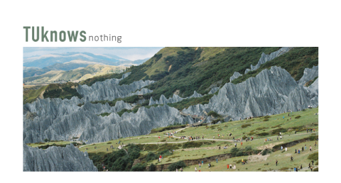
■ Moshi Park
I heard that Moshi Park was originally a geological park that no one cared about. It became extremely popular after it started marketing "Internet Celebrity Photos". My curiosity about Moshi Park stems from what are those black coal mine-like stone forests to curious. The next science popularization may be a bit boring, if does not pass I am even more helpless is that probably the park has already made up its mind to go To be "Internet celebrity attraction ", the science popularization responsibility under the big characters "Geopark " on the signboard becomes one sentence "Daofu Eight Beauties" and one sentence "China Geology Bermuda" hastily summarized. So much so that in order to find the answer, I even dug out the 1987 document .
The stone forest formed by the black rocks here has different names in geology according to different definitions. From the characteristics of the rock mass that makes up the stone forest, it is called "mylonite". The formation of this kind of rock depends on the "Xianshui Fault Zone" that runs through Daofu County. The active fault zone has continuously squeezed and sheared the rock for millions of years or even longer, causing the rock to break and Thickened. Later, due to the uplift of the Qinghai-Tibet Plateau, the mylonite at the junction was exposed on the surface. Due to the erosion of running water, gravity, weathering and other reasons, the cemented and dispersed rock and soil gradually formed today's black stone forest landscape. Mylonite is widely distributed along the Xianshui fault zone in Daofu County and even Luhuo County. However, only the Bamei Town area can form a stone forest landscape.

▲ Shortly after entering the grassland area along the "China Panda Avenue", mylonite mountains can be seen everywhere on the roadside, but they are not stone forest structures.
Therefore, the rarity of Moshi Park is indeed justified. Cars preparing to enter the park parking lot were lined up on the G350 national highway. Fortunately, we had already exchanged our tickets and could drive straight in. This is the most people I have seen since the start of the epidemic this year. There were about 6 or 7 lines lined up in front of the park gate, some queuing up to enter the park and some queuing up to buy tickets. Partly because you have to take the shuttle bus directly after entering the park, the lack of capacity has led to slow entry into the park. Another part of the reason is that most people queue to buy tickets and enter the park at the same time. Lack of guidance from the staff, I don’t know which queue to line up at. I ran back and forth to investigate, and finally ForestryThe armed policeman said "Those who have tickets can enter directly" and pulled us into the express lane and sat in the shuttle bus I turned around and looked at the crowd crowded together, feeling a sense of nervousness and chest tightness.
The shuttle bus drove straight into the back of the mountain, and then we had to walk on an upward trail. The scenic spot is a "one-way street" with the entrance and exit only a few hundred meters apart, but tourists basically don't need to turn back when going from the mountain to the bottom. For a group of tourists who are holding oxygen bottles and ready to breathe oxygen at any time, it can be considered very friendly. From the moment you enter the trail, the landscape of the Moshi Stone Forest gradually appears in front of you. In this season, the mountain meadows are dark green, and the stone forest is not pitch black, but dark gray. Except for the blue sky, everything you see is intertwined gray and green. Even unprocessed photos can record the wonders of the world.


▲ fujifilm X100s original film without color correction
The stone forest is like a bonsai of strange rocks. Due to the unique formation principle of mylonite, the stone forest here is actually soft compared to other rocks. They have completely different shapes. Different shapes can represent different "development stages" of the stone forest: the groove-shaped one is relatively "young", while the sharp-edged one has entered the stage of decline. However, in the eyes of tourists, these are just background. People stood on the ground and kept trying to get closer to it. The dense crowd of tourists are just weak black spots in the eyes at this time. I like this viewing platform very much. Tibetans are shouting at the viewing platform about the experience of riding horses in Tibetan clothes. guests who can’t stand the high fever are sitting there The pavilion is relaxing in the pavilion . The altitude is more than 3,000 meters. Although there are no mountains in the field of vision, we are equivalent to being at the top of a mountain. If it weren’t for the fact that there was only a trail going down the mountain ahead, Ah Hao and I would have retreated again.


▲Fujifilm X100s original film straight out without color correction
After getting close to the stone forest, in addition to seeing the lines and traces on the rocks with the naked eye, you can also enjoy an Internet celebrity photo contest up close. Perhaps it is only unique to the local area but has not been rare enough to be a national treasure. The inkstone rocks can be touched and stepped on. So everyone used their 380 skills, and the geological and natural landscape took on the flavor of a cultural landscape.
Overall, I think Moshi Park is a rough scenic spot. The facilities in the entire park are equivalent to non-existence. In addition to the construction of trails and quite rough recreational facilities such as off-road go-karts in the scenic area, it is also difficult to see staff who come to popularize science or maintain the scenic area (fire prevention personnel on duty). There are quite a few armed police). When I come to Western Sichuan again, I am almost certain that I will never spend a ticket for this scenic spot again. Natural landscapes are the treasures of western Sichuan, and it is understandable to enclose them as scenic spots for protection and management. However, if the land is enclosed but not properly operated, making the troublesome management a stumbling block that hinders the charm of the scenery, it will really harm the scenery. Damn.
■ An easter egg
When writing this article, I have been referring to the online map to confirm the route and place names at that time. I accidentally discovered that we were passing through the Garze area. If we switch the map to terrain mode, the scenery we see is very beautiful. The texture of the earth is recorded very faithfully. In one picture, it looks like the veins of a leaf, but inside it, it looks like daunting mountains. It is so shocking to a person like me who lacks geographical knowledge.
