
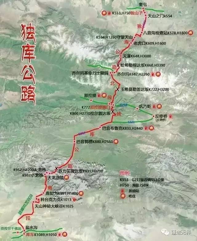
Duku Highway is a part of the G217 National Highway from Dushanzi to Kuqa ( known as Qiuci in ancient times, an important town on the Silk Road ), running through the north and south of the Tianshan Mountains, with a total length of 561 kilometers, It starts from the petrochemical town of Dushanzi in the north, goes south through the Gongnaisi Grassland and the Bayinbulak Grassland, and crosses the four Dabans of Haxilegen, Yuximole, Laldun and Tielemaiti to reach the important counties in southern Xinjiang. Kuqa. In 1974, the country decided to speed up the construction of the Tianshan Highway. The war-ready national defense highway built under the orders of the State Council and the Central Military Commission was included in the national key projects and was directly under the jurisdiction of the Central Military Commission. It took a certain engineering department of the People's Liberation Army 9 years to dig a tunnel through the "impassable" Daban, build a thoroughfare on the "impassable" Daban, and cross the insurmountable mountain... Due to avalanches It was built with the sacrifice of 168 people due to causes such as earthquakes, mudslides and other reasons.
The completion of this road has connected the direct travel between north and south in the middle section of the Tianshan Mountains , thus greatly shortening the transportation distance. Changed the past need to detour from Dushanzi to Kuqa through Daheyan or Hejing, which can shorten the mileage by 300~ 500 kilometers. It is of extremely far-reaching significance for connecting transportation between northern and southern Xinjiang, increasing the unity of all ethnic groups, developing and constructing frontiers, shortening the operating mileage of northern and southern Xinjiang, activating the economy, and consolidating national defense. The martyrs of the People's Liberation Army who died are buried in the Jorma Martyrs Cemetery. The oldest among them is 31 years old and the youngest is 16 years old. DescendantsIn order to commemorate those named and unnamed soldiers who devoted their lives to the construction of the Duku Highway Officers and soldiers, built the Jorma Monument on the Duku Highway. This is a memorial that people can never forget!
The Duku Highway all runs through the Tianshan Mountains. More than 280 kilometers of the road section are above 2,000 meters above sea level. There are three mountains above 3,000 meters above sea level. More than half of the section stretches across the mountains. , passing through the Shenchuan Canyon , passing through 5 rivers, and having the world's only snow-proof corridor, the Hashlegendaban Tunnel with an altitude of 3390 meters, was once the highest highway tunnel in China, Many places are faced with dangerous areas where "monkeys are eager to survive but are worried about climbing". Road construction is very difficult. The Duku Highway connects many minority inhabited areas . From south to north, there are the Kiziliya Mountain Landscape, the Mysterious Grand Canyon of the Tianshan Mountains, the Big and Small Dragon Ponds, the Tielimai Tida Ban, and the Bayinbulak Prairie. , Nalati, Gongnaisi, Qolma Revolutionary Martyrs Cemetery and Scenic Area, Tangbula, Dushanzi Grand Canyon, etc. , On this road, tourists can experience different scenery in five miles and different weather in ten miles. The stunning scenery was selected as "The Landscape Avenue Running Through the Backbone of the Tianshan Mountains" by "China National Geographic" .
Due to the special geographical location of Duku Highway, winter traffic control is implemented from the end of September to May of the following year . Due to the many sharp bends and steep slopes in mountainous areas, passenger cars with more than seven seats, tractor semi-trailers, freight vehicles with more than 5t and hazardous chemicals Goods transport vehicles are prohibited from passing. The highway is open to traffic from June to October, and the best time to travel is July and August in midsummer. It is not recommended to walk in winter because the snow on the road is deep in winter and avalanches may occur at any time, especially if you have to cross Daban.
The Duku Highway can be roughly divided into 4 sections based on topography and humanities. Some sections 3 and 4 are combined into one section. The first section is the northern section, the second section is the middle section, and the third and fourth sections are Southern section (from north to south):
1. The section from Dushanzi to 0 kilometers (intersection with 218): 220 kilometers. Highlights: Snow-proof Corridor, Laohukou, Tian Waterfall, Hasilgenda Ban, Choolma Martyrs Cemetery, Hasilgendaban, Tangbula. The car started to go uphill along the winding mountain road, and the most rugged section of the Duku Highway appeared. On one side of the road was a mountain with dangerous terrain. From Dushanzi to Qiolma, there are hundreds of twists and turns, including a dangerous road called "Tiger Pass". After Qiolma, the green grasslands and rivers gradually disappear, and 0 kilometers east and west are the famous Gongnaisi , Nalati Grassland.
2. 0 kilometers to Bayinbuluke section: about 60 kilometers, new scenery begins to appear from Nalati . Highlights: Nalati, Three-dimensional Grassland, Snow Ridge Spruce, Yuximole Daban (also called Turan Sala) . Say goodbye to the amazing glimpse of Ili, and come to another new scenery on the Duku Highway - Bayinbuluke. It is the second largest grassland in China after Hulunbuir . When you reach Bayinbulak, it is as vast as "a flat river" .
3. Bayinbuluk to Xiaolongchi: 120 kilometers. Highlights: Bayinbuluk Grassland, Tielimai Tida Ban, and Xiaolongchi. The large and small dragon ponds called "Nantian Lake" are also like two pieces of crystal clear emerald, inlaid on the mountainside surrounded by snow peaks.
4. From Xiaolongchi to Kuqa: 137 kilometers. Highlights: Kuqa’s mysterious Grand Canyon and the customs of southern Xinjiang. The Grand Canyon is mainly composed of sedimentary rocks. Due to the faults of the Tianshan Mountains and crustal movement, as well as years of wind erosion and rain erosion, the rock layers have undergone a series of wavy bends. Today, you can clearly see different patterns on the side walls of the canyon. Folds and fracture lines.
The 29th was the last day of our trip to Xinjiang. We took the middle and northern sections of the Duku Highway and returned to Urumqi from Bayinbuluk. We were lucky to be able to take the Duku Highway this time. Shortly after it opened at the end of May, it was closed again due to weather conditions. It was not until that the traffic control was lifted again on June 21 and it was officially opened to traffic. Xiaoxia said that we usually leave early when we return to Urumqi from Bayin. We also want to take pictures of the sunrise on the grassland, so naturally we have no objection. Before going to the Jiuqu and Eighteen Bends, we agreed to set off at 6 a.m. the next day, which was a pretty early departure time. Xiaoxia also said that she had never met anyone who set off so early, and it was usually better than this. Half an hour and an hour later. After being out for so many days, Xiaoxia also missed her family a little. She also chatted with her children on video several times, and he agreed to set off earlier.
It was a little before 6 o'clock, and everyone left the room. Xiaoxia took out the hot milk, eggs, and hot buns that had been ordered in advance at the front desk, ready to eat on the way. The sky was slightly white, not even fish-belly white, and the street was quiet, as if we were the only ones busy. The weather was a bit cold, and the two ladies were dressed almost as if they had been in winter. Xiaoxia was still very thinly dressed, after all, she was still young.
The grassland is very quiet, and the cattle, sheep and horses have not come out yet. The sky is getting brighter and brighter, and the clouds in the sky are getting redder and redder. The clouds in the sky are a bit thick, and the areas that are not dyed red are black. We are heading east, and we can always clearly observe the changes in the morning glow. Unfortunately, the distant mountains will delay the sunrise. At about 6:40, we reached the fork in the road, a dirt road going east, which can reach the anti-repair bridge of G218, and our main road turned north. This is an excellent location for taking pictures. Even if there are vehicles passing by, it will not affect us. Moreover, we can go down to the grassland to the east, which is very safe.
The clouds are turning red little by little, and there are pink tops on the snow in the south. Everything is developing beautifully as expected. We enjoy the tranquility and coldness of the grassland, and witness the beautiful changes... What a pity. Yes, the sunshine failed to drive away the dark clouds, but was surrounded by dark clouds.
We stayed here for about half an hour. Before arriving, we had eaten all the hot breakfast, and Xiaoxia also turned on the heater in the car. The moment when the most spectacular scenery we were looking forward to has passed. After staying outside the car for a long time, we felt a little chilly, so we set off on the return journey again. When passing by Laldun Daban, thousands of rays of light were projected from the gaps in the clouds, illuminating the mountains on the opposite side. Some people say that the light of Jesus is difficult to see, and the scene is very magnificent, but I feel that this is a very common natural scenery. I have seen it a lot of times, and very few of the magnificent ones. Most of them are ordinary. Maybe I don’t have enough vision. Maybe I have seen it so much that I have become accustomed to it.


The road from Laldun Daban to the 0-kilometer intersection of Nalati was basically walking in the valley. The morning light had not yet entered, so my wish to take some more pictures of the spotted forest and valley scenery failed to come true. After the 0km junction, we continued north in the valley. The valley became more crowded. Except for this road, it seemed to be the woods on both sides or the rocks carved out by road construction. . The slope of the road is not large, and there are not many bends. It is still very pleasant to walk on it. After walking for 11 or 12 kilometers, a small forest pasture appeared on the east side of the road, with a small river winding through it and green grass. There are several yurts dotted around the yurt. The sheep have just been released from the pen. As they walk further away, they don’t forget to stop and nibble a few mouthfuls of grass. The smoke from the cooking pots floats on the roofs of the yurts. The only thing missing is that the sunshine is still on the mountain. aside.
After passing this herdsman's point called Kzelashia, the road plunged into the woods again, and the slope became steeper and there were more bends. Xiaoxia and I chatted here and there, and occasionally the two of us chatted. The lady also joined, and after walking about 2 kilometers, at a bend in a mountain valley, a big bird suddenly flew from the grass on the side of the road, passing 1 or 2 meters away from the front of the car, and soon flew to In the blue sky, Xiaoxia and I both judged that it was an eagle. Xiaoxia said it might be its nest, but I said it was unlikely, because eagles' nests are all high up, not in this grass nest, let alone in the grass nest. Beside the road.
After passing two more switchbacks, the car drove forward on the winding road. After another twelve or three kilometers, there were two more long switchbacks, both of which were driven in the woods. At the second switchback, there are no trees blocking the hillside beside the road. You can see the snowy peaks in the distance and the mountain ridges nearby.
We parked the car to walk around, take photos, and look at the scenery. After about ten minutes, we continued moving forward. We soon got rid of the visual interference caused by the spruce trees, and the valley became wider. The road follows the ridgeline of the top of the mountain and crosses the hillside. The tall mountains and deep valleys are all green with green grass, and the trickles at the bottom of the valleys are very eye-catching. Just admiring the scenery, the car gradually climbed higher, and finally passed through the snow-covered tunnel at the entrance of Yuximole Daban. From a high place, the snow-capped mountains in the blue sky felt within reach.
The car quickly went down the mountain and came to a large mountain pasture. It was very smooth and smooth. Ms. C proposed to take pictures. The scenery was beautiful, but there didn’t seem to be any shots I liked, so I just took a stroll on the grass by the roadside. After a while, Xiao Xia told me that there was a groundhog in the grass. When I was in Xiata, I said I didn’t take a picture of the groundhog, but I didn’t expect that he would always remember it.
The prairie dog is within the fence of the pasture, very close to the road. I changed the telephoto lens, and the prairie dog is still gnawing grass. Maybe because I knew I wouldn't hurt it, I didn't run away even if the camera was pointed at it.
When the car arrived at the intersection of Qiaoerma, Xiaoxia told us that there was a road construction monument. Do we need to visit it? A lady asked not to visit it, and Xiaoxia also said that she would usually visit it. Because I didn’t do any homework in advance, I didn’t know that there was a cemetery for road construction martyrs here. I didn’t raise any objection, so the car just crossed the Kashgar River and continued moving forward. Now I feel very sorry. This dangerous road was paved by them with their lives, and we should pay tribute to it.


 The scenery around Qiaoerma is very beautiful. In addition to the Martyrs Cemetery, there are also scenic spots. Of course, we didn’t go there. Not far after passing the Jorma service area, we re-entered the mountain road. The grassland on both sides of the road gradually became sparse. In the end, there was almost only a thin layer sticking to the ground, and the color was not that emerald green. , but somewhat yellow.
The hillsides on both sides of the road gradually became covered with snow, and the surrounding peaks were also clustered around us. At about 10 o'clock, the car stopped in a wide open space beside the road. The snow line was already lower than where we were. The hillside is very steep, about 40 degrees, and the road winds around the mountain for a long time. Unfortunately, without a drone, it is impossible to clearly see the momentum of the winding mountain road.
Surrounded by mountains, the top of the mountain is covered with white snow, which may have fallen not long ago. There is a patch of rocks below the snow line, and below it is a meadow. Standing close, I feel that there are not as many grasses as there are pebbles. From a distance, it is still green, like a green velvet blanket fluttering on the hillside. There is a rainwater ditch on the slope, which is formed naturally due to the drainage of melted snow and rainfall. The grass on both sides of the ditch is slightly lusher than the surroundings. Suddenly, I saw a black shadow running from top to bottom in the grass beside the ditch. When I took a closer look, I saw something. None, just some piles of green grass, and a few clear tuts, revealing the location of the black figure, and a yellow thing sitting in the middle of the grass - another prairie dog. Come on, come back one after another.
The distance was too far, and the prairie dog’s silhouette in the telephoto lens was still a bit small. I simply took a few photos and prepared to get back in the car and continue on my way. Xiaoxia said that I would have to stop here for 20 minutes. I said, Then I might as well go down the slope and shoot the prairie dogs. Going down the steep hillside from the upper section of the small ditch, we found that this area was a mixture of soil and gravel, and there were even several small ridges half a meter high. After walking a few steps, we found another plump soil dog. Rat, grinning at me from ten meters away, called it. I walked down and it continued to bark. It found that I ignored it and continued to walk down. It also turned around and ran down for a while. On a soil He continued to shout at me in front of the ridge, and when I continued walking, the guy suddenly disappeared, leaving a big hole in the ridge. Haha, that’s it. I walked all the way to the patch of grass where I first saw the prairie dog, and there was also one in the middle of the patch of grass. Holes, no wonder they are so bold.
Going further up, there is occasional dark ice on the road due to melting snow and water flowing through it. Vehicles need to proceed with caution. There is also a snow-proof corridor hundreds of meters long. I have seen this many times on the way to Tibet. There doesn't seem to be one this long. In front of us are rolling snow-capped mountains, with snow on all sides of the slopes. A trapezoidal black hole looks very abrupt - we have reached the highest point of the day, the tunnel of Hashlegendaban.
After passing the tunnel, we entered a long downhill road. Not far from the hillside, there was a not very sharp switchback. There were some vehicles parked in the snow outside the road, and there were many tourists there. Playing in the snow, but the snow is really a bit dirty and the surface is a bit black.
The mountains on the north slope no longer have the emerald green of the south slope. The exposed mountains are all grey-brown gravel. Not far from the top of the mountain, there is a lake with picturesque reflections. It feels very good, but the water It was so cold that I, who can wash my hands with snow, felt the biting pain within three to five seconds of putting my hands down.
The steepness of the road, the towering mountains and the gravel are comparable to those of 318, but still slightly inferior. The three of us have all walked on 318. I have also been to the Rongbuk Monastery on Mount Everest, and the road is even more steep. Even 318, so we were a little used to the precipitousness , so dangerous places such as the Tian waterfall and the tiger's mouth did not arouse our exclamation. I chatted with Xiaoxia relaxedly. The only thing Unfortunately, in this section of the valley and the winding road, there is no drone, so it is a pity that I cannot take pictures of the beauty of the valley.


There were many cars parked in the parking lot at the "Guardian Tianshan Road" monument. Some tourists took photos in front of the tall monument. I wanted to take a photo without anyone in the picture. After waiting for a long time, I still didn't get it. .
The road further down is a little smoother, but the squeeze on both sides of the canyon remains the same. There were more and more cars going up. Xiaoxia said that he had seen photos taken from almost all the cities in Xinjiang, and of course some from other provinces and cities. By the time they reached Bayingoukou, the cars entering the mountain were almost in a line. It was estimated that There are more cars than there are on the streets of Dushanzi City. There may be a traffic jam on the Duku Highway soon.
I murmured again in the car that we have seen rainbows, snowy mountains, and prairie dogs, but not eagles... Ms. C said in the back seat that there is no chance of seeing eagles. I said not necessarily. , I have just left the mountains and entered the grassland, and now I am focusing on hunting eagles. As he spoke, he put a telephoto lens on the camera, opened the shutter, and held the camera in his hand. Not two minutes after I finished speaking, an eagle flew in our direction from the grass on the left. I quickly put down the car window, picked up the camera and faced a snapping sound.
G217 Highway 554 is the starting point of Duku Highway. After passing here, we have arrived at Dushanzi, which is about 1 noon.
We had another meal of soup and rice in Dushanzi, and then drove to Urumqi. Classmate Zhang specially invited a Kazakh friend to come and sit with me. That friend is also a caterer and has a restaurant in Nanshan Ranch. His Mandarin was pretty good, and he said that his restaurant was not far from here, but it was a bit inconvenient to eat in his restaurant. I asked why it was inconvenient, and he said that he had to go to other tables to toast there, which was not good.
The two guys drank me to the point of being knocked unconscious (according to my Kazakh friends, I drank freely, not drunk at all), threw me on the hotel bed and walked away. 


On the morning of the 30th, I went to visit the Xinjiang Museum and wandered there for about three hours. This time I finally made the trip. It was only the third time. I had reserved a window seat the day before, and I didn’t pay attention when I changed my boarding pass. I never thought that the airport guy would move me forward to a seat next to the aisle. It wasn’t until I boarded the plane that I realized that Yun Hai and I were walking along the way. Say goodbye.
A friend asked, are you still going to Xinjiang? I said I would go again, and planned to go twice, once to southern Xinjiang and once to northern Xinjiang: the scenery and culture are different, and they all need to be appreciated in detail.