
During my summer trip to the northwest in 2018, in addition to the must-visit cities such as Qinghai Lake and Lanzhou Xining, I also wanted to add a mountain peak to my itinerary. Among the famous mountains in the northwest, Taibai Mountain, the main peak of the Qinling Mountains in Baoji, Shaanxi Province, stands out. Compared with the famous Three Mountains and Five Mountains at home and abroad, it is slightly niche but has a unique charm. It is a mountain that is more suitable for outdoor hiking. In the outdoor circle, there is a saying of North Taibai and South Kungfu. As the main peak of Qinling Mountains, Taibai Mountain separates the north and south of the motherland. It is the watershed of the two major river systems of the Yangtze River and Yellow River. It has the remains of Quaternary glaciers. Vast stone seas can be seen everywhere, and around the main peak, Baxiantai, there are six independent glacial lakes including Daye Lake. Taibai Mountain can be regarded as one of the must-visit destinations in this life, so two days before leaving, I resolutely added it to the itinerary and quickly prepared a strategy. Of course, I was the only one who started this trip due to other reasons, and the preparations were in a hurry. I did not take the Aotai Line, nor did I plan to cross Taibai Mountain from north to south. I only took the two-day route recommended by the scenic spot, which involves climbing to the top and returning the same way. And be prepared to hike the whole thing without taking the cable car.
1
Departing from Hangzhou on August 7, we arrived in Baoji at noon the next day. Baoji, known as Chencang in ancient times, is located in the Guanzhong Plain. The Wei River, the largest tributary of the Yellow River, flows through the urban area. Because I planned to start climbing as early as possible the next day, I planned to rush to the foot of the mountain and stay overnight. Taibai Mountain Visitor Center is located in Tangyu Town, Mei County, Baoji. You can take a shuttle bus directly from Baoji and Xi'an, or you can take a shuttle bus to Mei County. There are many buses to the visitor center in Mei County every day. I rushed to Baoji Bus Station and learned that there is only one shuttle bus to Tangyu every day, and the time is 4:30 pm (it does not match the official Taibai Tourism website). After buying the ticket, with 3 hours left, I decided to go for a walk along the Weihe River.
Weihe, you are thinner than you thought

Even though it is the largest tributary of the Yellow River, the water volume of the Wei River is not large at this time, and it is even narrow enough to wade through. The Wei River accepts its main tributary, the Jing River, and merges into the Yellow River in Tongguan, Weinan. Rivers can bring water resources and impact plains. Ancient humans discovered that the riverside is suitable for reproduction and survival, so many cities are built by the water and have a mother river. The Wei River Plain impacted by the Wei River, also known as the "Eight Hundred Miles of Qinchuan", has been a fertile land since ancient times. Standing by the Wei River, watching the river flowing quietly, I thought of the "mother rivers" in the south that often have sufficient water and are mostly navigable, while in Hualien where water resources are scarce. North-west, I’m afraid we’re going to run aground.
Return to the bus station and take the shuttle bus to Tangyu. After driving on the highway for about an hour and a half, we arrive at the Taibai Mountain Visitor Center, which is quite impressive. It was already evening when we arrived, and it was a bit hot at noon, but now it was very cool. Looking up, you can see the continuous Qinling Mountains, which are quite impressive. Tomorrow, we will start from here to reach the main peak of the Qinling Mountains.
Taibai Mountain Visitor Center

After sitting in the visitor center for a while, someone came over to sell accommodation in a farmhouse at the foot of the mountain. They bargained for 70 a night, so we took their electric tricycle there. This season they have to go to the visitor center to attract guests to stay, one by one. The farmhouse is a two-story building with the advantage of being spacious and quiet. After settling in, I went to have dinner nearby and bought food and water for climbing the mountain tomorrow. It is said that food on the mountain is very expensive. I probably brought two or three meals with me, but I couldn’t carry more than that. Because I expected to take the bus directly at the tourist center when I returned, I carried all my travel belongings - a backpack - which weighed nearly 10 kilograms. Although it is considered a light hike, this time it is not light.
2
The first morning we woke up in the northwest was sunny and cool. After having breakfast at the host's house - steamed buns and eggs, the host sent us to the visitor center. All tourists must purchase a ticket plus a scenic transportation ticket, which means they must take a scenic transportation bus from the scenic area, along the winding mountain road to the cableway entrance or the starting point of hiking, and will stop at several scenic spots along the way. The scenic spot ticket is 100, the transportation ticket is 60, and the combined tickets I bought at the official Tmall store total 146. There are a lot of tourists at this time, and transportation buses in the scenic area are issued as soon as they are full. I actually waited until 9 o'clock to set off after collecting the tickets.
For the two-day hiking route, I plan to take the scenic shuttle bus to the starting point of the mountain climbing—Xiaban Temple (2,700 meters above sea level), follow the hiking trail to Shangban Temple, Xiao Wengong Temple, and Da Wengong Temple, and stay in the Dayehai iron house that night. The next day, we watched the sunrise at Baxiantai, visited Eryehai and Sanyehai, and finally returned the same way. This route is quite difficult on the first day, but much easier on the second day. The task on the first day is to get to Dayehai.
Mountaineering route map

The scenic spot shuttle bus departs from the visitor center at an altitude of more than 600 meters and stops three times on the way. The first stopping point is Lianhuafeng Waterfall.
Lotus Peak Waterfall

After getting off the bus, walk along the sign and pay attention when you see a place where tourists gather. When you look up, you see a waterfall with a large drop hanging down from the mountain. Approaching the waterfall, I felt a coolness that was different from other places. This attraction is still worth seeing. Going forward, we will also stop at places such as Xanadu, because my destination that day was Dayehai. Considering that the schedule was quite busy, I did not get off the car at the parking point and continued up the road with the driver. But at Honghuaping (which is the starting point of the Tianxia Cableway), you have to get off the bus and transfer to another car going up, and continue driving to Xiaban Temple. The altitude here is 2,700 meters, which is far higher than the highest point I visited before, which was more than 1,900 meters. This is the starting point for climbing. I made a slight adjustment and got ready to go. By this time, I was already feeling quite chilly. The display at the Shimoban Temple Visitor Center indicated that the temperature on the mountain was only 5 to 8 degrees. I only brought a long-sleeved shirt and a thin jacket. I was a little worried, but I thought it would be fine when I climbed the mountain. If you have a fever, you won’t freeze to death in summer. In fact, this paved the way for me to catch a cold that night in the mountains.
3
There are two roads branching off from the entrance to the Xiaban Temple mountain climbing. The one on the left is a certain scenic spot, and the one on the right has a sign - "Starting point of the mountain climbing". Compared to the hustle and bustle on the left, there are almost no people on this road. I estimated the climb. The height difference between here and the highest point of 3,767 meters is about 1,000 meters. I thought that this climb is not too big. Whether it is Wuzhi Mountain, Wugong Mountain, Mount Tai, or the wild mountains west of Beijing or the mountains around Hangzhou, the height from the foot of the mountain to the top of the mountain is If the difference exceeds this number, it shouldn't be a problem this time. In fact, during this hike to the top of the Qinling Mountains, firstly, I had to carry a 10kg backpack (plus a SLR), and secondly, the altitude was basically above 3,000 meters. In addition to climbing, there was also a long distance of walking along the transverse line. It was really not easy. easy.
This was my first time hiking with a SLR. The camera body and lens weighed about two kilograms. It was inconvenient to put it in a backpack and hung precariously around my neck. This time I used a belt, which does not affect hiking when carrying the SLR, which is convenient and labor-saving.
camera belt

At first, it was a wooden plank road built in the scenic area. It made a creaking sound while climbing to the same height. It was the easiest to walk on this kind of road. The wooden plank road can also provide a certain buffer for the knees, but you have to take a break when walking at such an altitude. The vegetation on both sides is mainly coniferous forest. The trees are not tall, but they seem to be very old. The plants grow slowly in the alpine environment. The clouds and mists in Taibai Mountain change frequently, and they always feel wet. The moss and wild flowers growing under the trees also confirm this climate. From time to time, I saw squirrels jumping among the branches. When I picked up my camera to take pictures, I couldn't find them. It seems that the ecology of Taibai Mountain Nature Reserve is still well protected. Walking in the coniferous forest, I feel a primitive and vigorous vitality, which is different from the shrubs and broad-leaved forests I passed through before climbing the mountain.
Taibai Mountain Coniferous Forest


In fact, this mountain range still retains the breeding grounds of many rare creatures. The crested ibis is hiding in a corner of the dense forest. There is also a unique brown giant panda living in the Qinling Mountains. It is still a natural habitat for wild animals. Gene data bank.
Passing through Banji New Village, Baisendai, and Shangbanji in turn, it started to rain. After a while, the rain became heavier, so I quickly held up my umbrella. The altitude of Taibai Mountain changes greatly and there is a microclimate. We encountered quite a bit of rain and even thunder on the mountain in the past two days. I am not afraid of rain. The mountains look more mysterious and charming against the backdrop of rain and fog. Especially when walking on the ridge, you can appreciate the various characteristics of this weather. So I’m quite looking forward to rain and fog, and the unpredictable clouds and fog in Wugong Mountain are still fresh in my memory.
At an intersection, one road leads to the top of the mountain - Tianyuan Place, which means a considerable climb. The other road goes around the top of the mountain from the side, and the two roads meet at the entrance of the nature reserve. I chose the latter, which saved me a lot of energy, but I would miss a monumental stone tablet with the "Boundary Point between North and South China" engraved on it. From the perspective of enjoying the scenery, this scenery can be ignored, and the truly shocking scene is yet to come.
Entrance to Taibai Mountain Reserve

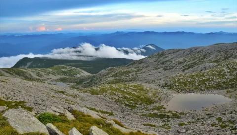
Walking to the entrance of the reserve, the view suddenly broadened, and then we basically walked along the ridge. Looking from both sides, the mountain ridge rises like a sharp blade from the foot of the mist-shrouded mountain. The two sides of the ridge are steep and have a huge drop. Half of them are covered by coniferous forests and the other half are stone seas. The Qinling Mountains are the dividing line between north and south in China and the watershed between the Yangtze and Yellow Rivers. Going down from both sides of the ridge, there are two different climates. The warm and humid air flow from the south is blocked by the huge Qinling Mountains, and the cold air from the north cannot penetrate this natural barrier.
A mountain divides north and south

Walking on the ridgeline

Not far from the Taibai Mountain Reserve is the Xiaowengong Temple. There is a foreign affairs checkpoint here. Passing tourists need to register here, and foreign friends are not allowed to enter from here on. It is said that there is a military base inside. I did the entire two-day trip to Taibai Mountain. Didn't see any foreign faces. Xiaowengong Temple is 3,470 meters above sea level. There is accommodation here, but it is still far away from Dayehai, my destination tonight. From the Little Wen Gong Temple to the Big Wen Gong Temple, there is not much climbing, but the distance is long, and you basically walk on a slope made of rocks. Sometimes the clouds and fog cover the place, and people in front and behind cannot be seen. Sometimes the fog dissipates, and you can see that this transverse line is winding and seems to have no end.
Shihai


The rain is heavy and sometimes light, but the sea of stones in front of you is endless. This is a geological landscape left by the Quaternary glaciers. When the clouds and fog cover the environment on both sides, it actually feels like a construction site. With a few excavators, it looks more like it. When the mountains appear in front of you, you think that it is more than 3,500 meters above sea level. There are only a few tourists and you can't see it. There is a little smell of fireworks, but the city is still far away.
Landscape of alpine meadows and stone sea

I don’t know how long I walked, but I saw a few blue iron houses on the pass in front of me. This is the Dawen Gong Temple. There is a long uphill slope going forward from the Dawengong Temple, which seems to be called the Despair Slope. The name of Despair Slope is found in many mountains. It is roughly the longest and steepest uphill slope on this route, and Dawengong Temple is the last place to stay in front of Dayehai. I did not repair at Dawengong and continued to climb. It was almost four o'clock in the afternoon. Fortunately, the sunset in the northwest was very late at this time, almost to eight o'clock, which was still plenty of time. From Dawengong to Dayehai, the height difference is not big, but you need to go up and down along the ridge. Sometimes the clouds are right in front of you and at your feet.
Clouds are always with you


Sometimes the fog is like a big net, attacking the ridge at a speed visible to the naked eye. I quickly pick up the camera and press the shutter when the fog happens to spread to the ridge.
Mist rolls over the ridge

Suddenly, after climbing over a small mountain peak, several blue iron houses came into view in the distance, which were probably Dayehai. Walking in again, you see a lake located in the mountains, and finally reach Dayehai! !
The iron house is located beside Daye Sea

4
After settling down for a while in the iron-clad house of Uncle Hai, I looked at the time. It was past five o'clock in the afternoon and the sun was still high. I decided to put down my backpack and bring only my SLR to continue admiring this mountain heritage.
Uncle Haizhenrong


Dayehai continues to move forward, and there is an uphill slope. Climbing up this slope, the field of vision suddenly broadens. The mountains in the distance are undulating, and the clouds seem to be carved on the peaks. As the sun sets, the clouds keep changing their shape. Light and shade and color, and intensify.
Thousands of clouds


The mythical beast of Taibai Mountain patrols the mountains at sunset

In the other direction of the summit platform, I accidentally discovered that there are two lakes not far apart. The two echo each other. I wonder if they know that across the mountains, there is a larger and deeper lake, which is their elder brother. .
alpine glacier lake

The setting sun finally approached the horizon, the temperature dropped rapidly, and there was a lot of wind blowing from the top of the mountain. I hurried down, otherwise it would be difficult to go down the mountain after dark. The setting sun casts long shadows on the sea of rocks on the top of the mountain. It was August at this time, but the sunshine on the top of the mountain was like winter sun, without much temperature. It was several seasons apart from this morning.
The setting sun casts long shadows on the top of the mountain

Returning to the Tin House, the accommodation here is worse than expected, worse than anything I have experienced before and what I found online. In this tin room, three bunk beds are put together for five people, with bunks on the upper and lower floors, regardless of gender. At a rough count, it is estimated that there are more than 120 people living there. Everyone is crowded here. The air is dirty, humid and hot, and some people are snoring loudly. It is even more uncomfortable than a hard seat on a train. It is said that it costs more than 50 per person in normal times, and 70 to 100 in peak season. When I got here, I found that it was 150 per person. Although the electricity supply here is troublesome and material transportation is difficult, there is only one hotel here. All tourists who come here can only stay here for one night. The boss can't help how much he charges per person. Next time I have a chance to come here, I might as well re-camp, the environment is much better than inside.
A tin house that houses more than 120 people

The place to eat is in the iron room next door, and the supply of alpine supplies is difficult. Even so, I was still surprised when I saw the price list. But being able to eat well outdoors is great, but being able to eat delicious food is almost unimaginable.
It would be great to be able to eat and serve food in the mountains.

In comparison, the accommodation environment in the tin houses in Wugong Mountain is much more comfortable. It is closer to the inhabited area at the foot of the mountain, you can take a bath, and there is a long electricity supply. The tin houses are not big but clean, and you can even open the windows. You can see the alpine meadows and mountains - a good viewing room. This shows that the environment of Taibai Mountain is more dangerous and far away from the crowds of the city. It was originally an uninhabited area. Due to the development of the scenic spot, people started to set foot here.
There was no cell phone signal at night, and I couldn't take a shower. When it got dark, it was time to go to bed, and I started to have a headache and a runny nose. At night I was wondering whether it was a high fever or a cold. If it was high altitude sickness, I was lucky that the symptoms could be relieved by going down the mountain. If it was a cold, I should be lucky. This just means that I won’t have any high altitude sickness symptoms at this altitude. In fact, this was probably caused by catching a cold due to the cold wind on the top of the mountain that evening. The symptoms lasted for more than a week. After coming down from the mountain, I had to go to the clinic to get some cold medicine in Lanzhou, which also affected the rest of the journey. of interest. This is the first time I caught a cold while traveling. Next time, I remind myself not to catch a cold. Once I get sick, I really don’t want to do anything.
5
I was woken up at 4:30 in the morning because many people wanted to watch the sunrise, and I also planned to watch the sunrise. When I woke up, I still had a splitting headache and a runny nose. I was struggling to figure out whether to watch the sunrise or not. Many people were up and couldn't sleep anymore. I simply got dressed and found that I could still hold on. I suddenly became more interested in watching the sunrise. The sunrise in the northwest is after 6 o'clock at this time, which is still a long time. I packed my camera, food, and flashlight and went out.
The sky was getting brighter, and the moon was still in the sky. The moonlight illuminated the calm Daye Sea, showing two different colors. At this time, the sea is like a mirror, reflecting the stars and the reflection of the mountains. It is the most beautiful dressing mirror in Taibai Mountain.
Under the morning light, the sea is like a mirror

To climb up to Baxiantai, you need to climb up a slope with a sea of rocks. The same journey today is much more difficult than last night. I had to take a break after walking a few steps. I just wanted to climb to the top of the mountain quickly. I just feel that the sky is getting brighter and brighter, and there is already a dazzling blush on the horizon, which is very spectacular. In fact, the morning glow is no less beautiful than the sunrise at this time. While looking for a path among the rocks, I watched the time and made sure not to miss the sunrise. Finally, I reached the top of the slope, only a flat road away from Baxiandai.
Baxiantai, with an altitude of 3767 meters, is the highest point of Taibai Mountain, the main peak of Qinling Mountains, and the highest point east of the Qinghai-Tibet Plateau. With an average altitude of more than 4,000 meters, a small hilltop on the Qinghai-Tibet Plateau is enough to overlook the famous mountains in the east, but Taibai Mountain rises from the foot of the mountain at an altitude of more than 600 meters. The huge height difference brings a shocking visual experience. The vegetation shows a significant vertical distribution, from the broad-leaved forest at the foot of the mountain to the coniferous forest on the mountainside to the alpine meadow at the top of the mountain. It is like a natural botanical garden. There are four seasons in a mountain, and the weather is different ten miles away. The climate in the mountain is unpredictable, and clouds and fog come. Go again; the isolation of altitude and the barrier of rolling mountains allow rare wild animals to survive here. Affected by human activities, their habitat has become smaller and smaller, and they can only settle in a corner deep in the Qinling Mountains.
Standing at Baxiantai and looking eastward, a sunrise is about to come. At this time, many people had gathered here. The terrain of Baxiantai was steep, with cliffs on three sides. It was only surrounded by a few wooden pillars. If the crowd was slightly crowded, there might be a danger of falling off the cliff. I did not pass by the wooden pillars, but chose a place with few people and stone walls. It was much safer. I looked at the time and found that I could see the sunrise in a few minutes.
Baxiantai, the highest point east of the Qinghai-Tibet Plateau

Watching the sunrise from the top of the Qinling Mountains


The weather in the morning was very good, the sun was particularly bright. After watching the sunrise, except for being a little cold, I felt good and my body didn't feel that bad. I returned to the tin house and slowly packed my luggage. I was almost the last one out of the tin house. Today’s trip was much easier than yesterday. It was almost all downhill, and we set off much earlier than yesterday. It seemed that we could reach the foot of the mountain very early in the afternoon.
Compared to the clouds and fog yesterday, the visibility today was much higher. White clouds in the distance were wrapped around the top of the mountain, as if they were competing with each other for decoration. Walking on the ridge and looking into the distance, the mountains are stacked on top of each other, showing different shadows due to the distance. You can't see the end or the town. The momentum of the Qinling Mountains suddenly appears. If you hike down the mountain directly from where you can see it, you don’t know how long it will take to get out of the Qinling Mountains.
A sweeping view of the rolling hills


The physical discomfort has a great impact on me. I just want to go down the mountain quickly, stop and go, and pace slowly. In the reverse order from yesterday, I passed by the Da Wen Gong, Xiao Wen Gong and the entrance of the reserve one by one. It doesn't seem far, but actually it takes a long time to walk. I finally finished walking on the stone road and entered the wooden plank road. At this time, I entered the coniferous forest. Suddenly, several colorful blood pheasants appeared in sight. They seemed not good at flying and not very afraid of people. I was the only one who could rely on them. He escaped from under the tree very close to him. This was one of the spiritual creatures encountered in Taibai Mountain.
Several blood pheasants came into my sight

Walking to the mountainside, the sky gradually changed, and soon a few drops of rain fell, and the microclimate of Taibai Mountain appeared again. I quickly took out my umbrella, and sure enough, after a while, the rain became heavier and I had to descend along the wooden plank road in the rain. Most of the people I met on the road were tourists going up the mountain. They were wearing raincoats and they went up the mountain even faster than I came down. From time to time, people asked me how long it would take to arrive. I had to tell them kindly that it would be soon and I could rest not far ahead. But I was complaining in my heart that the descent today was so long.
It was around two o'clock in the afternoon when I walked to the bus stop at Xiabanji Temple and got on a return bus. I could finally have a good rest. The transportation vehicles in the scenic area take tourists from the foot of the mountain to an altitude of more than 2,700 meters. The climb is still difficult. Just imagine, without transportation, the journey to Mount Taibai would be many times more difficult. Li Bai, the poet immortal, wrote a poem: "There is a bird path in Taibai in the west, which can cross the top of Emei", which shows its momentum. Compared with my previous experiences, the climb and distance this time were not very large, but the level of fatigue was not small. Taibai in the north and Wugong in the south. Wugong Mountain is famous for its large area of alpine meadows, while Taibai Mountain is famous for its unique landscape brought by its high altitude. Although it is indispensable to work hard, the trip to Taibai Mountain is not worthwhile!