Self-driving in Mexico | Spanning 4,500 kilometers, from the plateau to the capes

What does Mexico come to mind? Is it a gunfight, drug dealing, kidnapping, or language barrier or long distance? No, no, no, these stereotypes are too deep in our minds, and they seem to be an obstacle for Chinese people to go to Mexico. This trip benefited from a cheap air ticket and sufficient time. The 15-day self-driving made it possible to reach destinations that are difficult for most tourists to reach. These places also provided the biggest surprises in the trip.
Along the rugged mountain road, run from the plateau to the sea, and then through the dense Mayan jungle to the central interior, or to the cold plateau towns and colonial-style colorful towns. Only when you get close to it and walk in it will you know; it turns out that Mexico is the noisy crowd of vendors under the tower in Latin America, the Mayan ruins on the blue seaside of the Caribbean, and the monkeys flying on the branches of the Palenque jungle; it is the natural gentleness and enthusiasm The land is colorful; they are Aztec, Teotihuacan, and Chichen Itza; they are names that once only appeared on maps. It spans the land of China and the United States and is a wonderful combination of all unrelated things: cities and small towns, deserts and seas, classical and modern. During the 15-day trip, I drew a circle on the Mexican land with my wheel, carefully recording a Mexico beyond my imagination.
Day1. Mexico City
The starting point of the journey is naturally the largest metropolitan area in the Americas. In just 15 days, you have to drive around Mexico, so every minute and every second on the road is naturally compressed to the extreme. Even though Mexico City is the most central stop in the entire country, you can only get 24 hours. Starting from the Constitution Square in the city center, within a radius of one kilometer, there are attractions such as the Cathedral, the National Palace and the Aztec Temple. Go all the way along the Reforma Avenue and climb the Torre Latinoamericana, which was once the tallest building in Latin America, to overlook the city. Stretching to the distant horizon, the lights of thousands of homes make the sky bright.


The distance from Mexico City to Campeche on the Yucatan Peninsula is 1,200 kilometers. In order to visit more places in just 15 days, I had no choice but to choose a self-driving trip without any stopping points on the second day of the trip. After all, you don’t want to waste every moment while traveling. Faced with the high cost of returning the car to another place, this is a desperate solution. Starting from Mexico City at 6:30 in the morning and arriving at the hotel in Campeche at 23:30 in the evening, it took a full 16 hours (there was an hour of time difference in the middle). Looking back now, I am afraid that such a crazy drive will ruin my life. I won't do it again.
Day3. Campeche
Campeche was named a World Cultural Heritage by UNESCO at the end of the last century. This colonial city next to the Gulf of Mexico is like a paradise far away from the hustle and bustle - narrow stone brick roads, brightly painted buildings, strict fortresses, 16- The 19th-century mansions constitute the most common scenery in the small town. The town’s exquisite mansions have been lovingly cared for, renovated and restored by generations of Campeche residents. Campeche is very small and can be visited in half a day; the ancient city attractions are arranged around the central square, and are basically within a 100-meter walk. It is a small seaside town suitable for vacation.


Day4. Merida
Merida is the capital of the state of Yucatan and the largest city and transportation center in the entire Yucatan Peninsula. After being conquered by the Spanish in 1542, the city’s name was changed from the Mayan T’ho to Mérida. Merida was rated as the first destination in Lonely Planet Mexico's Top 21. The city never lacks color, art and music, and the old town is also full of colonial style. In a sense, Merida is an enlarged version of Campeche. As the largest city in the Yucatan Peninsula, it naturally attracts more foreign tourists. Whenever night falls, the city is already a sea of music, filled with activities and dances. Watching the carriages passing by on the stone streets, it feels like being led by a time machine to a small town in Andalusia.


Day5. Uxmal & Puk Road
Uxmal, an hour's drive from Merida, is an important city-state in the entire Mayan civilization. Compared with the huge crowds of Qiqinycha, there are only a few tourists here. The city was founded in 600 AD. At its peak, Uxmal was home to approximately 2,500 people. It was abandoned in 1000 AD due to lack of water. In the Mayan language, Uxmal means "three times built," referring to the multi-story structure of its building.
Uxmal is located in Mexico Puuc Region ), Puuk means "hill" in Mayan. and the Mayan city-states east of Yucatan (Chichen I Unlike the ancient Yucatan Peninsula (Tulum), the biggest natural feature here is the lack of water. Not only does it lack surface water, it also lacks the natural wells that are common in the eastern part of the Yucatan Peninsula. More than 1,000 years ago, the Mayans created a kind of Chultun (translated as a reservoir) to provide a continuous water source for the settlement by storing rainwater. It was precisely because of this fatal flaw of lack of water that the Mayans did not begin to live in the Puuc area on a large scale until the 8th century AD (the end of the Classical Maya period); and more than 200 years later, with the fall of the Classical Mayan civilization, most of the cities were also abandoned. In addition to the largest ruins in the Puuc area Uxmal In addition, there are five Mayan ruins around it, including Kabah, Sayil, Xlapak, Labna and Grutas de Loltun. The road connecting these Mayan ruins is called the famous Ruta Puuc.


Day6. Chichen Itza
There are no words to describe this place except the crowds. Chichen Itza is to Mexico what the Great Wall is to China. More than 2.6 million tourists flock here every year. If you want to find a quiet place to see the ruins here, it is impossible. Chichen Itza symbolizes the highest level of the Mayan calendar. The main pyramid and observatory ruins all show the Maya's proud talent. It is a pity that these calendars only stay on the surface of writing and counting, and most of them are used in religion. Sacrifice has not developed into a complete scientific system; no matter how much it is said, it has not been applied in actual combat. It relies entirely on God's orders. As a result, European civilization came from behind and was eventually conquered, which is embarrassing.


Day7. Tulum
Heading east from Chichen Itza, you will soon reach the seaside of the Yucatan Peninsula, where the famous resort Cancun is located. Perhaps tired of the noisy European and American tourists on the beach, Cancun was not planned on this trip, but instead went to Tulum, more than 100 kilometers south (although there are also many tourists here). Built in the Mayan postclassic period, Tulum was the last city built by the Mayans. It reached its peak from the 13th to the 15th century. It was not until the Spanish occupied Mexico 70 years ago that Tulum finally perished. The reasons for its demise have been attributed. Diseases brought by the Spaniards. Tulum was once called Zama, which means City of Dawn, probably because it is located at the easternmost point of the entire Mayan world and is the first city to bathe in the sunrise. The walls and cliffs surrounding Tulum made it more vulnerable to enemy invasion. This was the port of foreign trade for the Maya. Goods from the Caribbean and Belize were transferred through Tulum to places such as Coba and Chichen Itza inland. At its peak, the Tulum dynasty's trading reach extended into Guatemala and Honduras.


The nearly 9-hour drive from Tulum to Palenque was the second long-distance self-driving segment in this trip. Fortunately, the time difference was -1 in the middle, so I felt comforted that I only had to drive for 8 hours today.
Day9. Palenque
It is hard to imagine that such a huge Mayan city-state is hidden in the dense forests of the mountains in central Mexico. Palenque, formerly known as Lakamha, means Big Water. Its ruins date back to 226 BC to 799 AD. After its decline, it was quickly submerged by the jungle and was not discovered until the mid-18th century by Spanish colonists. In 1952, Mexican archaeologist Alberto Ruz Lhuillier removed a stone slab from the back room of the inscribed temple building while doing in-depth excavations in Palenque. He unexpectedly discovered A passage was discovered, and through a long staircase, Alberto Ruz Lhuillier discovered a tomb containing a sarcophagus. The coffin lid is carved from a whole piece of limestone, weighing 5 tons, and is carved with a relief of the "Maya Astronaut" that still causes a great sensation today. When the coffin was opened, the surface of the coffin was covered with red cinnabar, and inside lay a tomb owner whose body was adorned with gems and whose face wore an inlaid emerald mask. He was the legendary king of Palenque: Pakal. The discovery of this pyramid tomb is a milestone. Before this, people generally believed that Mayan pyramids were only used for religious and sacrificial purposes. The discovery of Palenque broke this rule-Mayan pyramids can also exist as tombs. The area of the entire Palenque city-state is really too large, but at present Only 5% of the area has been excavated, and there are still a large number of architectural remains and palaces. It is hidden in the dense jungle and is waiting for people to explore.


Day10. San Cristobal
Driving out of the Palenque jungle and winding along the road in the mountains of central Mexico, you will soon arrive at this small plateau town with a somewhat unpronounceable name. The full name of San Cristóbal is San Cristóbal de las Casas. The small town is located on a plateau at an altitude of 2,200 meters. You can feel the biting chill as soon as you get off the car. Before coming here, I saw a travel note mentioning that this place is like a Mexican version. I walked around the city in Dali, and it turned out to be very similar. In addition to the high altitude, bright sunshine and blue sky, there are Mexican artistic youths all over the city, all holding guitars and wearing dreadlocks. The same songs are played in roadside cafes and hotel restaurants, pushing Posi away The Mia-style restaurant door has a young and lively atmosphere. I never expected to discover another side of the country in the mountains of Mexico, far away from the hustle and bustle.


Day11. Oaxaca
Heading west from San Cristóbal and diving into the mountains of the central plateau of Mexico, Oaxaca appears in front of you inadvertently. It has the largest ethnic minority in Mexico. In an era when transportation was underdeveloped, mountains became barriers to protect various ethnic groups. Even though their cultures had the same roots, they developed different characteristics due to limited exchanges. The old town of Oaxaca is not big and can be walked in half a day. On the hill to the west of the city, there are also the cultural heritage sites of Monte Albán and the Hierve El Agua, a waterfall similar to Pamukkale in Turkey.


Day12. Teotihuacan
Like Chichen Itza, Teotihuacan is also a tourist hotspot - it is too close to Mexico City. But in order to draw a complete figure "8" on the Mexican map for this trip without going back, I could only put this important attraction in the second half of the trip. Teotihuacan is one of the most famous city-state ruins in Mesoamerica today. It was built in 100 BC and developed rapidly, reaching its peak in 450 AD. , was the largest city in the American continent during the pre-Columbian period, with a population of approximately 150,000 to 200,000. In the following 200 years,the invading Toltecs plundered the city, and Teotihuacan gradually died out. The core of Teotihuacan is the Pyramid of the Sun, which is more than 70 meters high. It looks tall, but it climbs even higher because it is too steep. Remember to wear light shoes when you come here. The entire ruins area is very large and your feet will inevitably feel weak after walking around. There are many hot air balloon companies near the scenic area. Taking off in the early morning to overlook the ruins is another option for visiting here.


Day13. San Miguel
In the northern highlands of Mexico all the way north from Teotihuacan , there are also two treasure towns San Miguel and Guanajuato: San Miguel's full name is San Miguel de A. San Miguel de Allende (San Miguel de Allende), the name seems a bit difficult to pronounce, the city's name comes from two people: the 16th century friar (Juan de San Miguel) and the Mexican independence hero (Ignacio Allende), the latter was born here In the city. As early as the mid-20th century, San Miguel attracted artists from all over the world with its Baroque/Neoclassical architectural style. They began to establish art institutions and schools and cultivated famous painters: David Alfaro West. David Alfaro Siqueiros; David’s fame once again brought vitality to the town, causing more and more artists to settle and create here, and the town became more and more vibrant with the continuous creation of these artists. , all over the color.


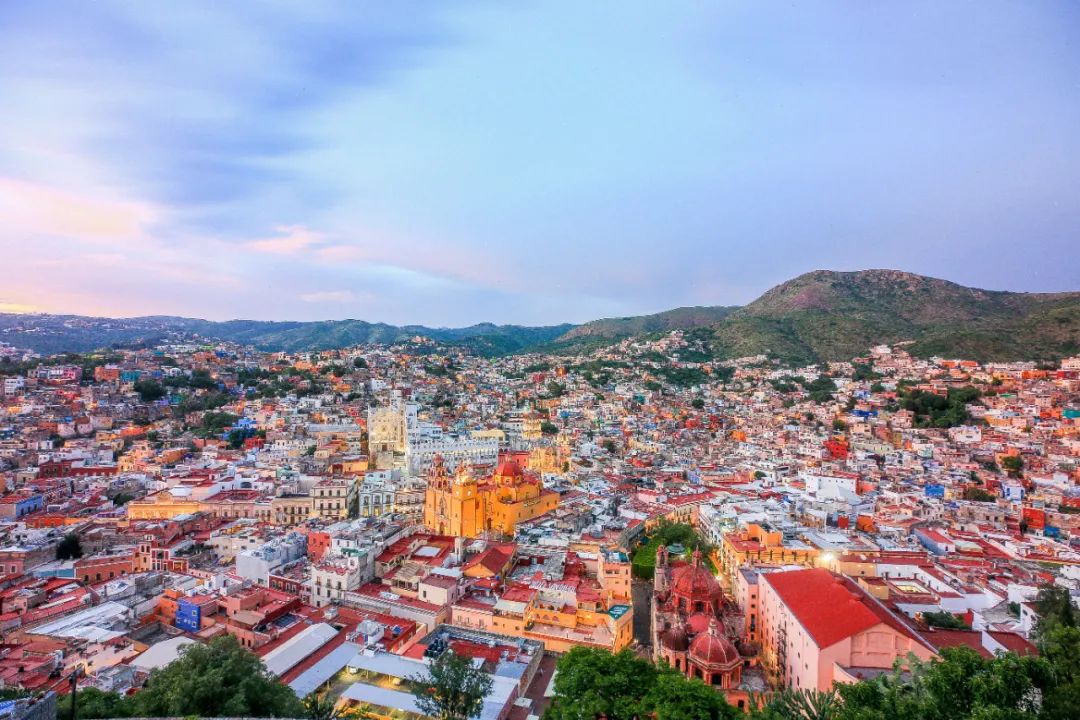
Day14. Guanajuato
The most popular cities in Mexico are Guanajuato. The Pixar animated film "Coco" was set against the backdrop of the traditional Mexican festival "Day of the Dead" and told a story about dreams and family love, which made many viewers shed tears in the theater. The protagonist MiG brings a guitar and travels to the world of the dead by chance and begins a dream-seeking journey. The majestic Land of the Dead in the film is based on Guanajuato. It seems that no city is as exaggerated in color and three-dimensionality as Guanajuato; Guanajuato rose because of its silver mines. In the colonial era, the output of silver mines exceeded two-thirds of the world's total output, and silver brought here With the arrival of great wealth, this miracle city was created. The small town is located in a narrow valley. The unique topography makes it have intricate streets and alleys. Not only that, there is a more complex tunnel system under Guanajuato. The three-dimensional city completely loses the function of Google Maps. Of course, walking is the only way to visit The best approach to the city.
Take the Funicular up the mountain from the city to reach the highest point of Guanajuato : Pipila Peak, standing on the top of the mountain overlooking the valley The small town is like a grand theater. The last golden light of the setting sun shines in the center of the city. The colors and music from the distance hit us like a roaring mountain and a tsunami. When the lanterns first come on, there is an indescribable feeling.


Mexico Self-Driving Guide
(Updated to 2018/5, hope it will also apply after the epidemic)
car rental
Well-known car rental companies in Europe and the United States have outlets in transportation hubs/city centers of major cities in Mexico. You can normally book online or through third-party platforms such as Kayak, Expedia, etc. Ctrip and Car Rental in China also provide car rental services in Mexico. More importantly, the prices on domestic websites are more reasonable! The cost of returning a car to other places in Mexico is extremely high, which also led to the fact that this trip was rented in Mexico City and returned in Mexico City. The choice of car rental company is not too important, just choose whichever one is cheaper. Insurance is very important when renting a car in Mexico. Although I didn’t encounter anything like car damage during the 15 days, the road conditions in the mountainous areas of central Mexico are very poor. Fortunately, I bought full insurance, and the rescue costs for a tire puncture midway were also covered by this part of the premium.
road conditions
The road conditions in Mexico are generally pretty good; the highway conditions around Mexico City, Campeche, and the Yucatan Peninsula are very good and are very suitable for self-driving.
Although the road conditions in Chiapas and the mountainous areas of central Mexico (Oaxaca, Oaxaca) are poor, due to inconvenient transportation, the links between various cities can only be connected by plane and long-distance bus (10-12 hours), so it is also Self-driving is highly recommended.
There are a lot of Topes on ordinary roads in the three provinces of Yucatan, Campeche and Chiapas. The so-called Topes are actually speed bumps on the road. There are very few Topes in the mountainous areas of central Mexico. You must drive carefully. It is quite dangerous to bump into them at high speed at night.
Guanajuato and San Miguel are also suitable for self-driving if you have a strong sense of direction. The whole journey from Mexico City to the above two cities is high-speed. However, due to the mountain towns, many 2-minute walks after entering the city are difficult to drive. It requires a large circle. Most of the roads in the city are one-way and have steep slopes. After driving around for a few times to get your bearings, you can drive smoothly.
Safety
In addition to driving faster, Mexican drivers are also very friendly; when encountering a speed bump or an emergency ahead, they will actively flash their double flashes to signal the cars behind them; slow-moving cars on the highway will actively pull to the right and then flash left The turn signal reminds the car behind that it is safe to overtake. Even when there is a police car ahead to check for speeding, the oncoming vehicle will turn on its high beam and flash wildly to signal the following vehicle to slow down.
Mexicans drive extremely fast. Just like the United States, on roads with a speed limit of 100 kilometers, there are many people driving 160 kilometers around. There are very few police cars patrolling the road. If you drive a little slower on a two-way two-lane road, you will be flashed by the following vehicles, which makes driving very stressful.
In the mountainous areas of central Mexico (Chiapas and Oaxaca), you will encounter many people who block the road and ask for tolls; they are children who "block" the road with a piece of wire or a branch, and then ask you for tolls. money. Just ignore them at this time. Try not to put obvious belongings (cash, banknotes, computers, cameras, mobile phones) in the car, otherwise the children will hold the car window and keep staring. When they see that you do not respond or there is a backlog of vehicles, they will take the initiative to "let it go." . Many travelogues in Mexico mentioned that they would be "bribed" or "extorted" by the police, but I never encountered them. The locals were warm and friendly.
language
Language seems to be the biggest barrier for most people traveling to Mexico. There is no need to worry. Even though the English penetration rate among Mexican locals is very low, in major tourist attractions, especially the Yucatan Peninsula, Mexico City and other places, tourism practitioners will use some English to a greater or lesser extent, and the local people are warm and hospitable. , if you see an Asian face in trouble, you will definitely come forward to help. Of course, although there is no need to learn Spanish for daily conversation, it is definitely not a bad thing if you can say a few simple words and always say thank you (Gracias).

Discover More
Comments
No comments yet